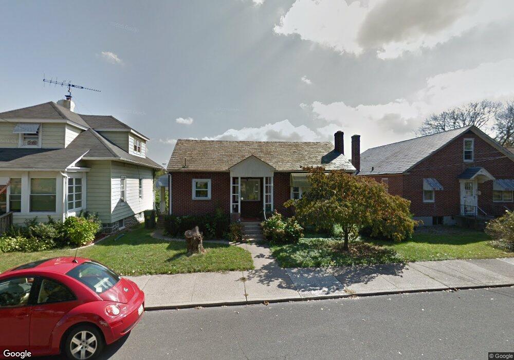
203 S 10th St Quakertown, PA 18951
Estimated Value: $276,000 - $297,523
2
Beds
1
Bath
852
Sq Ft
$331/Sq Ft
Est. Value
About This Home
This home is located at 203 S 10th St, Quakertown, PA 18951 and is currently estimated at $282,131, approximately $331 per square foot. 203 S 10th St is a home located in Bucks County with nearby schools including Quakertown Elementary School, Strayer Middle School, and Quakertown Community Senior High School.
Ownership History
Date
Name
Owned For
Owner Type
Purchase Details
Closed on
Dec 6, 2019
Sold by
Crossan Charles M
Bought by
Crossan Charles M and Crossan Anna
Current Estimated Value
Home Financials for this Owner
Home Financials are based on the most recent Mortgage that was taken out on this home.
Original Mortgage
$134,000
Outstanding Balance
$118,371
Interest Rate
3.7%
Mortgage Type
New Conventional
Estimated Equity
$163,760
Purchase Details
Closed on
May 13, 2011
Sold by
Kalnins Anna
Bought by
Crossan Charles M
Home Financials for this Owner
Home Financials are based on the most recent Mortgage that was taken out on this home.
Original Mortgage
$148,186
Interest Rate
4.88%
Mortgage Type
New Conventional
Purchase Details
Closed on
Sep 9, 1968
Bought by
Kalnins Karlis and Kalnins Anna
Create a Home Valuation Report for This Property
The Home Valuation Report is an in-depth analysis detailing your home's value as well as a comparison with similar homes in the area
Home Values in the Area
Average Home Value in this Area
Purchase History
| Date | Buyer | Sale Price | Title Company |
|---|---|---|---|
| Crossan Charles M | -- | None Available | |
| Crossan Charles M | $143,000 | None Available | |
| Kalnins Karlis | -- | -- |
Source: Public Records
Mortgage History
| Date | Status | Borrower | Loan Amount |
|---|---|---|---|
| Open | Crossan Charles M | $134,000 | |
| Closed | Crossan Charles M | $148,186 |
Source: Public Records
Tax History Compared to Growth
Tax History
| Year | Tax Paid | Tax Assessment Tax Assessment Total Assessment is a certain percentage of the fair market value that is determined by local assessors to be the total taxable value of land and additions on the property. | Land | Improvement |
|---|---|---|---|---|
| 2025 | $3,382 | $16,800 | $3,160 | $13,640 |
| 2024 | $3,382 | $16,800 | $3,160 | $13,640 |
| 2023 | $455 | $16,800 | $3,160 | $13,640 |
| 2022 | $3,291 | $16,800 | $3,160 | $13,640 |
| 2021 | $3,291 | $16,800 | $3,160 | $13,640 |
| 2020 | $3,291 | $16,800 | $3,160 | $13,640 |
| 2019 | $3,200 | $16,800 | $3,160 | $13,640 |
| 2018 | $3,089 | $16,800 | $3,160 | $13,640 |
| 2017 | $2,993 | $16,800 | $3,160 | $13,640 |
| 2016 | $2,993 | $16,800 | $3,160 | $13,640 |
| 2015 | -- | $16,800 | $3,160 | $13,640 |
| 2014 | -- | $16,800 | $3,160 | $13,640 |
Source: Public Records
Map
Nearby Homes
- 232 S 10th St
- 908 Juniper St
- 27 S 7th St
- 36 S Main St
- 803 W Broad St
- 811 W Mill St
- 306 Juniper St
- 112 Jefferson Ct
- 89 Braithwaite Ln
- 94 Braithwaite Ln
- 141 S 2nd St
- 56 Dewsbury Ln
- 21 Beaver Run Dr
- 1068 Freedom Ct
- 34 N Ambler St
- 1206 Arbor Ct
- 92 Laurel Ct
- 8 Fonthill Ct
- 262 Fairview Ave
- 12 Wagon Wheel Rd Unit 12