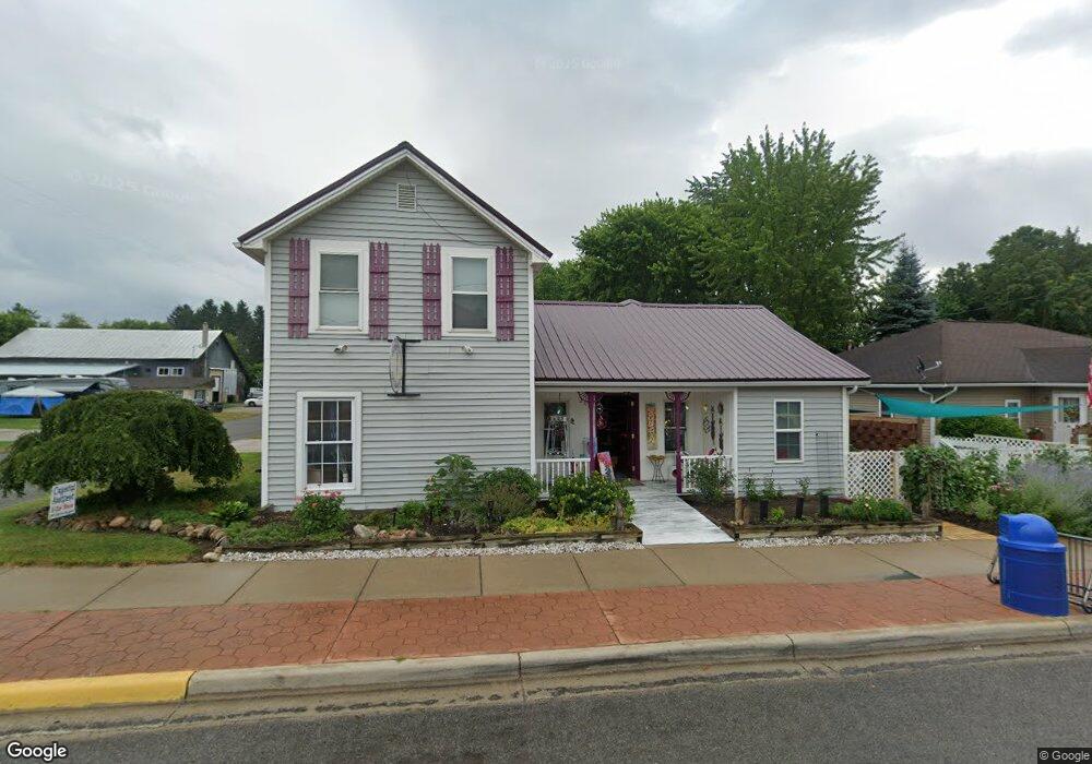
203 S Main St Crystal, MI 48818
1
Bed
2
Baths
1,700
Sq Ft
13,068
Sq Ft Lot
About This Home
This home is located at 203 S Main St, Crystal, MI 48818. 203 S Main St is a home located in Montcalm County with nearby schools including Carson City Elementary School, Carson City-Crystal Upper Elementary/Middle School, and Carson City-Crystal High School.
Ownership History
Date
Name
Owned For
Owner Type
Purchase Details
Closed on
Nov 21, 2023
Sold by
Huberty Pamela J
Bought by
Holbein Jodi Lynn
Purchase Details
Closed on
May 21, 2015
Sold by
Greenhoe James M
Bought by
Greenhoe Pamela J
Purchase Details
Closed on
May 31, 2007
Sold by
Reo Properties Corp
Bought by
Greenhoe Pamela
Purchase Details
Closed on
May 29, 2007
Sold by
Reo Properties Corp
Bought by
Greenhoe Pamela
Purchase Details
Closed on
Aug 10, 2006
Sold by
Western Carol Ann and Western Roy Rogers
Bought by
Reo Properties Corp
Purchase Details
Closed on
Mar 1, 2001
Sold by
Western Roy R & Carol A
Bought by
Co Treas 1999 Tax
Purchase Details
Closed on
Nov 11, 1994
Sold by
Fox Clarence H
Bought by
Western Roy & Carol
Purchase Details
Closed on
Nov 1, 1994
Create a Home Valuation Report for This Property
The Home Valuation Report is an in-depth analysis detailing your home's value as well as a comparison with similar homes in the area
Purchase History
| Date | Buyer | Sale Price | Title Company |
|---|---|---|---|
| Holbein Jodi Lynn | -- | Land Title | |
| Greenhoe Pamela J | -- | None Available | |
| Greenhoe Pamela | $25,500 | -- | |
| Greenhoe Pamela | $25,500 | -- | |
| Reo Properties Corp | $105,198 | None Available | |
| Reo Properties Corp | -- | -- | |
| Co Treas 1999 Tax | -- | -- | |
| Western Roy & Carol | -- | -- | |
| -- | -- | -- |
Source: Public Records
Tax History
| Year | Tax Paid | Tax Assessment Tax Assessment Total Assessment is a certain percentage of the fair market value that is determined by local assessors to be the total taxable value of land and additions on the property. | Land | Improvement |
|---|---|---|---|---|
| 2025 | $1,091 | $30,800 | $0 | $0 |
| 2024 | $1,003 | $25,900 | $0 | $0 |
| 2023 | -- | $23,500 | $0 | $0 |
Source: Public Records
Map
Nearby Homes
- 305 E Lasalle St
- 802 Parker St
- 8652 E Colby Rd
- 8386 E Sidney Rd
- 2695 Ovid St
- 1283 S Waldron Rd
- 2100 Strait Tow Blvd
- 890 S Senator Rd
- 4337 Holland Lake Rd
- 1050 Wicker Rd SE
- 3545 S Roy Dr
- 4218 E Klees Rd
- Lot A Blackmer Rd
- 7518 S Crystal Rd
- 6758 S Mount Hope Rd
- 5019 S Townhall Rd
- 8093 S Bloomer St
- 4685 Meadow View Dr
- 4668 Meadow View Dr
- 115 N 2nd St
- 209 S Main St Unit 207
- 210 S Main St
- 118 Park St
- 215 S Main St
- 121 S Main St
- 114 W Park St
- 223 S Main St
- 204 Lincoln St
- 214 Lincoln St
- 233 S Main St
- 117 E Lasalle St
- 114 S Main St
- 123 E Lasalle St
- 114 Park St
- 101&103 S Main St
- 205 Lincoln St
- 209 Lincoln St
- 101 S Main St
- 106 E Lasalle St
- 102 S Main St
Your Personal Tour Guide
Ask me questions while you tour the home.