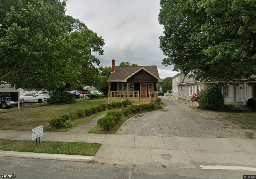
203 S Main St Middle Township, NJ 08210
Estimated Value: $514,603
4
Beds
1
Bath
1,038
Sq Ft
$496/Sq Ft
Est. Value
About This Home
This home is located at 203 S Main St, Middle Township, NJ 08210 and is currently estimated at $514,603, approximately $495 per square foot. 203 S Main St is a home located in Cape May County with nearby schools including Middle Township Elementary No. 1, Middle Township Elementary No. 2, and Middle Township Middle School.
Ownership History
Date
Name
Owned For
Owner Type
Purchase Details
Closed on
Aug 15, 2024
Sold by
203 South Main Street Llc
Bought by
Ward Palmer and Borucki Elizabeth
Current Estimated Value
Purchase Details
Closed on
May 14, 2004
Sold by
Desantis Mario and Desantis Serafine Jeanmarie
Bought by
203 South Main Street Llc
Home Financials for this Owner
Home Financials are based on the most recent Mortgage that was taken out on this home.
Original Mortgage
$184,000
Interest Rate
3.95%
Mortgage Type
Commercial
Create a Home Valuation Report for This Property
The Home Valuation Report is an in-depth analysis detailing your home's value as well as a comparison with similar homes in the area
Home Values in the Area
Average Home Value in this Area
Purchase History
| Date | Buyer | Sale Price | Title Company |
|---|---|---|---|
| Ward Palmer | $412,000 | Shore Title | |
| Ward Palmer | $412,000 | Shore Title | |
| 203 South Main Street Llc | $230,000 | -- |
Source: Public Records
Mortgage History
| Date | Status | Borrower | Loan Amount |
|---|---|---|---|
| Previous Owner | 203 South Main Street Llc | $184,000 |
Source: Public Records
Tax History Compared to Growth
Tax History
| Year | Tax Paid | Tax Assessment Tax Assessment Total Assessment is a certain percentage of the fair market value that is determined by local assessors to be the total taxable value of land and additions on the property. | Land | Improvement |
|---|---|---|---|---|
| 2025 | $6,660 | $315,800 | $174,000 | $141,800 |
| 2024 | $6,660 | $315,800 | $174,000 | $141,800 |
| 2023 | $6,493 | $315,800 | $174,000 | $141,800 |
| 2022 | $6,307 | $315,800 | $174,000 | $141,800 |
| 2021 | $6,155 | $315,800 | $174,000 | $141,800 |
| 2020 | $6,029 | $315,800 | $174,000 | $141,800 |
| 2019 | $5,874 | $315,800 | $174,000 | $141,800 |
| 2018 | $5,782 | $315,800 | $174,000 | $141,800 |
| 2017 | $5,665 | $315,800 | $174,000 | $141,800 |
| 2016 | $5,523 | $315,800 | $174,000 | $141,800 |
| 2015 | $5,482 | $315,800 | $174,000 | $141,800 |
| 2014 | $5,448 | $315,800 | $174,000 | $141,800 |
Source: Public Records
Map
Nearby Homes
- 215 S Boyd St
- 33 E Mechanic St
- 105 E Atlantic Ave
- 310 Front St
- 306 3rd St
- 212 Shunpike Rd
- 220 Hand Ave
- 24 Church St
- 26 Crest Rd
- 211 Colonial Ave
- 13 Poplar St
- 706 Bennett Rd
- 100 Osprey Dr Unit 100
- 5 Locust Ln
- 144 Lee Ln Unit Front
- 104 Bay Breeze Blvd Unit 104
- 3 Whimbrel Way Unit B1
- 3 Whimbrel Way Unit 3 Whimbrel
- 106 Bay Breeze Blvd Unit 106
- 308 Osprey Dr Unit 1003E1
- 207 S Main St
- 106 S Main St
- 202 S Main St
- 104 S Main St
- 11 Bennett Rd
- 102 N Main St Unit B
- 206 S Main St
- 107 Douglass Rd
- 105 Douglass Rd
- 102 Bennett Rd
- 204 Douglass Rd
- 106 Douglass Rd
- 104 Bennett Rd Unit 105B
- 101 Steel Rd
- 103 Bennett Rd
- 2 Steel Rd
- 206 Douglass Rd
- 21 Hand Ave
- 14 S Main St
- 208 S Boyd St