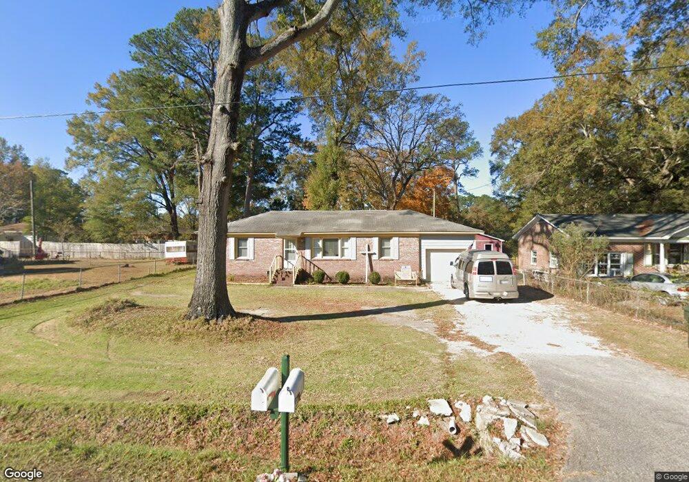
203 Vine St Goose Creek, SC 29445
Estimated Value: $276,532 - $316,000
3
Beds
3
Baths
1,490
Sq Ft
$195/Sq Ft
Est. Value
About This Home
This home is located at 203 Vine St, Goose Creek, SC 29445 and is currently estimated at $289,883, approximately $194 per square foot. 203 Vine St is a home located in Berkeley County with nearby schools including Boulder Bluff Elementary School, Sedgefield Middle School, and Goose Creek High School.
Ownership History
Date
Name
Owned For
Owner Type
Purchase Details
Closed on
Mar 1, 2011
Sold by
First Federal Savings & Loan Association
Bought by
Ardito Salvatore
Current Estimated Value
Purchase Details
Closed on
Nov 23, 2010
Sold by
Gilstrap Glenn W and Gilstrap Ray M
Bought by
First Federal Savings & Loan Association
Purchase Details
Closed on
Feb 1, 2007
Sold by
Tudor Bennie E and Tudor Bennie E
Bought by
Gilstrap Glenn W and Gilstrap Ray M
Home Financials for this Owner
Home Financials are based on the most recent Mortgage that was taken out on this home.
Original Mortgage
$102,400
Interest Rate
6.12%
Mortgage Type
Purchase Money Mortgage
Purchase Details
Closed on
May 5, 2006
Sold by
Clubb James E and Clubb Topzi J
Bought by
Tudor Bennie E and Tudor Bennie E
Create a Home Valuation Report for This Property
The Home Valuation Report is an in-depth analysis detailing your home's value as well as a comparison with similar homes in the area
Home Values in the Area
Average Home Value in this Area
Purchase History
| Date | Buyer | Sale Price | Title Company |
|---|---|---|---|
| Ardito Salvatore | $55,500 | -- | |
| First Federal Savings & Loan Association | $98,500 | -- | |
| Gilstrap Glenn W | $128,000 | None Available | |
| Tudor Bennie E | $39,000 | None Available |
Source: Public Records
Mortgage History
| Date | Status | Borrower | Loan Amount |
|---|---|---|---|
| Previous Owner | Gilstrap Glenn W | $102,400 |
Source: Public Records
Tax History Compared to Growth
Tax History
| Year | Tax Paid | Tax Assessment Tax Assessment Total Assessment is a certain percentage of the fair market value that is determined by local assessors to be the total taxable value of land and additions on the property. | Land | Improvement |
|---|---|---|---|---|
| 2025 | $395 | $95,511 | $15,341 | $80,170 |
| 2024 | $395 | $3,821 | $614 | $3,207 |
| 2023 | $395 | $3,821 | $614 | $3,207 |
| 2022 | $359 | $3,322 | $553 | $2,769 |
| 2021 | $363 | $3,320 | $553 | $2,769 |
| 2020 | $365 | $3,322 | $553 | $2,769 |
| 2019 | $364 | $3,322 | $553 | $2,769 |
| 2018 | $329 | $2,889 | $567 | $2,322 |
| 2017 | $289 | $2,889 | $567 | $2,322 |
| 2016 | $291 | $2,890 | $570 | $2,320 |
| 2015 | $282 | $2,890 | $570 | $2,320 |
| 2014 | $276 | $2,890 | $570 | $2,320 |
| 2013 | -- | $2,890 | $570 | $2,320 |
Source: Public Records
Map
Nearby Homes
- 229 Lindy Creek Rd
- 116 Blossom St
- 3 Tommy Cir
- 208 Mary Scott Dr
- 216 Lindy Creek Rd
- 235 Mary Scott Dr
- 103 Kathryn Dr
- 102 Amberside Dr
- 318 Jean Wells Dr
- 334 Water Oak Dr
- 0 Liberty Hall Rd Unit 25007657
- 429 Stephanie Dr
- 110 Red Cypress Dr
- Lot 3 Thurgood Dr
- 215 Woodland Lakes Rd
- 159 Nello Dr
- 128 Foxborough Rd
- 401 Amy Dr
- 204 Cane Break Ln
- 102 Brush Blvd