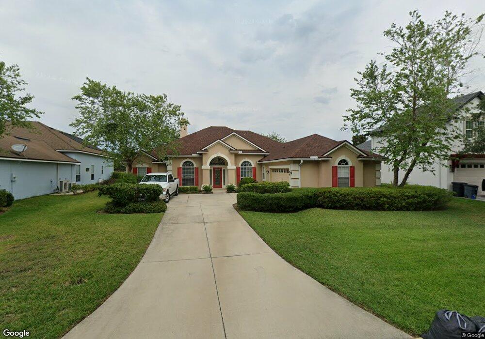
2030 Rivers Own Rd Saint Augustine, FL 32092
Estimated Value: $523,000 - $561,000
4
Beds
4
Baths
2,970
Sq Ft
$183/Sq Ft
Est. Value
About This Home
This home is located at 2030 Rivers Own Rd, Saint Augustine, FL 32092 and is currently estimated at $543,274, approximately $182 per square foot. 2030 Rivers Own Rd is a home located in St. Johns County with nearby schools including Wards Creek Elementary School, Pacetti Bay Middle School, and Mill Creek Baptist Christian Academy.
Ownership History
Date
Name
Owned For
Owner Type
Purchase Details
Closed on
Aug 24, 2006
Sold by
White Mimi
Bought by
White Mimi M and Mimi M White Living Trust
Current Estimated Value
Purchase Details
Closed on
Jun 10, 2005
Sold by
Providence Construction Co
Bought by
White Mimi
Home Financials for this Owner
Home Financials are based on the most recent Mortgage that was taken out on this home.
Original Mortgage
$267,239
Outstanding Balance
$137,173
Interest Rate
5.5%
Mortgage Type
Fannie Mae Freddie Mac
Estimated Equity
$406,101
Create a Home Valuation Report for This Property
The Home Valuation Report is an in-depth analysis detailing your home's value as well as a comparison with similar homes in the area
Purchase History
| Date | Buyer | Sale Price | Title Company |
|---|---|---|---|
| White Mimi M | -- | Attorney | |
| White Mimi | $334,100 | Southern Title Holding Compa |
Source: Public Records
Mortgage History
| Date | Status | Borrower | Loan Amount |
|---|---|---|---|
| Open | White Mimi | $267,239 |
Source: Public Records
Tax History Compared to Growth
Tax History
| Year | Tax Paid | Tax Assessment Tax Assessment Total Assessment is a certain percentage of the fair market value that is determined by local assessors to be the total taxable value of land and additions on the property. | Land | Improvement |
|---|---|---|---|---|
| 2025 | $4,667 | $223,168 | -- | -- |
| 2024 | $4,667 | $216,879 | -- | -- |
| 2023 | $4,667 | $210,562 | $0 | $0 |
| 2022 | $4,188 | $204,429 | $0 | $0 |
| 2021 | $4,067 | $198,475 | $0 | $0 |
| 2020 | $4,006 | $195,735 | $0 | $0 |
| 2019 | $4,021 | $191,334 | $0 | $0 |
| 2018 | $3,990 | $187,766 | $0 | $0 |
| 2017 | $3,964 | $183,904 | $0 | $0 |
| 2016 | $4,329 | $185,525 | $0 | $0 |
| 2015 | $4,363 | $184,235 | $0 | $0 |
| 2014 | $4,490 | $175,906 | $0 | $0 |
Source: Public Records
Map
Nearby Homes
- 1225 Splendid Ravine St Unit 1
- 1233 Splendid Ravine St
- 2454 Woodstork Ct
- 1236 Splendid Ravine St
- 1700 Windover Place
- 1336 River City St
- 626 Sweet Orange Terrace
- 812 Wards Creek Ln
- 1147 Hyacinth St
- 3164 Trout Creek Ct
- 760 Flowers St
- 7070 State Road 16
- 4640 Tuscan Wood Ct
- 4448 N Alatamaha St
- 3533 Crest St
- 5012 Clayton Ct
- 2844 Oakgrove Ave
- 8521 County Road 13 N
- 3570 Joe Ashton Rd
- 5133 Foliage Way
- 2034 Rivers Own Rd
- 2024 Rivers Own Rd
- 322 River's Own Rd
- Lot 319 River's Own Rd
- 2038 River's Own Rd
- 2038 Rivers Own Rd
- 2018 Rivers Own Rd
- 2029 River's Own Rd
- 2029 Rivers Own Rd
- 2025 Rivers Own Rd
- 2033 Rivers Own Rd
- 2044 Rivers Own Rd
- 2037 Rivers Own Rd
- 2021 Rivers Own Rd
- 2044 River's Own Rd
- 2012 Rivers Own Rd
- 2041 Rivers Own Rd
- 2041 River's Own Rd
- 2017 Rivers Own Rd
- 2017 River's Own Rd