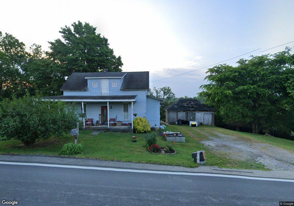
2030 State Route 41 Peebles, OH 45660
Estimated Value: $114,371 - $147,000
--
Bed
--
Bath
--
Sq Ft
17.25
Acres
About This Home
This home is located at 2030 State Route 41, Peebles, OH 45660 and is currently estimated at $130,686. 2030 State Route 41 is a home with nearby schools including Peebles Elementary School and Peebles High School.
Ownership History
Date
Name
Owned For
Owner Type
Purchase Details
Closed on
Apr 14, 2006
Sold by
Green Mildred
Bought by
Bishop Daniel T and Bishop Sharon K
Current Estimated Value
Purchase Details
Closed on
Mar 25, 1996
Sold by
Green Frank
Bought by
Bishop Daniel T and Bishop Sharon
Purchase Details
Closed on
Jan 1, 1990
Bought by
Green Frank and Green Mildred
Create a Home Valuation Report for This Property
The Home Valuation Report is an in-depth analysis detailing your home's value as well as a comparison with similar homes in the area
Home Values in the Area
Average Home Value in this Area
Purchase History
| Date | Buyer | Sale Price | Title Company |
|---|---|---|---|
| Bishop Daniel T | $32,500 | None Available | |
| Bishop Daniel T | $32,500 | -- | |
| Green Frank | -- | -- |
Source: Public Records
Mortgage History
| Date | Status | Borrower | Loan Amount |
|---|---|---|---|
| Closed | Bishop Daniel T | $0 |
Source: Public Records
Tax History Compared to Growth
Tax History
| Year | Tax Paid | Tax Assessment Tax Assessment Total Assessment is a certain percentage of the fair market value that is determined by local assessors to be the total taxable value of land and additions on the property. | Land | Improvement |
|---|---|---|---|---|
| 2024 | $662 | $20,830 | $19,290 | $1,540 |
| 2023 | $662 | $17,650 | $16,770 | $880 |
| 2022 | $578 | $17,650 | $16,770 | $880 |
| 2021 | $625 | $17,650 | $16,770 | $880 |
| 2020 | $605 | $16,040 | $15,230 | $810 |
| 2019 | $597 | $16,040 | $15,230 | $810 |
| 2018 | $713 | $16,180 | $15,230 | $950 |
| 2017 | $613 | $16,250 | $15,230 | $1,020 |
| 2016 | $612 | $16,250 | $15,230 | $1,020 |
| 2015 | $611 | $16,250 | $15,230 | $1,020 |
| 2014 | $600 | $15,470 | $14,490 | $980 |
| 2013 | $607 | $15,470 | $14,490 | $980 |
Source: Public Records
Map
Nearby Homes
- 9 Sugar St
- 13970 Sinking Spring Rd
- 34292 State Route 41
- 0 Nace Corner Rd
- 2090 Dutch Thomas Rd
- 12466 Sinking Spring Rd
- 664 Strait Creek Rd
- 3750 Ohio 124
- 1445 S Elmville Rd
- 11883 Walnut Shade Rd
- 289 Elmville Rd
- 20231 State Route 41
- McCoy Rd Lot Unit Wp001
- 1646 Bell Hollow Rd
- A Seaman Rd
- 134 Seaman Rd
- 1225 Stoney Rd
- 5283 Drybone Rd
- 1721 May Hill Rd
- 331 Swayne Rd
- 1966 State Route 41
- 1996 State Route 41
- 2036 State Route 41
- 2673 State Route 41
- 1051 State Route 41
- 450 Main St S
- 430 Main St S
- 24 S Main St S
- 326 Main St
- 326 Main St S
- 16 Main St
- 24 W Water St
- 1 Old Smokey Corner Rd
- 23 S Main St S
- 4 Water St
- 101 S Main St
- 4-E Water St
- 14 W Water St W
- 0 St Rt 124
- 18 W Water St