Estimated Value: $495,000 - $713,000
4
Beds
2
Baths
1,576
Sq Ft
$359/Sq Ft
Est. Value
About This Home
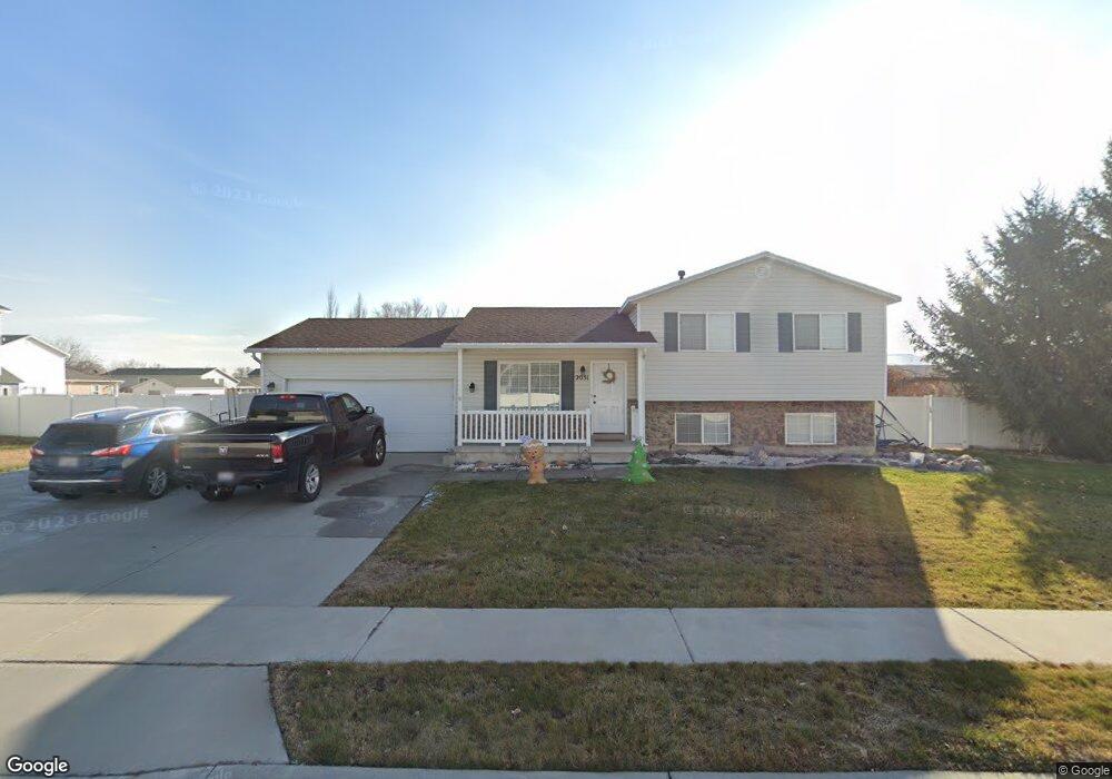
This home is located at 2031 W 1835 N, Lehi, UT 84043 and is currently estimated at $565,874, approximately $359 per square foot. 2031 W 1835 N is a home located in Utah County with nearby schools including North Point Elementary School, Willowcreek Middle School, and Lehi High School.
Ownership History
Date
Name
Owned For
Owner Type
Purchase Details
Closed on
Sep 12, 2024
Sold by
Barrantes Marcos Emilio and Barrantes Heather Wyora
Bought by
Eisenhour Weston K and Avis Makenzie
Current Estimated Value
Home Financials for this Owner
Home Financials are based on the most recent Mortgage that was taken out on this home.
Original Mortgage
$499,987
Outstanding Balance
$494,638
Interest Rate
6.73%
Mortgage Type
New Conventional
Estimated Equity
$71,236
Purchase Details
Closed on
Aug 26, 2016
Sold by
Schow Norman G and Schow Cindy B
Bought by
Barrantes Marcos Emilio and Barrantes Heather Wyora
Purchase Details
Closed on
Dec 29, 2014
Sold by
Pilling Nathan E and Pilling Deborah
Bought by
Barrantes Marcos Emilio and Barrantes Heather Wyora
Home Financials for this Owner
Home Financials are based on the most recent Mortgage that was taken out on this home.
Original Mortgage
$215,000
Interest Rate
3.96%
Mortgage Type
Purchase Money Mortgage
Purchase Details
Closed on
Jun 29, 2006
Sold by
Schow Christopher G and Schow Stephanie L
Bought by
Pilling Nathan E and Pilling Deborah
Home Financials for this Owner
Home Financials are based on the most recent Mortgage that was taken out on this home.
Original Mortgage
$25,000
Interest Rate
6.66%
Mortgage Type
Credit Line Revolving
Purchase Details
Closed on
Jan 2, 2002
Sold by
Schow Christopher G and Schow Stephanie L
Bought by
Schow Christopher and Schow Stephanie
Home Financials for this Owner
Home Financials are based on the most recent Mortgage that was taken out on this home.
Original Mortgage
$136,400
Interest Rate
8.99%
Purchase Details
Closed on
Jun 22, 1999
Sold by
Salisbury Development Llc
Bought by
Schow Christopher G and Schow Stephanie L
Home Financials for this Owner
Home Financials are based on the most recent Mortgage that was taken out on this home.
Original Mortgage
$14,750
Interest Rate
7.01%
Mortgage Type
Seller Take Back
Purchase Details
Closed on
Jun 17, 1999
Sold by
Salisbury Development Lc
Bought by
Schow Christopher G and Schow Stephanie L
Home Financials for this Owner
Home Financials are based on the most recent Mortgage that was taken out on this home.
Original Mortgage
$14,750
Interest Rate
7.01%
Mortgage Type
Seller Take Back
Create a Home Valuation Report for This Property
The Home Valuation Report is an in-depth analysis detailing your home's value as well as a comparison with similar homes in the area
Home Values in the Area
Average Home Value in this Area
Purchase History
| Date | Buyer | Sale Price | Title Company |
|---|---|---|---|
| Eisenhour Weston K | -- | Capstone Title | |
| Barrantes Marcos Emilio | -- | First American | |
| Barrantes Marcos Emilio | -- | None Available | |
| Pilling Nathan E | -- | Equity Title Orem Blvd | |
| Schow Christopher | -- | -- | |
| Schow Christopher G | -- | Provo Land Title Company | |
| Schow Christopher G | -- | Provo Land Title Company |
Source: Public Records
Mortgage History
| Date | Status | Borrower | Loan Amount |
|---|---|---|---|
| Open | Eisenhour Weston K | $499,987 | |
| Previous Owner | Barrantes Marcos Emilio | $215,000 | |
| Previous Owner | Pilling Nathan E | $25,000 | |
| Previous Owner | Pilling Nathan E | $151,760 | |
| Previous Owner | Schow Christopher | $136,400 | |
| Previous Owner | Schow Christopher G | $14,750 |
Source: Public Records
Tax History Compared to Growth
Tax History
| Year | Tax Paid | Tax Assessment Tax Assessment Total Assessment is a certain percentage of the fair market value that is determined by local assessors to be the total taxable value of land and additions on the property. | Land | Improvement |
|---|---|---|---|---|
| 2025 | $1,971 | $470,700 | $208,000 | $262,700 |
| 2024 | $1,971 | $230,670 | $0 | $0 |
| 2023 | $1,806 | $229,515 | $0 | $0 |
| 2022 | $2,004 | $246,895 | $0 | $0 |
| 2021 | $1,768 | $329,300 | $120,400 | $208,900 |
| 2020 | $1,666 | $306,700 | $111,500 | $195,200 |
| 2019 | $1,489 | $284,900 | $111,500 | $173,400 |
| 2018 | $1,405 | $254,100 | $99,400 | $154,700 |
| 2017 | $1,359 | $130,680 | $0 | $0 |
| 2016 | $1,339 | $119,515 | $0 | $0 |
| 2015 | $1,310 | $110,935 | $0 | $0 |
| 2014 | $1,223 | $103,015 | $0 | $0 |
Source: Public Records
Map
Nearby Homes
- 1896 N 2230 W
- 1970 N 2090 St W
- Palisade Plan at Pioneer Meadows
- Silver Lake Plan at Pioneer Meadows
- Summit Plan at Pioneer Meadows
- Huntington Plan at Pioneer Meadows
- 1542 N 1900 W
- 2012 N 2040 W
- 1990 N 2040 W
- 2013 N 2040 W
- 1968 N 2040 W
- 1991 N 2040 St W
- 1969 N 2040 St W
- 1898 W Pointe Meadow Loop
- 4380 W Bergen Ln
- 2209 W Swift Fox Way Unit 271
- 2184 W Cape Fox Way N Unit 220
- 1060 N Canvasback Dr Unit 405
- 1488 N 1700 W
- 1820 N 3560 W