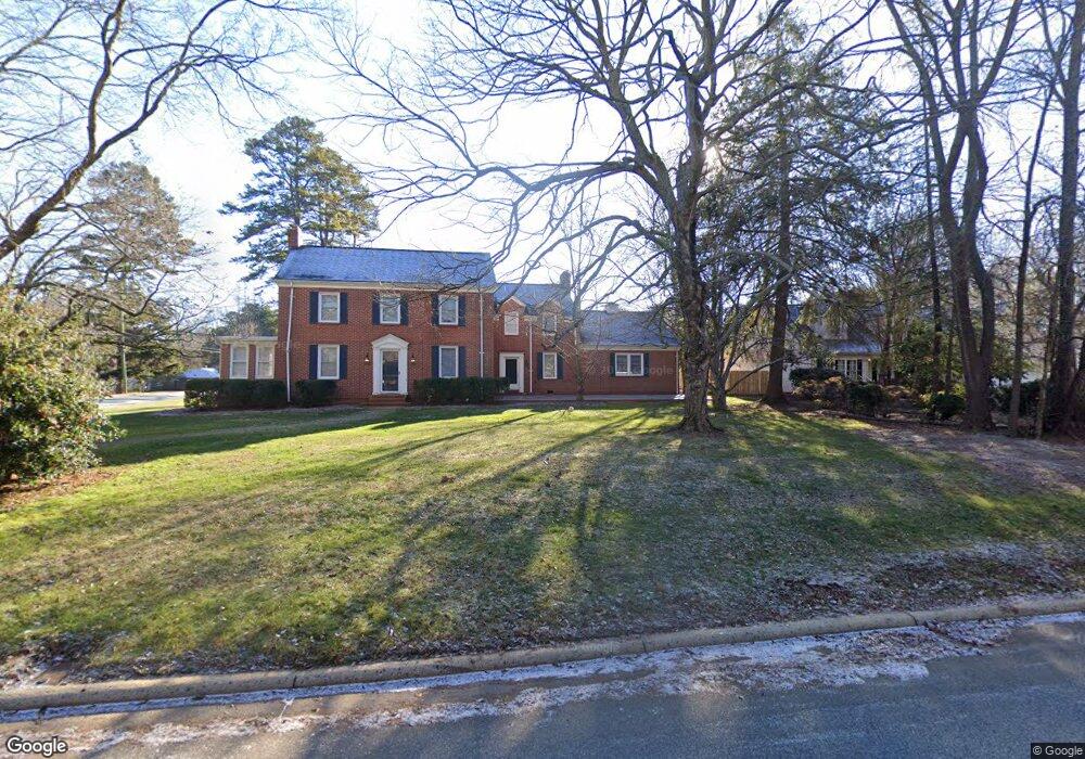
2032 Robin Rd Salisbury, NC 28144
Estimated Value: $336,000 - $448,614
4
Beds
3
Baths
3,395
Sq Ft
$112/Sq Ft
Est. Value
About This Home
This home is located at 2032 Robin Rd, Salisbury, NC 28144 and is currently estimated at $381,154, approximately $112 per square foot. 2032 Robin Rd is a home located in Rowan County with nearby schools including Carroll T Overton Elementary School, North Rowan Middle School, and Salisbury High School.
Ownership History
Date
Name
Owned For
Owner Type
Purchase Details
Closed on
Dec 23, 2014
Sold by
Citimortgage Inc
Bought by
Graham William M
Current Estimated Value
Home Financials for this Owner
Home Financials are based on the most recent Mortgage that was taken out on this home.
Original Mortgage
$96,000
Outstanding Balance
$73,304
Interest Rate
4.07%
Mortgage Type
Unknown
Estimated Equity
$307,850
Purchase Details
Closed on
May 15, 2014
Sold by
Butler Dennis D and Butler Sarah R
Bought by
Citimortgage Inc
Create a Home Valuation Report for This Property
The Home Valuation Report is an in-depth analysis detailing your home's value as well as a comparison with similar homes in the area
Home Values in the Area
Average Home Value in this Area
Purchase History
| Date | Buyer | Sale Price | Title Company |
|---|---|---|---|
| Graham William M | $120,000 | None Available | |
| Citimortgage Inc | $162,941 | None Available |
Source: Public Records
Mortgage History
| Date | Status | Borrower | Loan Amount |
|---|---|---|---|
| Open | Graham William M | $96,000 |
Source: Public Records
Tax History
| Year | Tax Paid | Tax Assessment Tax Assessment Total Assessment is a certain percentage of the fair market value that is determined by local assessors to be the total taxable value of land and additions on the property. | Land | Improvement |
|---|---|---|---|---|
| 2025 | $4,536 | $379,268 | $38,250 | $341,018 |
| 2024 | $4,536 | $379,268 | $38,250 | $341,018 |
| 2023 | $4,536 | $379,268 | $38,250 | $341,018 |
| 2022 | $2,437 | $176,996 | $29,453 | $147,543 |
| 2021 | $2,437 | $176,996 | $29,453 | $147,543 |
| 2020 | $2,437 | $176,996 | $29,453 | $147,543 |
| 2019 | $2,437 | $176,996 | $29,453 | $147,543 |
| 2018 | $2,349 | $172,854 | $29,484 | $143,370 |
| 2017 | $2,336 | $172,854 | $29,484 | $143,370 |
| 2016 | $2,272 | $172,854 | $29,484 | $143,370 |
| 2015 | $2,286 | $172,854 | $29,484 | $143,370 |
| 2014 | $2,848 | $217,947 | $29,484 | $188,463 |
Source: Public Records
Map
Nearby Homes
- 400 Statesville Blvd
- 636 Statesville Blvd
- 151 E Corriher Ave
- 0000 Hogans Valley Way Unit 181
- 519 Riviera Dr
- 1300 Larchmont Place Unit 402
- 1300 Larchmont Place Unit 504
- 1300 Larchmont Place
- 301 S Merritt Ave
- 1304 Brenner Ave
- 0 Hogans Valley Way Unit CAR4284662
- 0 Hogans Valley Way Unit CAR4284649
- 1625 Emerald Ave
- 225 Valleyview Place
- 106 Gallarie Place
- 2920 W Innes St
- 205 Windsor Dr
- 104 Gallarie Place
- 1329 W Bank St
- 113 S Milford Dr
- 2024 Robin Rd
- 515 Lantz Ave
- 2020 Robin Rd
- 518 Lantz Ave
- 2029 Robin Rd
- 501 Lantz Ave
- 2013 Schofield Place
- 2025 Robin Rd
- 2006 Robin Rd
- 602 Lantz Ave
- 2009 Schofield Place
- 2023 Robin Rd
- 2106 Robin Rd
- 2109 Robin Rd
- 2021 Robin Rd
- 516 Lantz Ave
- 2000 Robin Rd
- 2023 N Park Dr
- 2001 Schofield Place
- 424 Lantz Ave
Your Personal Tour Guide
Ask me questions while you tour the home.