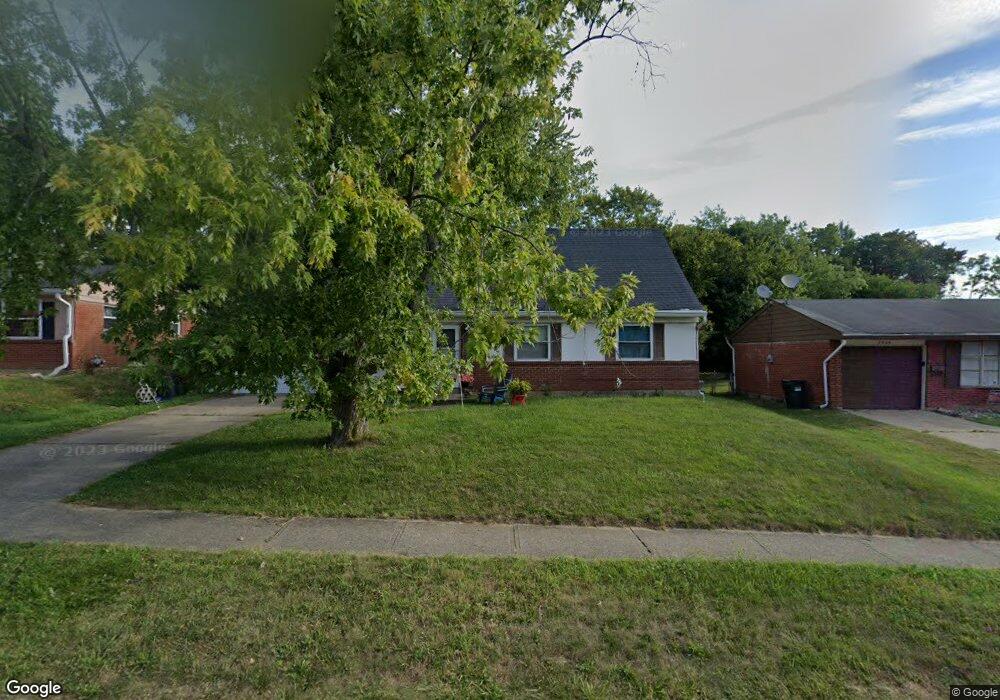
2032 Roosevelt Ave Cincinnati, OH 45240
New Burlington NeighborhoodEstimated Value: $177,000 - $219,000
5
Beds
2
Baths
1,480
Sq Ft
$133/Sq Ft
Est. Value
About This Home
This home is located at 2032 Roosevelt Ave, Cincinnati, OH 45240 and is currently estimated at $196,471, approximately $132 per square foot. 2032 Roosevelt Ave is a home located in Hamilton County with nearby schools including Mt Healthy High School, Hamilton County Mathematics and Science Academy, and Central Montessori Academy.
Ownership History
Date
Name
Owned For
Owner Type
Purchase Details
Closed on
Aug 30, 1995
Sold by
Long Michael
Bought by
Nichols Stella E
Current Estimated Value
Home Financials for this Owner
Home Financials are based on the most recent Mortgage that was taken out on this home.
Original Mortgage
$65,950
Interest Rate
7.55%
Create a Home Valuation Report for This Property
The Home Valuation Report is an in-depth analysis detailing your home's value as well as a comparison with similar homes in the area
Home Values in the Area
Average Home Value in this Area
Purchase History
We collect this data history from publicly available records. To have your information removed, we recommend requesting removal directly through your county’s website.
| Date | Buyer | Sale Price | Title Company |
|---|---|---|---|
| Nichols Stella E | -- | -- |
Source: Public Records
Mortgage History
We collect this data history from publicly available records. To have your information removed, we recommend requesting removal directly through your county’s website.
| Date | Status | Borrower | Loan Amount |
|---|---|---|---|
| Previous Owner | Nichols Stella E | $65,950 |
Source: Public Records
Tax History
| Year | Tax Paid | Tax Assessment Tax Assessment Total Assessment is a certain percentage of the fair market value that is determined by local assessors to be the total taxable value of land and additions on the property. | Land | Improvement |
|---|---|---|---|---|
| 2025 | $2,411 | $41,339 | $5,621 | $35,718 |
| 2024 | $2,389 | $41,339 | $5,621 | $35,718 |
| 2023 | $2,269 | $41,339 | $5,621 | $35,718 |
| 2022 | $1,534 | $20,062 | $4,949 | $15,113 |
| 2021 | $1,493 | $20,062 | $4,949 | $15,113 |
| 2020 | $1,516 | $20,062 | $4,949 | $15,113 |
| 2019 | $1,474 | $18,236 | $4,498 | $13,738 |
| 2018 | $1,482 | $18,236 | $4,498 | $13,738 |
| 2017 | $1,407 | $18,236 | $4,498 | $13,738 |
| 2016 | $1,681 | $21,515 | $5,226 | $16,289 |
| 2015 | $1,694 | $21,515 | $5,226 | $16,289 |
| 2014 | $1,686 | $21,515 | $5,226 | $16,289 |
| 2013 | $1,985 | $25,922 | $6,297 | $19,625 |
Source: Public Records
Map
Nearby Homes
- 2071 Roosevelt Ave
- 1990 Bluehill Dr
- 2097 Bluehill Dr
- 1931 Lotushill Dr
- 10897 Sprucehill Dr
- 1887 Lotushill Dr
- 10920 Crystalhill Ct
- 1854 Windmill Way
- 1855 Bluehill Dr
- 10945 Crystalhill Ct
- 1858 Aspenhill Dr
- 1884 Sevenhills Dr
- 2342 Washington Ave
- 2371 Wilson Ave
- 10731 Valiant Dr
- 1785 Acreview Dr
- 2192 Pinney Ln
- 10526 Breedshill Dr
- 1751 Mill Spring Ct
- 10380 Hawkhurst Dr
- 2040 Roosevelt Ave
- 2026 Roosevelt Ave
- 2046 Roosevelt Ave
- 2018 Roosevelt Ave
- 2033 Roosevelt Ave
- 2054 Roosevelt Ave
- 2012 Roosevelt Ave
- 2025 Roosevelt Ave
- 2041 Roosevelt Ave
- 2017 Roosevelt Ave
- 2049 Roosevelt Ave
- 2060 Roosevelt Ave
- 10813 Pleasanthill Dr
- 10803 Pleasanthill Dr
- 2011 Roosevelt Ave
- 2057 Roosevelt Ave
- 2042 Bluehill Dr
- 2032 Bluehill Dr
- 2068 Roosevelt Ave
- 2003 Roosevelt Ave
Your Personal Tour Guide
Ask me questions while you tour the home.