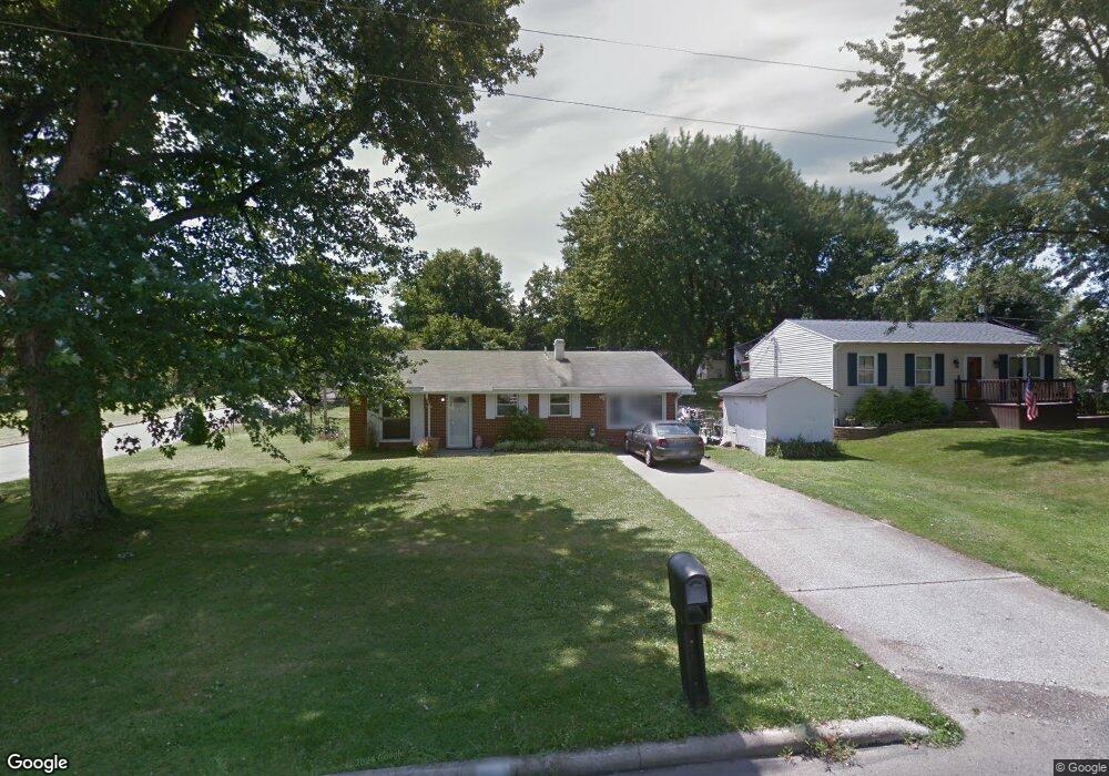
2032 Woodmont Rd Mansfield, OH 44905
Estimated Value: $140,000 - $170,000
3
Beds
1
Bath
1,232
Sq Ft
$128/Sq Ft
Est. Value
About This Home
This home is located at 2032 Woodmont Rd, Mansfield, OH 44905 and is currently estimated at $157,651, approximately $127 per square foot. 2032 Woodmont Rd is a home located in Richland County with nearby schools including Madison High School, St. Mary Catholic School, and Temple-Christian School.
Ownership History
Date
Name
Owned For
Owner Type
Purchase Details
Closed on
Nov 15, 2023
Sold by
Mathews Tyrone
Bought by
Ramirez Shatonga T and Ramirez Odilio B
Current Estimated Value
Home Financials for this Owner
Home Financials are based on the most recent Mortgage that was taken out on this home.
Original Mortgage
$147,283
Outstanding Balance
$144,709
Interest Rate
7.49%
Mortgage Type
FHA
Estimated Equity
$12,942
Purchase Details
Closed on
Dec 1, 1989
Purchase Details
Closed on
Jun 1, 1985
Create a Home Valuation Report for This Property
The Home Valuation Report is an in-depth analysis detailing your home's value as well as a comparison with similar homes in the area
Home Values in the Area
Average Home Value in this Area
Purchase History
| Date | Buyer | Sale Price | Title Company |
|---|---|---|---|
| Ramirez Shatonga T | $150,000 | Chicago Title | |
| -- | $35,900 | -- | |
| -- | $36,000 | -- |
Source: Public Records
Mortgage History
| Date | Status | Borrower | Loan Amount |
|---|---|---|---|
| Open | Ramirez Shatonga T | $147,283 |
Source: Public Records
Tax History Compared to Growth
Tax History
| Year | Tax Paid | Tax Assessment Tax Assessment Total Assessment is a certain percentage of the fair market value that is determined by local assessors to be the total taxable value of land and additions on the property. | Land | Improvement |
|---|---|---|---|---|
| 2024 | $1,942 | $37,820 | $4,140 | $33,680 |
| 2023 | $1,942 | $37,820 | $4,140 | $33,680 |
| 2022 | $1,662 | $29,740 | $3,730 | $26,010 |
| 2021 | $1,661 | $29,740 | $3,730 | $26,010 |
| 2020 | $1,674 | $29,740 | $3,730 | $26,010 |
| 2019 | $1,523 | $25,210 | $3,160 | $22,050 |
| 2018 | $1,510 | $25,210 | $3,160 | $22,050 |
| 2017 | $1,481 | $25,210 | $3,160 | $22,050 |
| 2016 | $1,480 | $24,570 | $3,000 | $21,570 |
| 2015 | $1,480 | $24,570 | $3,000 | $21,570 |
| 2014 | $1,451 | $24,570 | $3,000 | $21,570 |
| 2012 | $700 | $25,870 | $3,160 | $22,710 |
Source: Public Records
Map
Nearby Homes
- 1997 Hout Rd
- 1951 Woodmont Rd
- 1806 Richard Dr
- 1910 Crider Rd
- 2270 Lakecrest Dr Unit 2272
- 2202 Lakewood Dr
- 903 Mayflower Ave
- 1106 Keller Dr Unit 1108
- 640 Running Brook Way
- 1292 Wolford Rd
- 0 Satinwood Dr
- 630 Impala Dr
- 1151 Beal Rd
- 598 Impala Dr
- 1585 Beal Rd
- 1150 Delwood Dr
- 1158 Delwood Rd
- 683 Coachman Rd
- 671 Coachman Rd
- 1791 Beal Rd
- 2024 Woodmont Rd
- 2018 Woodmont Rd
- 2031 Farmdale Rd
- 2025 Farmdale Rd
- 2019 Farmdale Rd
- 2010 Woodmont Rd
- 2033 Woodmont Rd
- 2025 Woodmont Rd
- 2011 Farmdale Rd
- 2004 Woodmont Rd
- 2161 Woodmont Rd
- 2005 Farmdale Rd
- 1996 Woodmont Rd
- 2032 Farmdale Rd
- 2005 Woodmont Rd
- 2024 Farmdale Rd
- 12 Ledgewood Dr
- 1997 Farmdale Rd
- 28 Ledgewood Rd
- 2018 Farmdale Rd