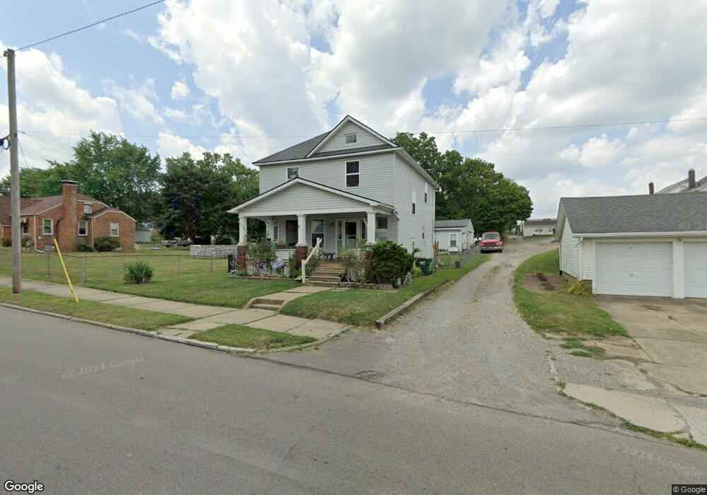
2033 S Seneca Ave Alliance, OH 44601
Estimated Value: $120,000 - $161,000
4
Beds
1
Bath
1,636
Sq Ft
$85/Sq Ft
Est. Value
About This Home
This home is located at 2033 S Seneca Ave, Alliance, OH 44601 and is currently estimated at $138,881, approximately $84 per square foot. 2033 S Seneca Ave is a home located in Stark County with nearby schools including Alliance Elementary School at Rockhill, Alliance Intermediate School at Northside, and Alliance Middle School.
Ownership History
Date
Name
Owned For
Owner Type
Purchase Details
Closed on
May 31, 2000
Sold by
Kimberly Woodard and Woodard Kimberly Woodard
Bought by
Salaski Darrell L and Salaski Tricia L
Current Estimated Value
Home Financials for this Owner
Home Financials are based on the most recent Mortgage that was taken out on this home.
Original Mortgage
$63,750
Outstanding Balance
$28,761
Interest Rate
12.25%
Mortgage Type
Purchase Money Mortgage
Estimated Equity
$110,120
Purchase Details
Closed on
May 11, 1999
Sold by
Woodard Kimberly and Reed Kimberly
Bought by
Salaski Darrell L and Salaski Tricia L
Home Financials for this Owner
Home Financials are based on the most recent Mortgage that was taken out on this home.
Original Mortgage
$46,000
Interest Rate
7.04%
Mortgage Type
Seller Take Back
Purchase Details
Closed on
Jul 29, 1991
Create a Home Valuation Report for This Property
The Home Valuation Report is an in-depth analysis detailing your home's value as well as a comparison with similar homes in the area
Home Values in the Area
Average Home Value in this Area
Purchase History
We collect this data history from publicly available records. To have your information removed, we recommend requesting removal directly through your county’s website.
| Date | Buyer | Sale Price | Title Company |
|---|---|---|---|
| Salaski Darrell L | $63,000 | Tower City Title Agency Inc | |
| Salaski Darrell L | $50,000 | -- | |
| -- | $43,900 | -- |
Source: Public Records
Mortgage History
We collect this data history from publicly available records. To have your information removed, we recommend requesting removal directly through your county’s website.
| Date | Status | Borrower | Loan Amount |
|---|---|---|---|
| Open | Salaski Darrell L | $63,750 | |
| Previous Owner | Salaski Darrell L | $46,000 |
Source: Public Records
Tax History
| Year | Tax Paid | Tax Assessment Tax Assessment Total Assessment is a certain percentage of the fair market value that is determined by local assessors to be the total taxable value of land and additions on the property. | Land | Improvement |
|---|---|---|---|---|
| 2025 | -- | $39,310 | $8,400 | $30,910 |
| 2024 | -- | $39,310 | $8,400 | $30,910 |
| 2023 | $1,158 | $28,770 | $6,580 | $22,190 |
| 2022 | $1,166 | $28,770 | $6,580 | $22,190 |
| 2021 | $1,167 | $28,770 | $6,580 | $22,190 |
| 2020 | $1,083 | $24,930 | $5,710 | $19,220 |
| 2019 | $1,067 | $24,930 | $5,710 | $19,220 |
| 2018 | $1,072 | $24,930 | $5,710 | $19,220 |
| 2017 | $1,056 | $24,130 | $4,690 | $19,440 |
| 2016 | $958 | $21,770 | $4,690 | $17,080 |
| 2015 | $966 | $21,770 | $4,690 | $17,080 |
| 2014 | $1,014 | $21,740 | $4,690 | $17,050 |
| 2013 | $506 | $21,740 | $4,690 | $17,050 |
Source: Public Records
Map
Nearby Homes
- 2206 S Linden Ave
- 624 E College St
- 2464 S Freedom Ave
- 855 E College St
- 1650 S Liberty Ave
- 2135 Cherry Ave
- 2145 Cherry Ave
- 853 Fairway Dr
- 834 Devine St
- 1424 S Liberty Ave
- 1387 S Seneca Ave
- 226 1/2 South St
- 1157 Woodland Ave
- 1044 S Freedom Ave
- 1005 S Freedom Ave
- 2626 Shunk Ave
- 900 S Seneca Ave
- 2540 S Mahoning Ave
- 2144 Ridgewood Ave
- 392 Maplewood Dr
- 2055 S Seneca Ave
- 2101 S Seneca Ave
- 2052 S Freedom Ave
- 2062 S Freedom Ave
- 2042 S Freedom Ave
- 2115 S Seneca Ave
- 2108 S Freedom Ave
- 2048 S Seneca Ave
- 2058 S Seneca Ave
- 2040 S Seneca Ave
- 2106 S Seneca Ave
- 2116 S Freedom Ave
- 2030 S Seneca Ave
- 555 E State St
- 2129 S Seneca Ave
- 2114 S Seneca Ave
- 525 E State St
- 2128 S Freedom Ave
- 605 E State St
- 2137 S Seneca Ave
Your Personal Tour Guide
Ask me questions while you tour the home.