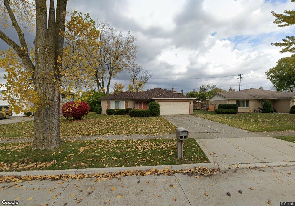
20330 Roseland St Southfield, MI 48076
Estimated Value: $314,000 - $431,000
3
Beds
3
Baths
2,129
Sq Ft
$164/Sq Ft
Est. Value
About This Home
This home is located at 20330 Roseland St, Southfield, MI 48076 and is currently estimated at $350,103, approximately $164 per square foot. 20330 Roseland St is a home located in Oakland County with nearby schools including Alice M. Birney K-8 School, Yeshivas Darchei Torah, and Farber Hebrew Day School.
Ownership History
Date
Name
Owned For
Owner Type
Purchase Details
Closed on
Aug 21, 2014
Sold by
Butler Theresa Anne and Greenway Theresa
Bought by
Butler Theresa Anne and Carethers Eleanor Margaret
Current Estimated Value
Purchase Details
Closed on
Sep 30, 1999
Sold by
Carethers James L
Bought by
Anthony Carethers Tr
Purchase Details
Closed on
Jun 21, 1996
Sold by
Greater Detroit Bidco In
Bought by
Carethers James L
Purchase Details
Closed on
Sep 19, 1994
Sold by
Dallo Yousef
Bought by
Thomas Keith A
Create a Home Valuation Report for This Property
The Home Valuation Report is an in-depth analysis detailing your home's value as well as a comparison with similar homes in the area
Home Values in the Area
Average Home Value in this Area
Purchase History
| Date | Buyer | Sale Price | Title Company |
|---|---|---|---|
| Butler Theresa Anne | -- | None Available | |
| Anthony Carethers Tr | -- | -- | |
| Carethers James L | $145,000 | -- | |
| Thomas Keith A | $133,000 | -- |
Source: Public Records
Mortgage History
| Date | Status | Borrower | Loan Amount |
|---|---|---|---|
| Closed | Thomas Keith A | -- |
Source: Public Records
Tax History Compared to Growth
Tax History
| Year | Tax Paid | Tax Assessment Tax Assessment Total Assessment is a certain percentage of the fair market value that is determined by local assessors to be the total taxable value of land and additions on the property. | Land | Improvement |
|---|---|---|---|---|
| 2022 | $3,565 | $133,090 | $18,110 | $114,980 |
| 2021 | $3,673 | $114,940 | $18,110 | $96,830 |
| 2020 | $3,199 | $102,240 | $15,750 | $86,490 |
| 2018 | $3,785 | $84,230 | $15,750 | $68,480 |
| 2015 | -- | $64,660 | $0 | $0 |
| 2014 | -- | $55,570 | $0 | $0 |
| 2011 | -- | $55,660 | $0 | $0 |
Source: Public Records
Map
Nearby Homes
- 28801 Ranchwood Dr
- 20351 Lacrosse Ave
- 20141 Lacrosse Ave
- 28450 Tapert Dr
- 29120 Evergreen Rd Unit 17
- 28430 Ranchwood Dr
- 29230 Bermuda Ln
- 20120 Covington Pkwy
- 19601 W 12 Mile Rd Unit 102
- 27925 Arlington Dr
- 29585 Woodhaven Ln
- 20780 Wayland St
- 20345 Harbor Ln
- 29662 Westbrook Pkwy
- 21440 Constitution St
- 21650 W 11 Mile Rd
- 18797 Wiltshire Blvd
- 29140 Candlewood Ln
- 27430 Evergreen Rd Unit 36
- 29743 Chelmsford Rd
- 20350 Roseland St
- 20320 Roseland St
- 20307 W 12 Mile Rd
- 20360 Roseland St
- 20300 Roseland St
- 20337 Roseland St
- 20325 Roseland St
- 20311 Roseland St
- 20355 Roseland St
- 20390 Roseland St
- 20371 Roseland St
- 20280 Roseland St
- 20295 Roseland St
- 20260 Roseland St
- 20420 Roseland St
- 20387 Roseland St
- 20281 Roseland St
- 20403 Roseland St
- 20320 Alhambra St
- 20265 Roseland St