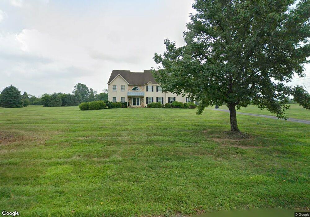
2034 Hollis Rd Lansdale, PA 19446
Estimated Value: $940,804 - $1,014,000
4
Beds
3
Baths
4,016
Sq Ft
$243/Sq Ft
Est. Value
About This Home
This home is located at 2034 Hollis Rd, Lansdale, PA 19446 and is currently estimated at $975,201, approximately $242 per square foot. 2034 Hollis Rd is a home located in Montgomery County with nearby schools including Worcester Elementary School, Skyview Upper Elementary School, and Arcola Intermediate School.
Ownership History
Date
Name
Owned For
Owner Type
Purchase Details
Closed on
Jul 30, 1993
Bought by
Schneider Bernard M
Current Estimated Value
Create a Home Valuation Report for This Property
The Home Valuation Report is an in-depth analysis detailing your home's value as well as a comparison with similar homes in the area
Home Values in the Area
Average Home Value in this Area
Purchase History
| Date | Buyer | Sale Price | Title Company |
|---|---|---|---|
| Schneider Bernard M | $387,900 | -- |
Source: Public Records
Tax History Compared to Growth
Tax History
| Year | Tax Paid | Tax Assessment Tax Assessment Total Assessment is a certain percentage of the fair market value that is determined by local assessors to be the total taxable value of land and additions on the property. | Land | Improvement |
|---|---|---|---|---|
| 2025 | $12,966 | $342,310 | $132,090 | $210,220 |
| 2024 | $12,966 | $342,310 | $132,090 | $210,220 |
| 2023 | $12,436 | $342,310 | $132,090 | $210,220 |
| 2022 | $12,196 | $342,310 | $132,090 | $210,220 |
| 2021 | $11,955 | $342,310 | $132,090 | $210,220 |
| 2020 | $11,733 | $342,310 | $132,090 | $210,220 |
| 2019 | $11,619 | $342,310 | $132,090 | $210,220 |
| 2018 | $1,335 | $342,310 | $132,090 | $210,220 |
| 2017 | $11,173 | $342,310 | $132,090 | $210,220 |
| 2016 | $11,039 | $342,310 | $132,090 | $210,220 |
| 2015 | $10,646 | $342,310 | $132,090 | $210,220 |
| 2014 | $10,646 | $342,310 | $132,090 | $210,220 |
Source: Public Records
Map
Nearby Homes
- 1811 Hollow Rd
- 3180 Zacharias Rd
- 3053 Sunny Ayre Dr
- 557 Broxton Ct
- 3235 Heebner Rd
- 1825 Flintlock Cir
- LOT 28 Heebner Rd
- 592 Blackmoor Ct
- 1939 Penngrove Terrace
- 205 Green Bank Way
- 0 Ashland Dr Unit PAMC2148822
- 1716 Landis Rd
- 1653 Bridle Path Dr
- 937 General Nash Dr
- 210 Berwick Place Unit 20E
- 128 Wellington Terrace
- 2203 Weber Rd
- 2806 Morris Rd
- 20 Township Line Rd
- 1116 Dogwood Ct
- 2031 Hollis Rd
- 2032 Hollis Rd
- 2036 Hollis Rd
- 2112 Bustard Rd
- 2035 Hollis Rd
- 2030 Hollis Rd
- 2038 Hollis Rd
- 3265 Barley Ln
- 2108 Bustard Rd
- 2033 Hollis Rd
- 2037 Hollis Rd
- 2028 Hollis Rd
- 2040 Hollis Rd
- 2039 Hollis Rd
- 2026 Hollis Rd
- 3268 Barley Ln
- 3272 Barley Ln
- 3264 Barley Ln
- 2042 Hollis Rd
- 2128 Bustard Rd