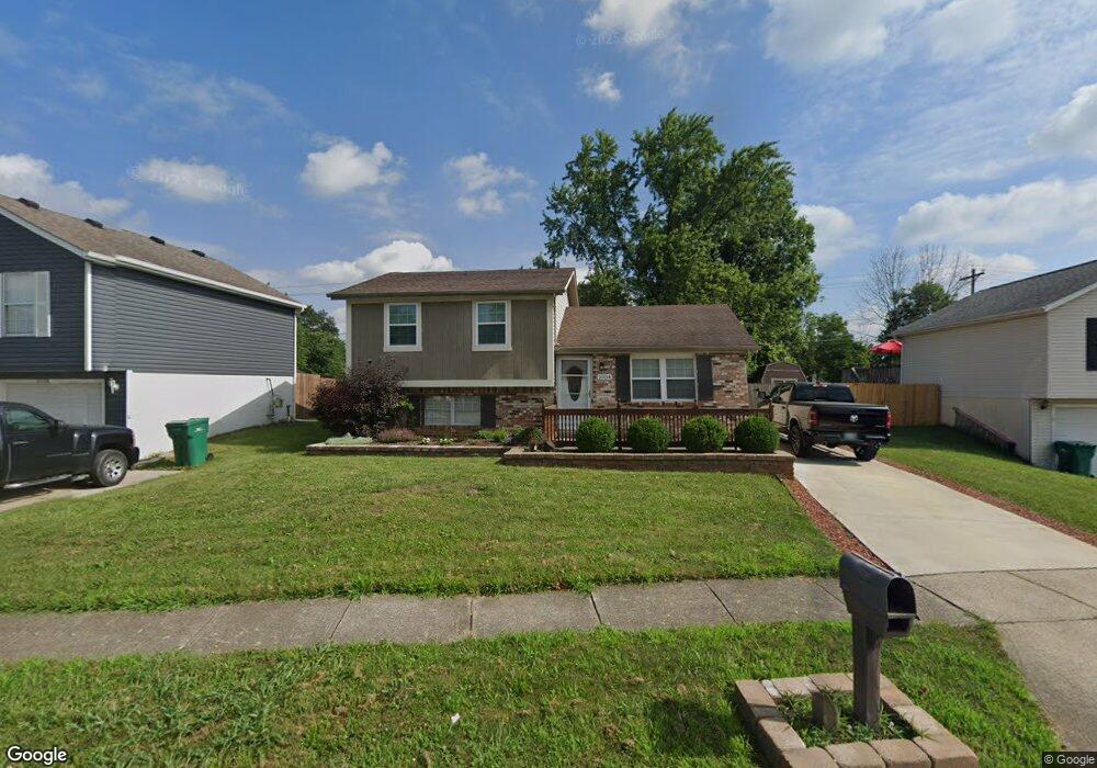
2034 Poplar St Obetz, OH 43207
Obetz-Lockbourne NeighborhoodEstimated Value: $223,094 - $254,000
4
Beds
2
Baths
1,252
Sq Ft
$191/Sq Ft
Est. Value
About This Home
This home is located at 2034 Poplar St, Obetz, OH 43207 and is currently estimated at $238,774, approximately $190 per square foot. 2034 Poplar St is a home located in Franklin County with nearby schools including Hamilton Elementary School, Hamilton Intermediate School, and Hamilton Middle School.
Ownership History
Date
Name
Owned For
Owner Type
Purchase Details
Closed on
Aug 25, 2003
Sold by
Davisson Earl Rodney and Davisson Jennifer A
Bought by
Dials Katherine A
Current Estimated Value
Home Financials for this Owner
Home Financials are based on the most recent Mortgage that was taken out on this home.
Original Mortgage
$99,216
Outstanding Balance
$45,170
Interest Rate
5.97%
Mortgage Type
FHA
Estimated Equity
$193,604
Purchase Details
Closed on
Jul 8, 1999
Sold by
Blair Michael O and Blair Henrietta
Bought by
Davisson Earl Rodney and Davisson Jennifer A
Purchase Details
Closed on
Oct 5, 1992
Purchase Details
Closed on
Mar 20, 1992
Create a Home Valuation Report for This Property
The Home Valuation Report is an in-depth analysis detailing your home's value as well as a comparison with similar homes in the area
Home Values in the Area
Average Home Value in this Area
Purchase History
| Date | Buyer | Sale Price | Title Company |
|---|---|---|---|
| Dials Katherine A | $100,000 | Esquire Title | |
| Davisson Earl Rodney | -- | -- | |
| -- | -- | -- | |
| -- | -- | -- |
Source: Public Records
Mortgage History
| Date | Status | Borrower | Loan Amount |
|---|---|---|---|
| Open | Dials Katherine A | $99,216 |
Source: Public Records
Tax History Compared to Growth
Tax History
| Year | Tax Paid | Tax Assessment Tax Assessment Total Assessment is a certain percentage of the fair market value that is determined by local assessors to be the total taxable value of land and additions on the property. | Land | Improvement |
|---|---|---|---|---|
| 2024 | $2,898 | $61,430 | $22,090 | $39,340 |
| 2023 | $2,854 | $61,425 | $22,085 | $39,340 |
| 2022 | $2,057 | $37,490 | $5,460 | $32,030 |
| 2021 | $2,085 | $37,490 | $5,460 | $32,030 |
| 2020 | $2,122 | $37,490 | $5,460 | $32,030 |
| 2019 | $1,907 | $29,960 | $4,340 | $25,620 |
| 2018 | $1,833 | $29,960 | $4,340 | $25,620 |
| 2017 | $1,839 | $29,960 | $4,340 | $25,620 |
| 2016 | $1,846 | $27,900 | $5,430 | $22,470 |
| 2015 | $1,753 | $27,900 | $5,430 | $22,470 |
| 2014 | $1,744 | $27,900 | $5,430 | $22,470 |
| 2013 | $934 | $30,975 | $6,020 | $24,955 |
Source: Public Records
Map
Nearby Homes
- 4310 Charlotte Rd
- 4383 Lancaster Ave
- 4417 Lancaster Ave
- 2222 Maureen Blvd S
- 2229 Maureen Blvd N
- 2318 Rodger Rd
- 4524 Sandridge St
- 1670 Marshall Ave
- 1640 Obetz Ave
- 1566 Chillicothe St
- 1632 Marlboro Ave
- 1624 Marlboro Ave
- 1559 Obetz Ave
- 0 Alum Creek Dr Unit 225007823
- 1456 Magoffin Ave
- 1510 Halfhill Way
- 1987 Reese Ave
- 2652 Millview Dr
- 3551 Groveport Rd
- 2715 Buggywhip Ln
- 2028 Poplar St
- 2042 Poplar St
- 2022 Poplar St
- 2050 Poplar St
- 2051 Poplar St
- 2045 Poplar St
- 2018-2020 Poplar St
- 2066 Poplar St
- 2018 Poplar St Unit 20
- 2057 Poplar St
- 2037 Poplar St
- 2029 Poplar St
- 2010=2012 Poplar
- 2010-2012 Poplar St Unit 12
- 2073 Poplar St
- 2010 Poplar St Unit 2012
- 2021 Poplar St
- 2039 Sedan Ave
- 2002-2004 Poplar St
- 2002-2004 Poplar St Unit 4