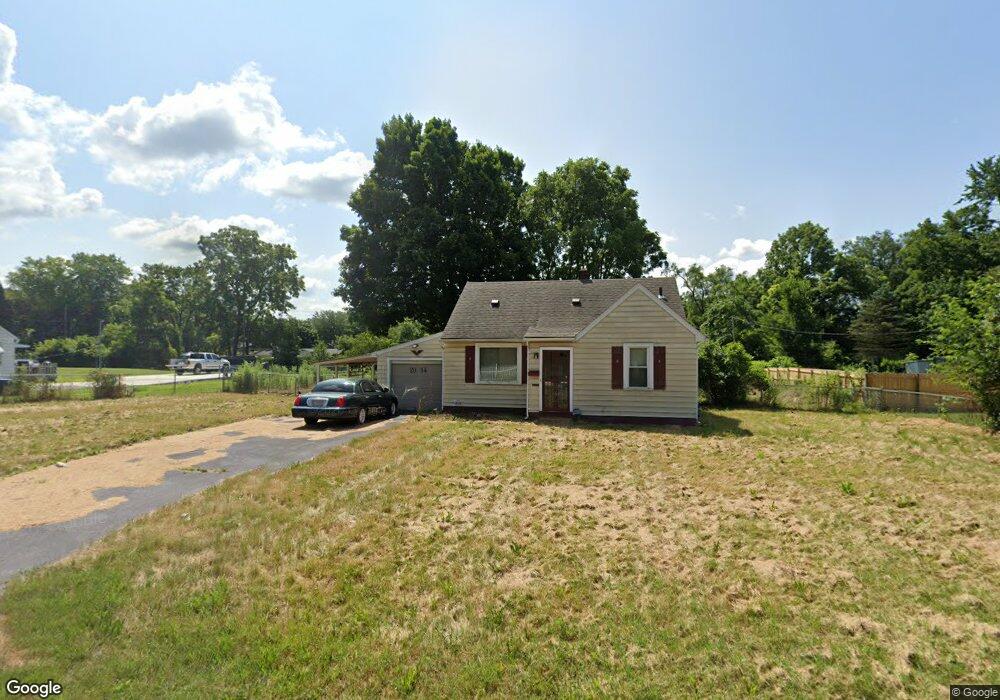
2034 Scioto St Springfield, OH 45506
Estimated Value: $144,400 - $180,000
3
Beds
1
Bath
1,067
Sq Ft
$148/Sq Ft
Est. Value
About This Home
This home is located at 2034 Scioto St, Springfield, OH 45506 and is currently estimated at $157,850, approximately $147 per square foot. 2034 Scioto St is a home located in Clark County with nearby schools including Possum Elementary School, Shawnee Middle School/High School, and Clark Preparatory Academy.
Ownership History
Date
Name
Owned For
Owner Type
Purchase Details
Closed on
Sep 27, 2019
Bought by
Roark Jack and Roark Mary
Current Estimated Value
Home Financials for this Owner
Home Financials are based on the most recent Mortgage that was taken out on this home.
Interest Rate
3.64%
Create a Home Valuation Report for This Property
The Home Valuation Report is an in-depth analysis detailing your home's value as well as a comparison with similar homes in the area
Home Values in the Area
Average Home Value in this Area
Purchase History
| Date | Buyer | Sale Price | Title Company |
|---|---|---|---|
| Roark Jack | $30,000 | -- |
Source: Public Records
Mortgage History
| Date | Status | Borrower | Loan Amount |
|---|---|---|---|
| Closed | Roark Jack | -- |
Source: Public Records
Tax History
| Year | Tax Paid | Tax Assessment Tax Assessment Total Assessment is a certain percentage of the fair market value that is determined by local assessors to be the total taxable value of land and additions on the property. | Land | Improvement |
|---|---|---|---|---|
| 2025 | $1,910 | $46,090 | $11,610 | $34,480 |
| 2024 | $1,862 | $37,300 | $8,170 | $29,130 |
| 2023 | $1,862 | $37,300 | $8,170 | $29,130 |
| 2022 | $1,847 | $37,300 | $8,170 | $29,130 |
| 2021 | $1,364 | $24,660 | $6,380 | $18,280 |
| 2020 | $1,375 | $24,660 | $6,380 | $18,280 |
| 2019 | $1,552 | $24,660 | $6,380 | $18,280 |
| 2018 | $1,289 | $22,880 | $6,720 | $16,160 |
| 2017 | $1,321 | $19,541 | $6,717 | $12,824 |
| 2016 | $1,193 | $19,541 | $6,717 | $12,824 |
| 2015 | $5,637 | $19,541 | $6,717 | $12,824 |
| 2014 | $1,133 | $19,541 | $6,717 | $12,824 |
| 2013 | $891 | $19,541 | $6,717 | $12,824 |
Source: Public Records
Map
Nearby Homes
- 2140 Shawnee Ave
- 1920 Russell Ave
- 2000 Springmont Ave
- 2301 Duquesne Dr
- 1109 Montgomery Ave
- 518 Hazelbrook Ave
- 550 W Parkwood Ave
- 929 S Western Ave
- 0 Montgomery Ave
- 1730 Damascus Ave
- 802 Innisfallen Ave
- 1002 S Yellow Springs St
- 506 W Southern Ave
- 830 Dibert Ave
- 405 W Southern Ave
- 2642 Springfield Xenia Rd
- 1207 W Pleasant St
- 1618 W Pleasant St
- 1230 W Pleasant St
- 311 W Grand Ave
- 2022 Scioto St
- 2108 Scioto St
- 2101 Duquesne Dr
- 2065 Duquesne Dr
- 2014 Scioto St
- 2122 Scioto St
- 2075 Scioto St
- 2055 Scioto St
- 2057 Duquesne Dr
- 2107 Duquesne Dr
- 2015 Scioto St
- 2117 Scioto St
- 2136 Scioto St
- 2115 Duquesne Dr
- 2051 Duquesne Dr
- 2002 Scioto St
- 2121 Duquesne Dr
- 2104 Duquesne Dr
- 2150 Scioto St
- 1353 Driscoll Ave
Your Personal Tour Guide
Ask me questions while you tour the home.