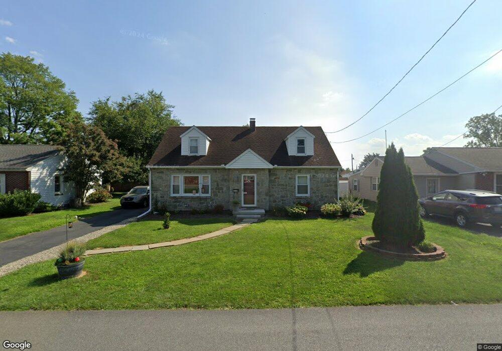
2034 Ursinus Ave Lancaster, PA 17603
Wheatland NeighborhoodEstimated Value: $299,000 - $351,000
4
Beds
1
Bath
1,692
Sq Ft
$192/Sq Ft
Est. Value
About This Home
This home is located at 2034 Ursinus Ave, Lancaster, PA 17603 and is currently estimated at $324,409, approximately $191 per square foot. 2034 Ursinus Ave is a home located in Lancaster County with nearby schools including Hambright Elementary School, Manor Middle School, and Penn Manor High School.
Ownership History
Date
Name
Owned For
Owner Type
Purchase Details
Closed on
Feb 29, 2008
Sold by
Kahl Christina L
Bought by
Roshon Christopher A and Mendez Paola J Montreuil
Current Estimated Value
Home Financials for this Owner
Home Financials are based on the most recent Mortgage that was taken out on this home.
Original Mortgage
$137,750
Outstanding Balance
$85,030
Interest Rate
5.57%
Mortgage Type
Purchase Money Mortgage
Estimated Equity
$239,379
Purchase Details
Closed on
Apr 13, 2006
Sold by
Kahl Christina L
Bought by
Kahl Christina L
Home Financials for this Owner
Home Financials are based on the most recent Mortgage that was taken out on this home.
Original Mortgage
$111,000
Interest Rate
6.37%
Mortgage Type
New Conventional
Create a Home Valuation Report for This Property
The Home Valuation Report is an in-depth analysis detailing your home's value as well as a comparison with similar homes in the area
Home Values in the Area
Average Home Value in this Area
Purchase History
| Date | Buyer | Sale Price | Title Company |
|---|---|---|---|
| Roshon Christopher A | $145,000 | Conestoga Title Insurance Co | |
| Kahl Christina L | -- | Lawyers Title |
Source: Public Records
Mortgage History
| Date | Status | Borrower | Loan Amount |
|---|---|---|---|
| Open | Roshon Christopher A | $137,750 | |
| Previous Owner | Kahl Christina L | $111,000 |
Source: Public Records
Tax History Compared to Growth
Tax History
| Year | Tax Paid | Tax Assessment Tax Assessment Total Assessment is a certain percentage of the fair market value that is determined by local assessors to be the total taxable value of land and additions on the property. | Land | Improvement |
|---|---|---|---|---|
| 2025 | $3,337 | $152,800 | $41,000 | $111,800 |
| 2024 | $3,337 | $152,800 | $41,000 | $111,800 |
| 2023 | $3,337 | $152,800 | $41,000 | $111,800 |
| 2022 | $3,274 | $152,800 | $41,000 | $111,800 |
| 2021 | $3,191 | $152,800 | $41,000 | $111,800 |
| 2020 | $3,191 | $152,800 | $41,000 | $111,800 |
| 2019 | $3,102 | $152,800 | $41,000 | $111,800 |
| 2018 | $2,386 | $152,800 | $41,000 | $111,800 |
| 2017 | $3,026 | $124,700 | $32,000 | $92,700 |
| 2016 | $3,026 | $124,700 | $32,000 | $92,700 |
| 2015 | $623 | $124,700 | $32,000 | $92,700 |
| 2014 | $2,077 | $124,700 | $32,000 | $92,700 |
Source: Public Records
Map
Nearby Homes
- 2008 Manor Ridge Dr
- 1799 Heritage Ave
- 1761 Wilson Ave
- 1809 Brubaker Run Rd
- 108 Wildbriar Ct S
- 619 + 621 Millersville Rd
- 220 Harvard Ave
- 105 Silverwind Ct S
- 109 Falcon Ct
- 34 Girard Ave
- 171 Harvard Ave
- 129 Joseph Rd
- 494 Northlawn Dr
- 114 Pheasant Ridge Cir
- 111 Pheasant Ridge Cir
- 203 Oakfield Ct W
- 106 Longwood Ct E
- 134 Bayberry Dr
- 2630 Columbia Ave
- 112 Whitney Rd
- 2028 Ursinus Ave
- 2040 Ursinus Ave
- 2039 Temple Ave
- 2022 Ursinus Ave
- 2029 Temple Ave
- 2041 Temple Ave
- 2046 Ursinus Ave
- 2023 Temple Ave
- 2016 Ursinus Ave
- 2045 Temple Ave
- 2017 Temple Ave
- 2048 Ursinus Ave
- 2008 Ursinus Ave
- 2049 Temple Ave
- 2009 Temple Ave
- 2030 Temple Ave
- 2040 Temple Ave
- 2048 Temple Ave
- 2026 Temple Ave
- 2001 Temple Ave