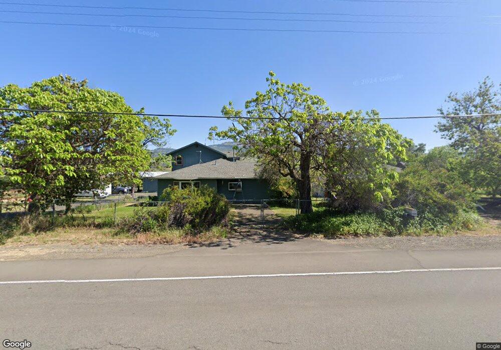
2035 E Main St Ashland, OR 97520
Estimated Value: $721,864 - $852,000
3
Beds
2
Baths
2,190
Sq Ft
$353/Sq Ft
Est. Value
About This Home
This home is located at 2035 E Main St, Ashland, OR 97520 and is currently estimated at $772,716, approximately $352 per square foot. 2035 E Main St is a home located in Jackson County with nearby schools including Bellview Elementary School, Ashland Middle School, and Ashland High School.
Ownership History
Date
Name
Owned For
Owner Type
Purchase Details
Closed on
Jul 23, 2019
Sold by
Cantrell Dina M and Cantrell Michael G
Bought by
Cantrell Michael Garen and Cantrell Dina Marie
Current Estimated Value
Purchase Details
Closed on
Feb 13, 1998
Sold by
Bamforth Bert and Bamforth Bruce W
Bought by
Cantrell Michael G and Cantrell Dina M
Purchase Details
Closed on
Apr 2, 1997
Sold by
Bamforth Albert E and Bamforth Betty W
Bought by
Bamforth Albert E and The Bamforth Revocable Trust
Purchase Details
Closed on
Jun 1, 1989
Sold by
Bamforth Albert E and Bamforth Betty W
Bought by
Cantrell Michael G and Cantrell Dina M
Create a Home Valuation Report for This Property
The Home Valuation Report is an in-depth analysis detailing your home's value as well as a comparison with similar homes in the area
Purchase History
| Date | Buyer | Sale Price | Title Company |
|---|---|---|---|
| Cantrell Michael Garen | -- | None Available | |
| Cantrell Michael G | $81,000 | Amerititle | |
| Bamforth Albert E | -- | -- | |
| Cantrell Michael G | -- | Amerititle |
Source: Public Records
Tax History
| Year | Tax Paid | Tax Assessment Tax Assessment Total Assessment is a certain percentage of the fair market value that is determined by local assessors to be the total taxable value of land and additions on the property. | Land | Improvement |
|---|---|---|---|---|
| 2026 | $2,801 | $189,094 | -- | -- |
| 2025 | $2,745 | $190,721 | $14,891 | $175,830 |
| 2024 | $2,745 | $185,287 | $14,577 | $170,710 |
| 2023 | $2,657 | $180,018 | $14,268 | $165,750 |
| 2022 | $2,572 | $180,018 | $14,268 | $165,750 |
| 2021 | $2,485 | $174,898 | $13,968 | $160,930 |
| 2020 | $2,416 | $169,920 | $13,680 | $156,240 |
| 2019 | $2,366 | $160,411 | $13,121 | $147,290 |
| 2018 | $2,237 | $155,859 | $12,859 | $143,000 |
| 2017 | $2,225 | $155,859 | $12,859 | $143,000 |
| 2016 | $2,175 | $147,149 | $12,349 | $134,800 |
| 2015 | $2,090 | $147,149 | $12,349 | $134,800 |
| 2014 | $1,982 | $138,934 | $11,864 | $127,070 |
Source: Public Records
Map
Nearby Homes
- 369 Meadow Dr
- 235 Meadow Dr
- 2221 Dollarhide Way
- 267 Meadow Dr
- 262 Meadow Dr
- 144 Crocker St
- 321 Clay St Unit SPC 3
- 215 Tolman Creek Rd Unit 31
- 215 Tolman Creek Rd Unit 16
- 215 Tolman Creek Rd Unit SPC 10
- 295 Tolman Creek Rd Unit 1
- 2205 Ashland St Unit 210
- 2082 E Main St
- 112 N Wightman St
- 139 N Wightman St
- 159 N Wightman St
- 2684 Clay Creek Way
- 740 Park St
- 510 Washington St
- 2729 Clay Creek Way
Your Personal Tour Guide
Ask me questions while you tour the home.