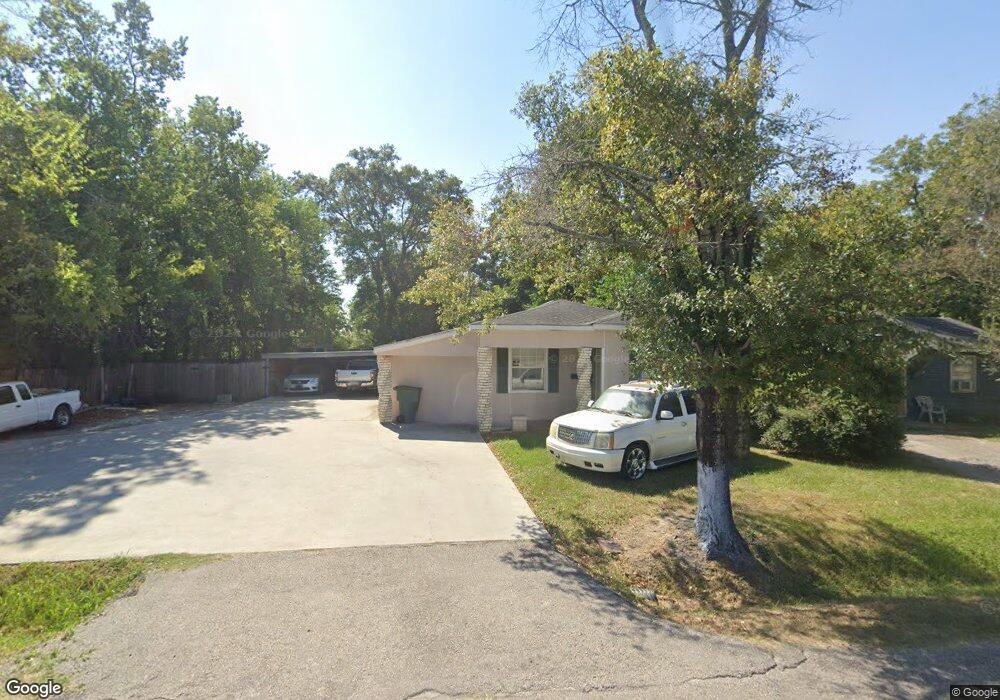
2035 Euclid St Beaumont, TX 77705
Pear Orchard NeighborhoodEstimated Value: $76,345 - $92,000
--
Bed
--
Bath
1,140
Sq Ft
$72/Sq Ft
Est. Value
About This Home
This home is located at 2035 Euclid St, Beaumont, TX 77705 and is currently estimated at $81,836, approximately $71 per square foot. 2035 Euclid St is a home located in Jefferson County with nearby schools including Blanchette Elementary School, Odom Middle School, and Beaumont United High School.
Ownership History
Date
Name
Owned For
Owner Type
Purchase Details
Closed on
Dec 16, 2020
Sold by
Mayfield Clayton Eugene and Estate Of Myrtle Mayfield Tarv
Bought by
Batiste Reginald
Current Estimated Value
Purchase Details
Closed on
Jul 30, 2012
Sold by
Breaux Geraldine
Bought by
Batiste Reginald
Purchase Details
Closed on
Feb 27, 2009
Sold by
Russell Ruby
Bought by
Breaux Geraldine
Purchase Details
Closed on
Oct 19, 2006
Sold by
Breauf Geraldine
Bought by
Russell Ruby S
Purchase Details
Closed on
Nov 11, 2004
Sold by
Fontenot Nancy
Bought by
Breaux Geraldine
Create a Home Valuation Report for This Property
The Home Valuation Report is an in-depth analysis detailing your home's value as well as a comparison with similar homes in the area
Home Values in the Area
Average Home Value in this Area
Purchase History
| Date | Buyer | Sale Price | Title Company |
|---|---|---|---|
| Batiste Reginald | -- | None Available | |
| Batiste Reginald | $2,000 | None Available | |
| Breaux Geraldine | $2,000 | None Available | |
| Russell Ruby S | $2,000 | None Available | |
| Breaux Geraldine | -- | -- |
Source: Public Records
Tax History Compared to Growth
Tax History
| Year | Tax Paid | Tax Assessment Tax Assessment Total Assessment is a certain percentage of the fair market value that is determined by local assessors to be the total taxable value of land and additions on the property. | Land | Improvement |
|---|---|---|---|---|
| 2025 | $449 | $40,554 | -- | -- |
| 2024 | $449 | $36,867 | -- | -- |
| 2023 | $449 | $33,515 | $0 | $0 |
| 2022 | $796 | $30,468 | $0 | $0 |
| 2021 | $937 | $34,529 | $1,176 | $33,353 |
| 2020 | $686 | $25,180 | $1,176 | $24,004 |
| 2019 | $704 | $25,190 | $1,180 | $24,010 |
| 2018 | $315 | $23,590 | $1,180 | $22,410 |
| 2017 | $306 | $23,590 | $1,180 | $22,410 |
| 2016 | $649 | $23,590 | $1,180 | $22,410 |
| 2015 | $413 | $23,590 | $1,180 | $22,410 |
| 2014 | $413 | $23,590 | $1,180 | $22,410 |
Source: Public Records
Map
Nearby Homes
- 1935 Euclid St
- 2430 Euclid St
- 2545 Euclid St
- 1830 Harriot St
- 2420 Harriot St
- 1780 Euclid St
- 2630 Harriot St
- 3435 Houston St
- 1725 Threadneedle St
- 1720 Elgie St
- 1925 Ollie St
- 2575 Potts St
- 2640 Euclid St
- 1920 May St
- 1598 Euclid St
- 1565 Church St
- 1555 Church St
- 1855 Cartwright St
- 3906 Lou St
- 1440 Euclid St
- 2045 Euclid St
- 1965 Euclid St
- 1955 Euclid St
- 1945 Euclid St
- 2085 Euclid St
- 2040 Harriot St
- 2050 Harriot St
- 1990 Harriot St
- 2070 Harriot St
- 2010 Euclid St
- 2095 Euclid St
- 1929 Euclid St
- 1980 Harriot St
- 1930 Euclid St
- 2060 Euclid
- 2060, 2062 Euclid
- 1920 Euclid St
- 1970 Harriot St
- 2080 Euclid St
- 2098 Harriot St