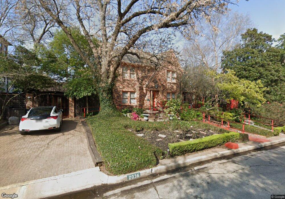
2036 Brentwood Dr Houston, TX 77019
Montrose NeighborhoodEstimated Value: $1,887,000 - $2,942,000
3
Beds
5
Baths
4,756
Sq Ft
$471/Sq Ft
Est. Value
About This Home
This home is located at 2036 Brentwood Dr, Houston, TX 77019 and is currently estimated at $2,239,009, approximately $470 per square foot. 2036 Brentwood Dr is a home located in Harris County with nearby schools including Baker Montessori, Lanier Middle School, and Lamar High School.
Ownership History
Date
Name
Owned For
Owner Type
Purchase Details
Closed on
Nov 10, 1997
Sold by
The Dowling Corp
Bought by
Ivins Ann Caraway
Current Estimated Value
Purchase Details
Closed on
Jul 15, 1996
Sold by
Aquilina Anthony J and Aquilina Lynda G
Bought by
Ivins James Leonard and Ivins Ann Caraway
Create a Home Valuation Report for This Property
The Home Valuation Report is an in-depth analysis detailing your home's value as well as a comparison with similar homes in the area
Home Values in the Area
Average Home Value in this Area
Purchase History
| Date | Buyer | Sale Price | Title Company |
|---|---|---|---|
| Ivins Ann Caraway | -- | -- | |
| Ivins James Leonard | -- | -- |
Source: Public Records
Tax History Compared to Growth
Tax History
| Year | Tax Paid | Tax Assessment Tax Assessment Total Assessment is a certain percentage of the fair market value that is determined by local assessors to be the total taxable value of land and additions on the property. | Land | Improvement |
|---|---|---|---|---|
| 2025 | $11,507 | $1,620,000 | $987,030 | $632,970 |
| 2024 | $11,507 | $1,520,571 | $987,030 | $533,541 |
| 2023 | $11,507 | $1,520,571 | $987,030 | $533,541 |
| 2022 | $12,080 | $1,471,220 | $937,679 | $533,541 |
| 2021 | $28,725 | $1,197,175 | $937,679 | $259,496 |
| 2020 | $28,991 | $1,197,175 | $937,679 | $259,496 |
| 2019 | $30,294 | $1,197,175 | $896,339 | $300,836 |
| 2018 | $12,906 | $1,197,175 | $707,636 | $489,539 |
| 2017 | $27,973 | $1,197,175 | $707,636 | $489,539 |
| 2016 | $25,430 | $1,197,175 | $707,636 | $489,539 |
| 2015 | $9,878 | $1,100,000 | $660,461 | $439,539 |
| 2014 | $9,878 | $1,245,674 | $613,285 | $632,389 |
Source: Public Records
Map
Nearby Homes
- 1216 S Shepherd Dr
- 1201 Mcduffie St Unit 198
- 1025 S Shepherd Dr Unit 209
- 2116 Looscan Ln
- 2117 Chilton Rd
- 1005 S Shepherd Dr Unit 406
- 1005 S Shepherd Dr Unit 304
- 2131 Brentwood Dr
- 1601 S Shepherd Dr Unit 20
- 1601 S Shepherd Dr Unit 29
- 1601 S Shepherd Dr Unit 138
- 1509 Mcduffie St
- 2105 Del Monte Dr
- 2247 Chilton Rd
- 902 S Shepherd Dr
- 1606 Hazard St
- 2204 Inwood Dr
- 1510 Morse St
- 1937 W Clay St
- 1711 Huldy St Unit A
- 2042 Brentwood Dr
- 1201 S Shepherd Dr
- 2005 Brentwood Dr
- 1207 S Shepherd Dr
- 2050 Brentwood Dr
- 2007 Brentwood Dr
- 2009 Brentwood Dr
- 1211 S Shepherd Dr
- 2013 Brentwood Dr
- 2054 Brentwood Dr
- 1217 S Shepherd Dr
- 2017 Brentwood Dr
- 2021 Brentwood Dr
- 2058 Brentwood Dr
- 1219 S Shepherd Dr
- 1200 S Shepherd Dr
- 1206 S Shepherd Dr
- 3838 W Clay St
- 1107 Mcduffie St
- 1118 S Shepherd Dr