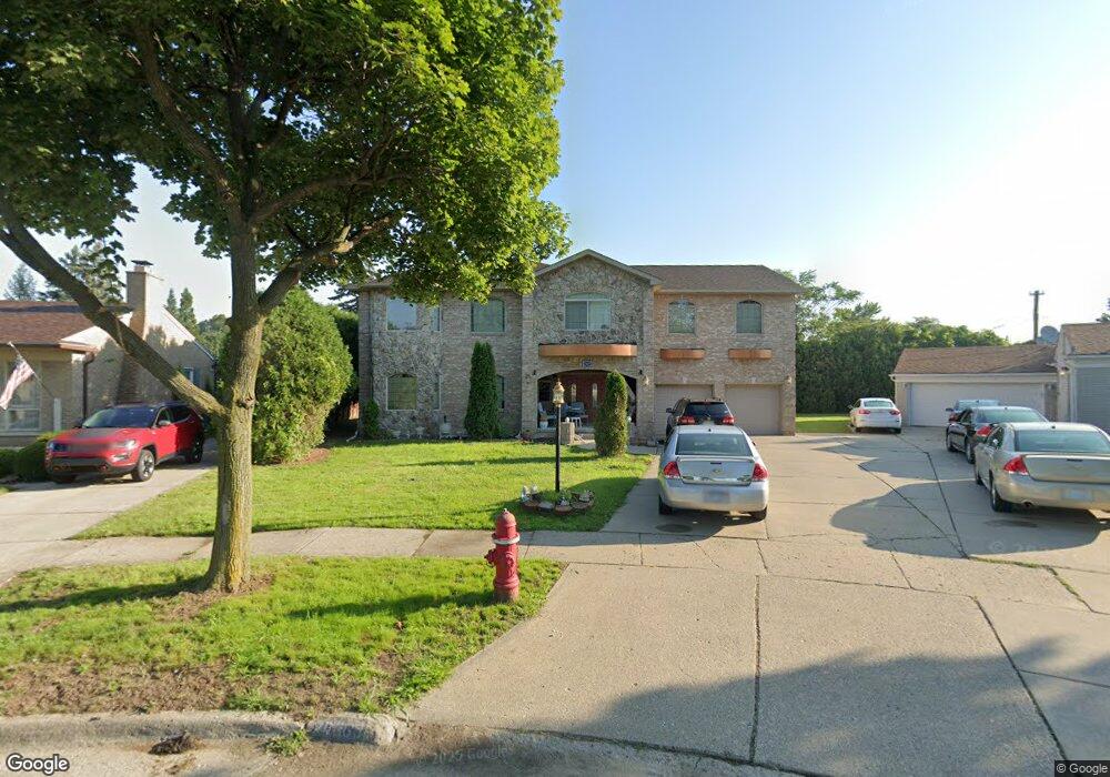
20368 Williamsburg Rd Dearborn Heights, MI 48127
Estimated Value: $622,000 - $975,000
5
Beds
4
Baths
3,800
Sq Ft
$210/Sq Ft
Est. Value
About This Home
This home is located at 20368 Williamsburg Rd, Dearborn Heights, MI 48127 and is currently estimated at $797,268, approximately $209 per square foot. 20368 Williamsburg Rd is a home located in Wayne County with nearby schools including River Oaks Elementary School, Bryant Middle School, and Dearborn High School.
Ownership History
Date
Name
Owned For
Owner Type
Purchase Details
Closed on
Jul 19, 2023
Sold by
Al-Jebori Fatima Mohammed-Habib and Al-Fanharawi Rukaya M
Bought by
Al-Jebori Fatima Mohammed-Hab
Current Estimated Value
Purchase Details
Closed on
Aug 3, 2020
Sold by
Noor Athmar A
Bought by
Al Jebori Fatima Mohammed Habib and Al Fanharawi Rukaya
Purchase Details
Closed on
Jun 23, 2011
Sold by
Al Fanharwi Mohamad and Al Jebori Fatima
Bought by
Noor Athmar A
Purchase Details
Closed on
Jul 31, 2001
Sold by
Kroll Denise
Bought by
Boussi Ibrahim G
Create a Home Valuation Report for This Property
The Home Valuation Report is an in-depth analysis detailing your home's value as well as a comparison with similar homes in the area
Home Values in the Area
Average Home Value in this Area
Purchase History
| Date | Buyer | Sale Price | Title Company |
|---|---|---|---|
| Al-Jebori Fatima Mohammed-Hab | -- | None Listed On Document | |
| Al Jebori Fatima Mohammed Habib | $170,000 | None Available | |
| Noor Athmar A | $165,000 | None Available | |
| Boussi Ibrahim G | $182,500 | -- |
Source: Public Records
Tax History Compared to Growth
Tax History
| Year | Tax Paid | Tax Assessment Tax Assessment Total Assessment is a certain percentage of the fair market value that is determined by local assessors to be the total taxable value of land and additions on the property. | Land | Improvement |
|---|---|---|---|---|
| 2025 | $16,116 | $418,082 | $0 | $0 |
| 2024 | $16,116 | $517,900 | $0 | $0 |
| 2023 | $14,300 | $452,200 | $0 | $0 |
| 2022 | $19,288 | $397,200 | $0 | $0 |
| 2021 | $21,600 | $367,100 | $0 | $0 |
| 2019 | $12,778 | $344,100 | $0 | $0 |
| 2018 | $8,270 | $275,400 | $0 | $0 |
| 2017 | $8,105 | $275,100 | $0 | $0 |
| 2016 | $9,994 | $254,900 | $0 | $0 |
| 2015 | $16,659 | $242,700 | $0 | $0 |
| 2013 | $16,138 | $175,200 | $0 | $0 |
| 2010 | -- | $187,700 | $0 | $0 |
Source: Public Records
Map
Nearby Homes
- 6078 Plainview Ave
- 6101 Auburn St
- 6367 Plainview Ave
- 6527 Vaughan St
- 6067 Minock St
- 6409 Auburn St
- 6319 Minock St
- 5836 Auburn St
- 6752 Heyden St
- 6717 Evergreen Rd
- 6219 Westwood St
- 6741 Evergreen Ave
- 5984 Campus Dr
- 6733 Plainview Ave
- 6843 Country Ln Unit 130
- 6782 Evergreen Ave
- 6816 Evergreen Ave
- 6881 Vaughan St
- 6267 Piedmont St
- 6837 Plainview Ave
- 20376 Williamsburg Rd
- 20360 Williamsburg Rd
- 20333 Brookwood St
- 20402 Williamsburg Rd
- 20317 Brookwood St
- 20348 Williamsburg Rd
- 20363 Brookwood St
- 20271 Brookwood St
- 20414 Williamsburg Rd
- 20377 Brookwood St
- 20336 Williamsburg Rd
- 20259 Brookwood St
- 20391 Brookwood St
- 20426 Williamsburg Rd
- 20243 Brookwood St
- 20369 Williamsburg Rd
- 20353 Williamsburg Rd
- 20254 Old Colony Rd
- 20411 Williamsburg Rd
- 20401 Brookwood St