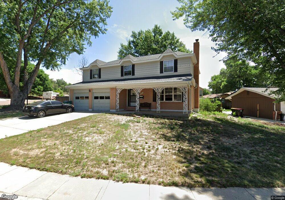
2037 Devon St Colorado Springs, CO 80909
Village Seven NeighborhoodEstimated Value: $475,183 - $607,000
4
Beds
2
Baths
2,870
Sq Ft
$182/Sq Ft
Est. Value
About This Home
This home is located at 2037 Devon St, Colorado Springs, CO 80909 and is currently estimated at $522,046, approximately $181 per square foot. 2037 Devon St is a home located in El Paso County with nearby schools including Madison Elementary School, Sabin Middle School, and Mitchell High School.
Ownership History
Date
Name
Owned For
Owner Type
Purchase Details
Closed on
Jul 8, 1998
Sold by
Noll Russell S and Noll Nancy A
Bought by
Culp Catherine R
Current Estimated Value
Home Financials for this Owner
Home Financials are based on the most recent Mortgage that was taken out on this home.
Original Mortgage
$107,125
Outstanding Balance
$22,075
Interest Rate
7.08%
Estimated Equity
$499,971
Purchase Details
Closed on
Jan 1, 1984
Bought by
Culp Catherine R
Create a Home Valuation Report for This Property
The Home Valuation Report is an in-depth analysis detailing your home's value as well as a comparison with similar homes in the area
Home Values in the Area
Average Home Value in this Area
Purchase History
| Date | Buyer | Sale Price | Title Company |
|---|---|---|---|
| Culp Catherine R | $214,250 | First American | |
| Culp Catherine R | -- | -- |
Source: Public Records
Mortgage History
| Date | Status | Borrower | Loan Amount |
|---|---|---|---|
| Open | Culp Catherine R | $107,125 |
Source: Public Records
Tax History Compared to Growth
Tax History
| Year | Tax Paid | Tax Assessment Tax Assessment Total Assessment is a certain percentage of the fair market value that is determined by local assessors to be the total taxable value of land and additions on the property. | Land | Improvement |
|---|---|---|---|---|
| 2025 | $1,687 | $33,800 | -- | -- |
| 2024 | $1,203 | $34,800 | $5,490 | $29,310 |
| 2022 | $1,476 | $26,380 | $4,170 | $22,210 |
| 2021 | $1,601 | $27,140 | $4,290 | $22,850 |
| 2020 | $1,626 | $23,960 | $3,720 | $20,240 |
| 2019 | $1,617 | $23,960 | $3,720 | $20,240 |
| 2018 | $1,572 | $21,430 | $3,240 | $18,190 |
| 2017 | $1,489 | $21,430 | $3,240 | $18,190 |
| 2016 | $1,139 | $19,640 | $2,710 | $16,930 |
| 2015 | $1,134 | $19,640 | $2,710 | $16,930 |
| 2014 | $1,094 | $18,180 | $2,710 | $15,470 |
Source: Public Records
Map
Nearby Homes
- 2103 Greenwich Cir E
- 2030 Bryant Ave
- 4017 Loring Cir N
- 4011 Loring Cir N
- 2006 Devon St
- 2210 Greenwich Cir W
- 2215 Northglen Dr
- 2335 Zane Place
- 2021 N Academy Blvd
- 2219 Stratford Ln
- 3916 Constitution Ave
- The Cedar Plan at Paint Brush Hills
- The Grand Royal Plan at Paint Brush Hills
- The Garden Plan at Paint Brush Hills
- 4307 Valli Vista Rd
- 1927 N Academy Blvd
- 4310 Tipton Ct
- 2043 Sussex Ln
- 4516 Constitution Ave
- 4323 Roundtree Ct
- 2049 Devon St
- 2030 Northglen Dr
- 2026 Northglen Dr
- 2046 Devon St
- 2034 Devon St
- 2038 Devon St
- 2023 Devon St
- 2030 Devon St
- 2050 Devon St
- 2022 Northglen Dr
- 2026 Devon St
- 2054 Devon St
- 2021 Devon St
- 2102 Greenwich Cir W
- 2111 Bryant Ave
- 2107 Bryant Ave
- 2022 Devon St
- 2103 Bryant Ave
- 2018 Northglen Dr
- 2106 Greenwich Cir W