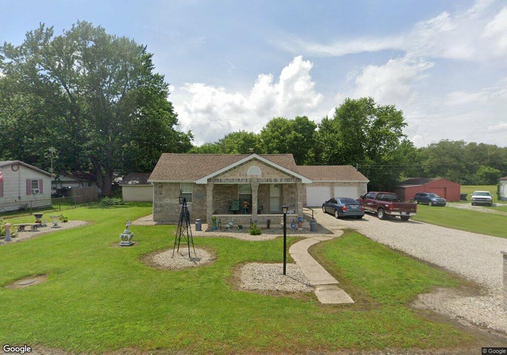
2037 State St Anderson, IN 46012
Estimated Value: $114,000 - $152,259
2
Beds
1
Bath
1,152
Sq Ft
$115/Sq Ft
Est. Value
About This Home
This home is located at 2037 State St, Anderson, IN 46012 and is currently estimated at $132,065, approximately $114 per square foot. 2037 State St is a home located in Madison County with nearby schools including Eastside Elementary School, Highland Middle School, and Anderson High School.
Ownership History
Date
Name
Owned For
Owner Type
Purchase Details
Closed on
May 14, 2021
Sold by
Rla Properties Llc
Bought by
Hatton Robert
Current Estimated Value
Purchase Details
Closed on
Jun 6, 2016
Sold by
Ayers Robert W
Bought by
Rla Properties Llc
Purchase Details
Closed on
Jun 19, 2012
Sold by
Hereditas Properties Llc
Bought by
Ayers Robert W
Purchase Details
Closed on
Mar 20, 2012
Sold by
Ayers Terence G
Bought by
Hereditas Properties Llc
Purchase Details
Closed on
Sep 26, 2011
Sold by
Allman Brenda A
Bought by
Ayers Terence G
Create a Home Valuation Report for This Property
The Home Valuation Report is an in-depth analysis detailing your home's value as well as a comparison with similar homes in the area
Home Values in the Area
Average Home Value in this Area
Purchase History
| Date | Buyer | Sale Price | Title Company |
|---|---|---|---|
| Hatton Robert | -- | None Available | |
| Rla Properties Llc | -- | -- | |
| Ayers Robert W | -- | None Available | |
| Hereditas Properties Llc | -- | None Available | |
| Ayers Terence G | $15,026 | None Available |
Source: Public Records
Tax History Compared to Growth
Tax History
| Year | Tax Paid | Tax Assessment Tax Assessment Total Assessment is a certain percentage of the fair market value that is determined by local assessors to be the total taxable value of land and additions on the property. | Land | Improvement |
|---|---|---|---|---|
| 2024 | $599 | $85,600 | $11,300 | $74,300 |
| 2023 | $548 | $78,400 | $10,700 | $67,700 |
| 2022 | $38 | $77,600 | $9,900 | $67,700 |
| 2021 | $569 | $68,800 | $9,700 | $59,100 |
| 2020 | $1,525 | $67,500 | $9,200 | $58,300 |
| 2019 | $1,407 | $65,800 | $9,200 | $56,600 |
| 2018 | $1,077 | $61,600 | $9,200 | $52,400 |
| 2017 | $1,108 | $55,400 | $9,200 | $46,200 |
| 2016 | $1,108 | $55,400 | $9,200 | $46,200 |
| 2014 | $1,086 | $54,300 | $9,200 | $45,100 |
| 2013 | $1,086 | $54,300 | $9,200 | $45,100 |
Source: Public Records
Map
Nearby Homes
- 2125 State St
- 2003 Crystal St
- 2132 Poplar St
- 2030 Broadway St
- 229 E Mulberry St
- 2334 Poplar St
- 143 E School St
- 305 Mohawk St
- 1611 Poplar St
- 2413 Silver St
- 2717 Apache Dr
- 724 Iroquois St
- 724 Iroquois Dr
- 135 Amber Dr
- 2722 Dakota Dr
- 2726 Apache Dr
- 0 E Cross St
- 0 E Cross St Unit LotWP001 24471664
- 718 Hawthorne Ave
- 1907 Lowell Ave