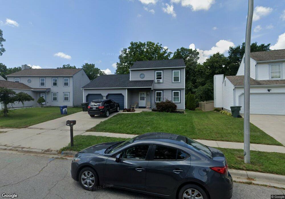
2039 Big Tree Dr Columbus, OH 43223
Estimated Value: $275,473 - $328,000
3
Beds
3
Baths
1,556
Sq Ft
$197/Sq Ft
Est. Value
About This Home
This home is located at 2039 Big Tree Dr, Columbus, OH 43223 and is currently estimated at $305,868, approximately $196 per square foot. 2039 Big Tree Dr is a home located in Franklin County with nearby schools including Finland Elementary School, Franklin Woods Intermediate School, and Finland Middle School.
Ownership History
Date
Name
Owned For
Owner Type
Purchase Details
Closed on
Jan 7, 2015
Sold by
Farris Eric W and Farris Amy L
Bought by
Farris Amy L
Current Estimated Value
Purchase Details
Closed on
Dec 31, 2008
Sold by
Johnson Curtis A and Johnson Carol A
Bought by
Farris Amy L
Home Financials for this Owner
Home Financials are based on the most recent Mortgage that was taken out on this home.
Original Mortgage
$111,069
Outstanding Balance
$71,867
Interest Rate
5.96%
Mortgage Type
FHA
Estimated Equity
$234,001
Purchase Details
Closed on
Nov 17, 1994
Sold by
Maronda Homes Inc
Bought by
Johnson Curtis A and Johnson Carol A
Home Financials for this Owner
Home Financials are based on the most recent Mortgage that was taken out on this home.
Original Mortgage
$82,400
Interest Rate
8.91%
Mortgage Type
New Conventional
Purchase Details
Closed on
Feb 11, 1994
Create a Home Valuation Report for This Property
The Home Valuation Report is an in-depth analysis detailing your home's value as well as a comparison with similar homes in the area
Home Values in the Area
Average Home Value in this Area
Purchase History
| Date | Buyer | Sale Price | Title Company |
|---|---|---|---|
| Farris Amy L | -- | None Available | |
| Farris Amy L | $113,000 | Attorney | |
| Johnson Curtis A | $99,400 | -- | |
| -- | $175,000 | -- |
Source: Public Records
Mortgage History
| Date | Status | Borrower | Loan Amount |
|---|---|---|---|
| Open | Farris Amy L | $111,069 | |
| Previous Owner | Johnson Curtis A | $82,400 |
Source: Public Records
Tax History
| Year | Tax Paid | Tax Assessment Tax Assessment Total Assessment is a certain percentage of the fair market value that is determined by local assessors to be the total taxable value of land and additions on the property. | Land | Improvement |
|---|---|---|---|---|
| 2025 | $3,177 | $87,120 | $21,390 | $65,730 |
| 2024 | $3,177 | $87,120 | $21,390 | $65,730 |
| 2023 | $3,120 | $87,115 | $21,385 | $65,730 |
| 2022 | $3,075 | $63,000 | $18,830 | $44,170 |
| 2021 | $3,136 | $63,000 | $18,830 | $44,170 |
| 2020 | $3,119 | $63,000 | $18,830 | $44,170 |
| 2019 | $2,763 | $49,250 | $15,050 | $34,200 |
| 2018 | $2,449 | $49,250 | $15,050 | $34,200 |
| 2017 | $2,442 | $49,250 | $15,050 | $34,200 |
| 2016 | $2,147 | $35,490 | $5,880 | $29,610 |
| 2015 | $2,147 | $35,490 | $5,880 | $29,610 |
| 2014 | $2,149 | $35,490 | $5,880 | $29,610 |
| 2013 | $1,123 | $37,380 | $6,195 | $31,185 |
Source: Public Records
Map
Nearby Homes
- 1543 Red Leaf Ln
- 1372 Stanwix Ct
- 1640 Butterfly Ct
- 2210 October Ridge Dr
- 2072 Asher Ct
- 1880 McDowell Ridge Dr
- 1521 October Ridge Ct
- 2248 Golden Leaf Ln
- 0 S Central Ave
- 1208 Woodbrook Ln Unit 307
- 1295 Woodbrook Ln Unit 223
- 2375 Woodbrook Cir N Unit 128
- 1258 Woodbrook Cir W Unit 199
- 2180 Eakin Rd
- 1257 Woodbrook Cir W Unit 15
- 1122 Harrisburg Pike
- 1532 Westmeadow Dr
- 2336 Woodbrook Cir N Unit 92 B
- 1417 Brown Rd
- 2362 Woodbrook Cir N Unit 81
- 2045 Big Tree Dr
- 2033 Big Tree Dr
- 2051 Big Tree Dr
- 2027 Big Tree Dr
- 2042 Big Tree Dr
- 2059 Big Tree Dr
- 2021 Big Tree Dr
- 2050 Big Tree Dr
- 1459 Ellicot Ct
- 2016 Big Tree Dr
- 2067 Big Tree Dr
- 2015 Big Tree Dr
- 2058 Big Tree Dr
- 2075 Big Tree Dr
- 1451 Ellicot Ct
- 2008 Big Tree Dr
- 1458 Ellicot Ct
- 2009 Big Tree Dr
- 1414 Buffalo Creek Ct
- 2160 Autumn Place
Your Personal Tour Guide
Ask me questions while you tour the home.