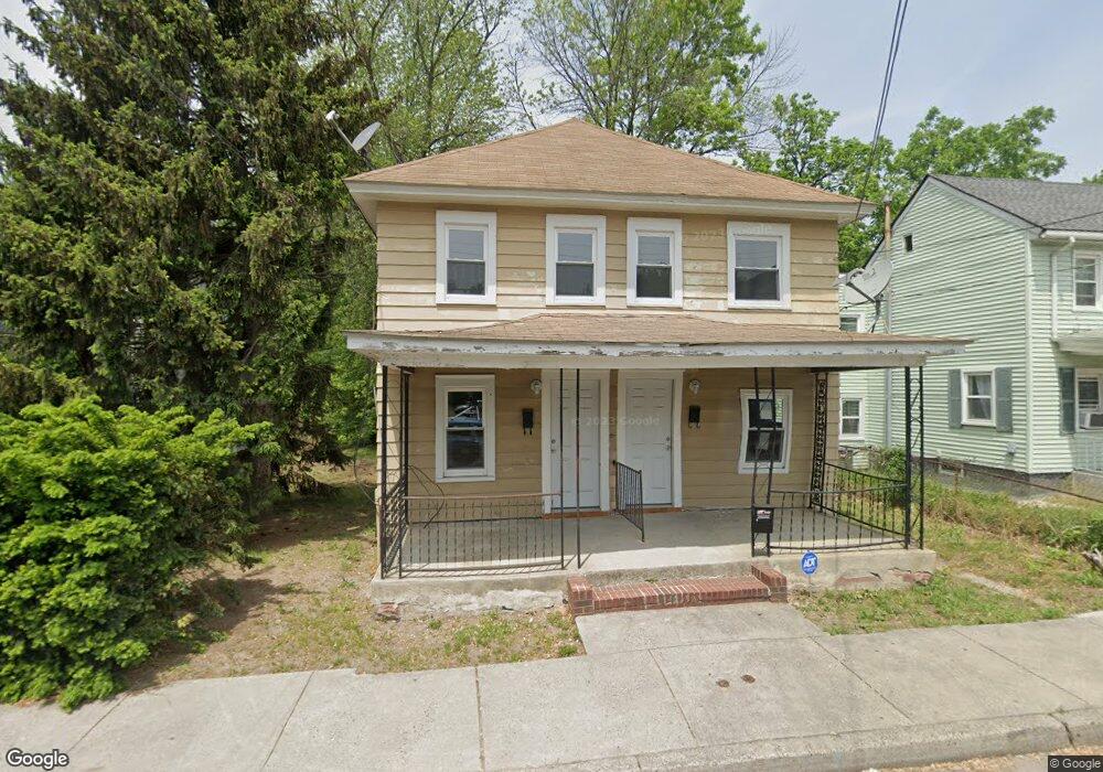
204-206 S Broad St Penns Grove, NJ 08069
Estimated Value: $196,820 - $267,000
3
Beds
1
Bath
1,920
Sq Ft
$125/Sq Ft
Est. Value
About This Home
This home is located at 204-206 S Broad St, Penns Grove, NJ 08069 and is currently estimated at $239,705, approximately $124 per square foot. 204-206 S Broad St is a home located in Salem County with nearby schools including Lafayette-Pershing Elementary School, Paul W. Carleton Elementary School, and Field Street Elementary School.
Ownership History
Date
Name
Owned For
Owner Type
Purchase Details
Closed on
Oct 29, 2020
Sold by
First Citizens Bank & Trust Company
Bought by
331 16Th Avenue Lola Dell Realty Llc
Current Estimated Value
Purchase Details
Closed on
Mar 9, 2020
Sold by
Apessos James and Dunn Debbie
Bought by
First Citizens Bank & Trust Company
Purchase Details
Closed on
Jul 30, 2009
Sold by
Hamilton Richard
Bought by
Apessos James and Dunn Debbie
Home Financials for this Owner
Home Financials are based on the most recent Mortgage that was taken out on this home.
Original Mortgage
$105,000
Interest Rate
5.36%
Mortgage Type
Purchase Money Mortgage
Purchase Details
Closed on
May 17, 2007
Sold by
Powell Isabella B Of
Bought by
Powell Kenneth H
Create a Home Valuation Report for This Property
The Home Valuation Report is an in-depth analysis detailing your home's value as well as a comparison with similar homes in the area
Home Values in the Area
Average Home Value in this Area
Purchase History
| Date | Buyer | Sale Price | Title Company |
|---|---|---|---|
| 331 16Th Avenue Lola Dell Realty Llc | $101,850 | Beacon Title Svcs Agcy Inc | |
| New Jersey Corporation | $101,850 | Beacon Title | |
| First Citizens Bank & Trust Company | -- | None Available | |
| Apessos James | $79,500 | -- | |
| Powell Kenneth H | -- | -- |
Source: Public Records
Mortgage History
| Date | Status | Borrower | Loan Amount |
|---|---|---|---|
| Previous Owner | Apessos James | $105,000 |
Source: Public Records
Tax History Compared to Growth
Tax History
| Year | Tax Paid | Tax Assessment Tax Assessment Total Assessment is a certain percentage of the fair market value that is determined by local assessors to be the total taxable value of land and additions on the property. | Land | Improvement |
|---|---|---|---|---|
| 2025 | $4,609 | $83,100 | $23,300 | $59,800 |
| 2024 | $4,454 | $83,100 | $23,300 | $59,800 |
| 2023 | $4,454 | $83,100 | $23,300 | $59,800 |
| 2022 | $4,294 | $83,100 | $23,300 | $59,800 |
| 2021 | $4,108 | $83,100 | $23,300 | $59,800 |
| 2020 | $4,162 | $83,100 | $23,300 | $59,800 |
| 2019 | $4,180 | $83,100 | $23,300 | $59,800 |
| 2018 | $4,280 | $106,100 | $20,300 | $85,800 |
| 2017 | $4,295 | $106,100 | $20,300 | $85,800 |
| 2016 | $4,133 | $106,100 | $20,300 | $85,800 |
| 2015 | $3,959 | $106,100 | $20,300 | $85,800 |
| 2014 | $3,915 | $106,100 | $20,300 | $85,800 |
Source: Public Records
Map
Nearby Homes
- 204 206 S Broad St
- 65 S Broad St
- 260 S Broad St
- 0 Park Ave Unit NJSA2013690
- 32 Westminster Ave
- 106 S Broad St
- 49 Delaware Dr
- 85 State St
- 15 Walnut St
- 0 Delaware Dr
- 106 Sack Ave
- 15 Spring St
- 32 Walnut St
- 55 57 Walnut St
- 59-61 Walnut St
- 80 S Broad St
- 213 Garnet St
- 83 Willis St
- 34 38 Cumberland Ave
- 114 Deming Ave
- 204 S Broad St Unit 206
- 206 S Broad St
- 200 S Broad St
- 210 S Broad St Unit 208
- 198 S Broad St
- 214 S Broad St
- 194 S Broad St
- 192 S Broad St
- 1 Helms Cove Ln
- 1 Helms Cove Ln
- 197 S Broad St Unit 199
- 197 S Broad St Unit 199
- 197 S Broad St
- 193 S Broad St
- 191 S Broad St
- 185 S Broad St
- 186 S Broad St
- 189 S Broad St
- 183 S Broad St
- 182 S Broad St