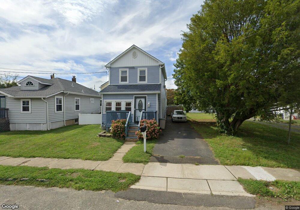
204 Coleman Ave Long Branch, NJ 07740
Estimated Value: $429,000 - $519,000
2
Beds
1
Bath
1,012
Sq Ft
$466/Sq Ft
Est. Value
About This Home
This home is located at 204 Coleman Ave, Long Branch, NJ 07740 and is currently estimated at $472,088, approximately $466 per square foot. 204 Coleman Ave is a home located in Monmouth County with nearby schools including Long Branch High School and Holy Trinity School.
Ownership History
Date
Name
Owned For
Owner Type
Purchase Details
Closed on
Jun 3, 1999
Sold by
Oreilly John
Bought by
Fiore Edward and Fiore Carol
Current Estimated Value
Home Financials for this Owner
Home Financials are based on the most recent Mortgage that was taken out on this home.
Original Mortgage
$68,400
Outstanding Balance
$18,248
Interest Rate
7.19%
Mortgage Type
FHA
Estimated Equity
$453,840
Create a Home Valuation Report for This Property
The Home Valuation Report is an in-depth analysis detailing your home's value as well as a comparison with similar homes in the area
Home Values in the Area
Average Home Value in this Area
Purchase History
| Date | Buyer | Sale Price | Title Company |
|---|---|---|---|
| Fiore Edward | $69,000 | -- |
Source: Public Records
Mortgage History
| Date | Status | Borrower | Loan Amount |
|---|---|---|---|
| Open | Fiore Edward | $68,400 |
Source: Public Records
Tax History
| Year | Tax Paid | Tax Assessment Tax Assessment Total Assessment is a certain percentage of the fair market value that is determined by local assessors to be the total taxable value of land and additions on the property. | Land | Improvement |
|---|---|---|---|---|
| 2025 | $6,071 | $422,500 | $248,000 | $174,500 |
| 2024 | $5,395 | $395,000 | $228,000 | $167,000 |
| 2023 | $5,395 | $347,400 | $188,000 | $159,400 |
| 2022 | $4,391 | $276,200 | $135,800 | $140,400 |
| 2021 | $4,391 | $232,100 | $100,800 | $131,300 |
| 2020 | $4,562 | $218,300 | $87,800 | $130,500 |
| 2019 | $4,378 | $208,300 | $83,800 | $124,500 |
| 2018 | $4,264 | $201,700 | $81,800 | $119,900 |
| 2017 | $4,068 | $197,400 | $79,800 | $117,600 |
| 2016 | $4,151 | $205,400 | $90,800 | $114,600 |
| 2015 | $3,216 | $144,400 | $63,500 | $80,900 |
| 2014 | $3,229 | $152,800 | $81,000 | $71,800 |
Source: Public Records
Map
Nearby Homes
- 401 Joline Ave
- 428 Atlantic Ave
- 516 Atlantic Ave
- 134 Lippincott Ave
- 117 Laurel St
- 139 Sixth Ave
- 267 N 5th Ave
- 275 N 5th Ave
- 282 Rockwell Ave
- 75 Washington St
- 631 Irving Place
- 395 Broadway
- 40 N 5th Ave
- 66 Seneca Place
- 68 Seneca Place
- 40 University Dr
- 448 Branchport Ave
- 25 Community Place
- 28 Morrell St
- 236 Seaview Ave
- 200 Coleman Ave
- 208 Coleman Ave
- 471 Pacific St
- 473 Pacific St
- 212 Coleman Ave
- 416 Pacific St
- 412 Pacific St
- 475 Pacific St
- 420 Pacific St
- 424 Pacific St
- 205 Coleman Ave
- 201 Coleman Ave
- 209 Coleman Ave
- 428 Pacific St
- 216 Coleman Ave
- 188 Coleman Ave
- 197 Coleman Ave
- 211 Coleman Ave
- 432 Pacific St
- 193 Coleman Ave
Your Personal Tour Guide
Ask me questions while you tour the home.