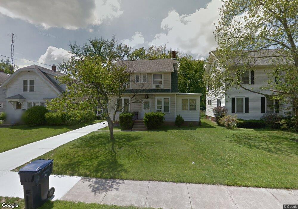
204 Euclid Ave Mansfield, OH 44903
Estimated Value: $156,000 - $192,000
3
Beds
1
Bath
2,002
Sq Ft
$87/Sq Ft
Est. Value
About This Home
This home is located at 204 Euclid Ave, Mansfield, OH 44903 and is currently estimated at $174,449, approximately $87 per square foot. 204 Euclid Ave is a home located in Richland County with nearby schools including Goal Digital Academy, Discovery School, and St. Peter's High School/Junior High.
Ownership History
Date
Name
Owned For
Owner Type
Purchase Details
Closed on
Sep 1, 1985
Current Estimated Value
Create a Home Valuation Report for This Property
The Home Valuation Report is an in-depth analysis detailing your home's value as well as a comparison with similar homes in the area
Home Values in the Area
Average Home Value in this Area
Purchase History
| Date | Buyer | Sale Price | Title Company |
|---|---|---|---|
| -- | $33,000 | -- |
Source: Public Records
Tax History Compared to Growth
Tax History
| Year | Tax Paid | Tax Assessment Tax Assessment Total Assessment is a certain percentage of the fair market value that is determined by local assessors to be the total taxable value of land and additions on the property. | Land | Improvement |
|---|---|---|---|---|
| 2024 | $1,822 | $38,870 | $4,160 | $34,710 |
| 2023 | $1,822 | $38,870 | $4,160 | $34,710 |
| 2022 | $1,590 | $28,410 | $3,570 | $24,840 |
| 2021 | $1,601 | $28,410 | $3,570 | $24,840 |
| 2020 | $1,637 | $28,410 | $3,570 | $24,840 |
| 2019 | $1,814 | $28,410 | $3,570 | $24,840 |
| 2018 | $1,789 | $28,410 | $3,570 | $24,840 |
| 2017 | $1,668 | $28,410 | $3,570 | $24,840 |
| 2016 | $1,594 | $25,220 | $4,920 | $20,300 |
| 2015 | $1,594 | $25,220 | $4,920 | $20,300 |
| 2014 | $1,503 | $25,220 | $4,920 | $20,300 |
| 2012 | $612 | $26,940 | $5,180 | $21,760 |
Source: Public Records
Map
Nearby Homes
- 191 Fairlawn Ave
- 118 Parkwood Blvd
- 143 Fairlawn Ave
- 679 Coleman Rd
- 135 Fairlawn Ave
- 129 Fairlawn Ave
- 212 Marlow Rd
- 133 Stewart Ave S
- 78 Glenwood Blvd
- 126 Dawson Ave
- 41 Parkwood Blvd
- 21 Glenwood Blvd
- 88 Sherman Ave
- 24 Stewart Ave S
- 190 S Linden Rd
- 616 Cline Ave
- 408 Fairlawn Ave
- 149 Bartley Ave
- 37 S Linden Rd
- 143 Kingwood Place
- 198 Euclid Ave
- 208 Euclid Ave
- 214 Euclid Ave
- 196 Euclid Ave
- 218 Euclid Ave
- 215 Euclid Ave
- 201 Euclid Ave
- 195 Mapledale Ave
- 700 Highland Ave
- 184 Euclid Ave
- 197 Euclid Ave
- 205 Euclid Ave
- 209 Euclid Ave
- 219 Euclid Ave
- 180 Euclid Ave
- 193 Mapledale Ave
- 189 Euclid Ave
- 202 Dolan Ct
- 202 Dolan Ct
- 654 Highland Ave