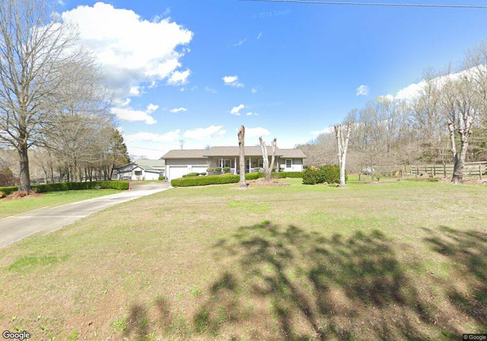
204 Hankins Rd Rock Spring, GA 30739
Rock Spring NeighborhoodEstimated Value: $227,253 - $299,000
--
Bed
2
Baths
1,391
Sq Ft
$193/Sq Ft
Est. Value
About This Home
This home is located at 204 Hankins Rd, Rock Spring, GA 30739 and is currently estimated at $269,063, approximately $193 per square foot. 204 Hankins Rd is a home located in Walker County with nearby schools including Rock Spring Elementary School, Lafayette High School, and Alice M Daley Adventist School.
Ownership History
Date
Name
Owned For
Owner Type
Purchase Details
Closed on
Jan 4, 2002
Sold by
Hamilton Mary Elizabeth
Bought by
Watkins Hoyt A and Watkins Barbara J
Current Estimated Value
Purchase Details
Closed on
Feb 6, 1998
Sold by
Hamilton Mary Elizabeth
Bought by
Hamilton Mary Elizabeth
Purchase Details
Closed on
May 29, 1996
Sold by
Hamilton E W
Bought by
Hamilton Mary Elizabeth
Purchase Details
Closed on
Jan 1, 1972
Bought by
Hamilton E W
Create a Home Valuation Report for This Property
The Home Valuation Report is an in-depth analysis detailing your home's value as well as a comparison with similar homes in the area
Home Values in the Area
Average Home Value in this Area
Purchase History
| Date | Buyer | Sale Price | Title Company |
|---|---|---|---|
| Watkins Hoyt A | -- | -- | |
| Hamilton Mary Elizabeth | $45,000 | -- | |
| Hamilton Mary Elizabeth | -- | -- | |
| Hamilton E W | -- | -- |
Source: Public Records
Tax History Compared to Growth
Tax History
| Year | Tax Paid | Tax Assessment Tax Assessment Total Assessment is a certain percentage of the fair market value that is determined by local assessors to be the total taxable value of land and additions on the property. | Land | Improvement |
|---|---|---|---|---|
| 2024 | $516 | $81,422 | $6,105 | $75,317 |
| 2023 | $440 | $76,345 | $4,741 | $71,604 |
| 2022 | $230 | $65,528 | $3,346 | $62,182 |
| 2021 | $139 | $48,492 | $3,346 | $45,146 |
| 2020 | $139 | $40,272 | $3,346 | $36,926 |
| 2019 | $139 | $40,272 | $3,346 | $36,926 |
| 2018 | $1,066 | $40,272 | $3,346 | $36,926 |
| 2017 | $1,047 | $40,272 | $3,346 | $36,926 |
| 2016 | $1,066 | $40,272 | $3,346 | $36,926 |
| 2015 | $725 | $24,852 | $4,576 | $20,276 |
| 2014 | $642 | $24,852 | $4,576 | $20,276 |
| 2013 | $1,066 | $24,851 | $4,576 | $20,275 |
Source: Public Records
Map
Nearby Homes
- 0 Cheshire Crossing Dr Unit 1387793
- 5602 Georgia 95
- 00 Georgia 95
- 0 Tarvin Rd Unit 1523862
- 0 E Teems Rd Unit 7573954
- 10180 Us Highway 27
- 1003 Highway N Old 27
- 449 W Watts Rd
- 1370 Old Highway 27
- 287 E Teems Rd
- 265 Rodeo Dr
- 15 Willow Cir
- 23 Willow Cir
- 16 Willow Cir
- 11 Willow Cir
- The Pearson Plan at Laurel Ridge
- The Benson II Plan at Laurel Ridge
- The Langford Plan at Laurel Ridge
- 227 Hankins Rd
- 290 Hankins Rd
- 226 Hankins Rd
- 135 Hankins Rd
- 87 Hankins Rd
- 105 Hankins Rd
- 389 Hankins Rd
- 144 Hankins Rd
- 2082 Highway 95
- 386 Hankins Rd
- 1978 Highway 95
- 433 Hankins Rd
- 2006 Highway 95
- 2416 Highway 95
- 3 Beaumont Rd
- 5 Beaumont Rd
- 2 Beaumont Rd
- 2262 Georgia 95
- 4 Beaumont Rd
- 2418 Highway 95