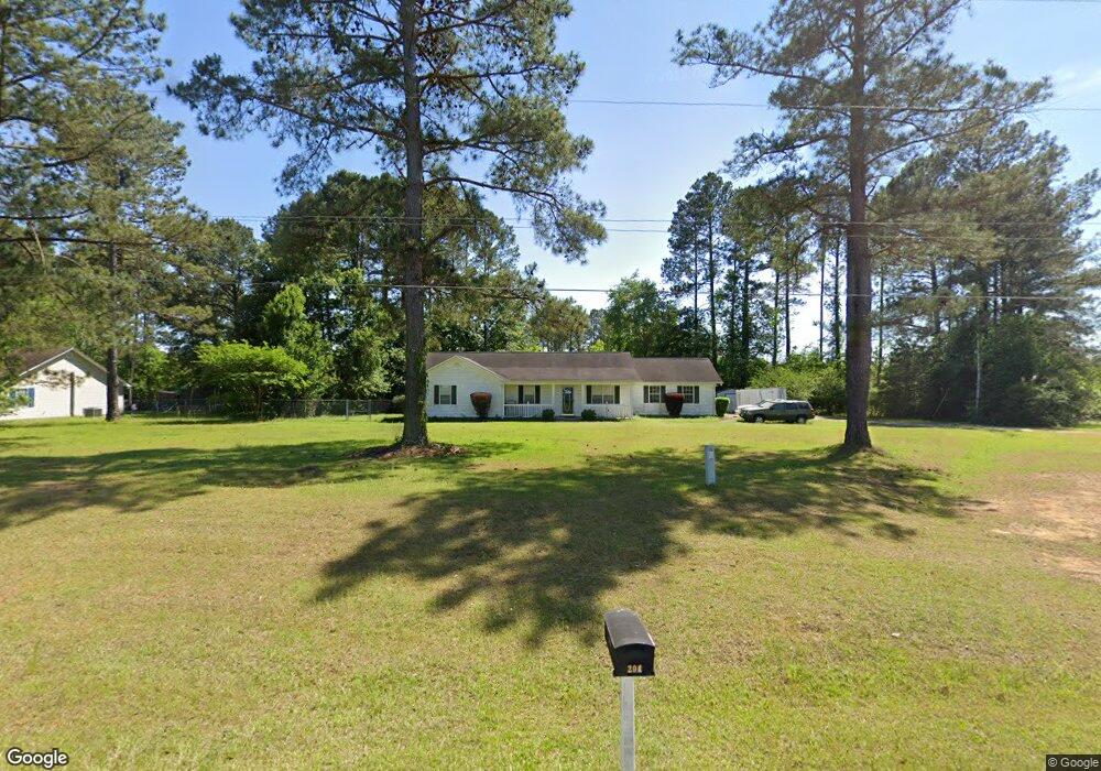
204 Morgan Rd East Dublin, GA 31027
Estimated Value: $182,950 - $222,000
3
Beds
2
Baths
1,505
Sq Ft
$135/Sq Ft
Est. Value
About This Home
This home is located at 204 Morgan Rd, East Dublin, GA 31027 and is currently estimated at $203,738, approximately $135 per square foot. 204 Morgan Rd is a home located in Laurens County with nearby schools including Northwest Laurens Elementary School, Southwest Laurens Elementary School, and East Laurens Primary School.
Ownership History
Date
Name
Owned For
Owner Type
Purchase Details
Closed on
Nov 21, 2003
Sold by
Lawson Angie H
Bought by
Lawson Angie H and Lawson Shannon K
Current Estimated Value
Purchase Details
Closed on
Mar 28, 2002
Sold by
Secretary Of Housing
Bought by
Lawson Angie H
Purchase Details
Closed on
Jan 2, 2001
Sold by
Fleet Mortgage Corp
Bought by
Secretary Of Housing
Purchase Details
Closed on
Apr 20, 1999
Sold by
Wilkerson Donny E
Bought by
Williams Sue
Purchase Details
Closed on
May 31, 1996
Sold by
Oconee Holding Co
Bought by
Wilkerson Donny E
Create a Home Valuation Report for This Property
The Home Valuation Report is an in-depth analysis detailing your home's value as well as a comparison with similar homes in the area
Home Values in the Area
Average Home Value in this Area
Purchase History
| Date | Buyer | Sale Price | Title Company |
|---|---|---|---|
| Lawson Angie H | -- | -- | |
| Lawson Angie H | $70,300 | -- | |
| Secretary Of Housing | $89,500 | -- | |
| Fleet Mortgage Corp | $89,500 | -- | |
| Williams Sue | $83,900 | -- | |
| Wilkerson Donny E | $6,300 | -- |
Source: Public Records
Tax History Compared to Growth
Tax History
| Year | Tax Paid | Tax Assessment Tax Assessment Total Assessment is a certain percentage of the fair market value that is determined by local assessors to be the total taxable value of land and additions on the property. | Land | Improvement |
|---|---|---|---|---|
| 2024 | $1,543 | $60,772 | $10,000 | $50,772 |
| 2023 | $1,334 | $53,934 | $10,000 | $43,934 |
| 2022 | $1,103 | $53,934 | $10,000 | $43,934 |
| 2021 | $748 | $36,286 | $2,784 | $33,502 |
| 2020 | $748 | $36,286 | $2,784 | $33,502 |
| 2019 | $749 | $36,286 | $2,784 | $33,502 |
| 2018 | $750 | $36,286 | $2,784 | $33,502 |
| 2017 | $749 | $36,286 | $2,784 | $33,502 |
| 2016 | $750 | $36,286 | $2,784 | $33,502 |
| 2015 | $750 | $36,286 | $2,784 | $33,502 |
| 2014 | $664 | $31,630 | $2,610 | $29,020 |
Source: Public Records
Map
Nearby Homes
- 0 Hillcrest Dr Unit 22383
- 330 Bradley Ct
- 103 Forest Ave
- 104 Long Pines Cir
- 174 Ernest Stinson Rd
- 437 Saint Charles Dr
- 445 Saint Charles Dr
- 0 Barnes Rd Unit 10511600
- 121 Coleman Ave
- 0 Glen Dr Unit 30353
- 0 Glen Dr Unit 10611123
- 0 Glen Dr Unit 30351
- 0 Glen Dr Unit 10611113
- 1328 Buckeye Rd
- 102 Circle Dr
- 335 Windsong Dr
- LOT 4 Wind Song Dr
- 00 Stoney Ridge Dr
- 0 Stoney Ridge Dr
- 00 Bridgemill Rd
- 202 Morgan Rd
- 320 Morgan Rd
- 106 Morgan Rd
- 292 Buckingham Parc Cir
- 104 Morgan Rd
- 288 Buckingham Parc Cir
- 1008 Wrightsville Ave
- 0 Buckingham Parc Cir Unit 8268323
- 0 Buckingham Park Unit 34 7472763
- 0 Buckingham Parc Cir Unit LOT 13 7408018
- 0 Buckingham Parc Cir Unit Lot 22 8030172
- 0 Buckingham Parc Cir Unit Lot 21 8030161
- 0 Buckingham Parc Cir Unit Lot 20 8030145
- 0 Buckingham Parc Cir Unit Lot 19 8030135
- 0 Buckingham Parc Cir Unit Lot 17 8030123
- 0 Buckingham Parc Cir Unit Lot 16 8030109
- 0 Buckingham Parc Cir Unit 22 8129833
- 0 Buckingham Parc Cir Unit 21 8129828
- 0 Buckingham Parc Cir Unit 20 8129809
- 0 Buckingham Parc Cir Unit 19 8129793