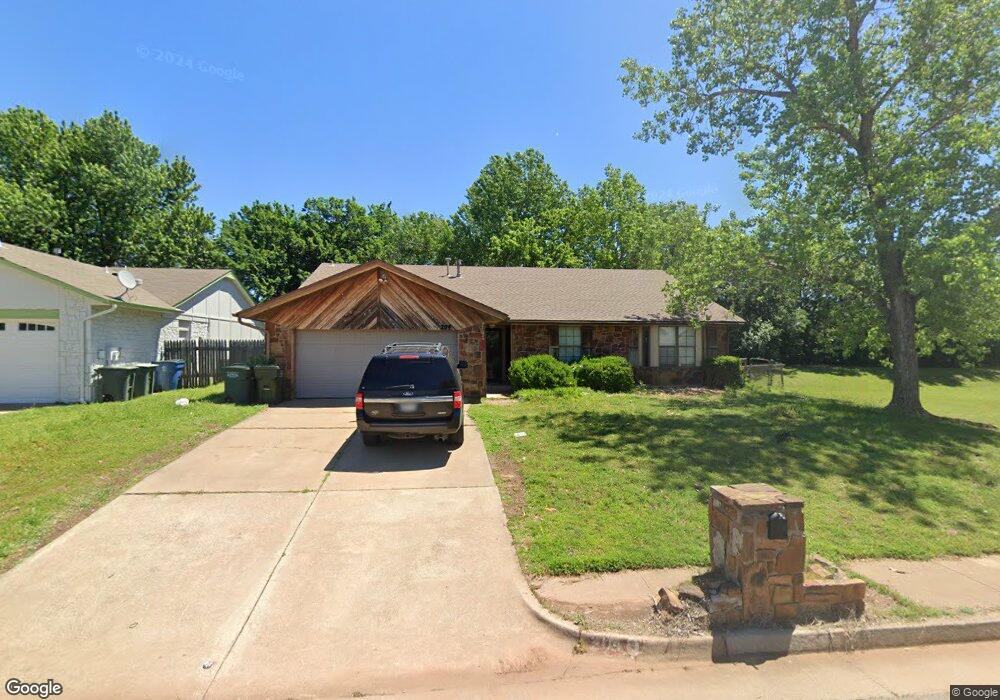
204 N Lockeport Dr Edmond, OK 73003
Oak Brook NeighborhoodEstimated Value: $223,000 - $253,000
3
Beds
2
Baths
1,792
Sq Ft
$134/Sq Ft
Est. Value
About This Home
This home is located at 204 N Lockeport Dr, Edmond, OK 73003 and is currently estimated at $239,801, approximately $133 per square foot. 204 N Lockeport Dr is a home located in Oklahoma County with nearby schools including Ida Freeman Elementary School, Cheyenne Middle School, and North High School.
Ownership History
Date
Name
Owned For
Owner Type
Purchase Details
Closed on
Jan 23, 2025
Sold by
In Touch Oklahoma Rs Llc
Bought by
204 N Lockeport Drive and Lda Holdings Llc
Current Estimated Value
Purchase Details
Closed on
Mar 26, 2014
Sold by
Barlor Danny R and Barlor Missy Denae
Bought by
In Touch Oklahoma Rs Llc
Purchase Details
Closed on
May 29, 2009
Sold by
Barlor Missy Denae and Chadwick Missy Denae
Bought by
Barlor Danny R and Barlor Missy Denae
Create a Home Valuation Report for This Property
The Home Valuation Report is an in-depth analysis detailing your home's value as well as a comparison with similar homes in the area
Home Values in the Area
Average Home Value in this Area
Purchase History
| Date | Buyer | Sale Price | Title Company |
|---|---|---|---|
| 204 N Lockeport Drive | -- | Legacy Title Of Oklahoma | |
| In Touch Oklahoma Rs Llc | $55,000 | Stewart Abstract & Title | |
| In Touch Oklahoma Rs Llc | $55,000 | None Available | |
| Barlor Danny R | -- | None Available |
Source: Public Records
Tax History Compared to Growth
Tax History
| Year | Tax Paid | Tax Assessment Tax Assessment Total Assessment is a certain percentage of the fair market value that is determined by local assessors to be the total taxable value of land and additions on the property. | Land | Improvement |
|---|---|---|---|---|
| 2024 | $2,164 | $21,793 | $2,992 | $18,801 |
| 2023 | $2,164 | $20,755 | $3,039 | $17,716 |
| 2022 | $2,068 | $19,767 | $3,264 | $16,503 |
| 2021 | $1,961 | $18,826 | $3,552 | $15,274 |
| 2020 | $1,890 | $17,930 | $3,247 | $14,683 |
| 2019 | $1,893 | $17,875 | $3,247 | $14,628 |
| 2018 | $1,887 | $17,710 | $0 | $0 |
| 2017 | $1,855 | $17,489 | $3,247 | $14,242 |
| 2016 | $1,839 | $17,379 | $3,153 | $14,226 |
| 2015 | $1,793 | $16,964 | $3,153 | $13,811 |
| 2014 | $1,716 | $16,253 | $3,153 | $13,100 |
Source: Public Records
Map
Nearby Homes
- 1824 Woody Ln
- 301 Bluegrass Ln
- 1725 Shady Ct
- 84 Kimberly Dr
- 2112 W Rockypoint Dr
- 2016 Emerald Brook Ct
- 613 Blue Ridge Dr
- 1821 Zion Place
- 781 N Santa fe Ave
- 109 Woodbridge Cir
- 2517 Antelope Cir
- 900 Blue Ridge Dr
- 1717 Rocky Mountain Way
- 1716 Glacier Ln
- 1632 Laurel Place
- 1308 Isabella Dr
- 1812 Foxfire Rd
- 1001 Glacier Ln
- 1804 Foxfire Rd
- 2604 Jeannes Trail
- 208 N Lockeport Dr
- 212 N Lockeport Dr
- 233 Kimberly Dr
- 241 Kimberly Dr
- 225 Kimberly Dr
- 205 N Lockeport Dr
- 209 N Lockeport Dr
- 249 Kimberly Dr
- 217 Kimberly Dr
- 124 N Lockeport Dr
- 216 N Lockeport Dr
- 213 N Lockeport Dr
- 133 N Lockeport Dr
- 301 Kimberly Dr
- 209 Kimberly Dr
- 116 N Lockeport Dr
- 125 N Lockeport Dr
- 217 N Lockeport Dr
- 200 N Grand Fork Dr
- 309 Kimberly Dr