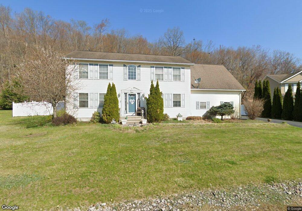
204 Raymond Dr Jermyn, PA 18433
Estimated Value: $143,338 - $407,000
--
Bed
--
Bath
--
Sq Ft
0.52
Acres
About This Home
This home is located at 204 Raymond Dr, Jermyn, PA 18433 and is currently estimated at $275,585. 204 Raymond Dr is a home with nearby schools including Valley View Intermediate School, Valley View Middle School, and Valley View High School.
Ownership History
Date
Name
Owned For
Owner Type
Purchase Details
Closed on
Oct 27, 2012
Sold by
Langenhop Frederick H and Langenhop Karen E
Bought by
Langenhop Karen E
Current Estimated Value
Create a Home Valuation Report for This Property
The Home Valuation Report is an in-depth analysis detailing your home's value as well as a comparison with similar homes in the area
Home Values in the Area
Average Home Value in this Area
Purchase History
| Date | Buyer | Sale Price | Title Company |
|---|---|---|---|
| Langenhop Karen E | -- | None Available |
Source: Public Records
Tax History Compared to Growth
Tax History
| Year | Tax Paid | Tax Assessment Tax Assessment Total Assessment is a certain percentage of the fair market value that is determined by local assessors to be the total taxable value of land and additions on the property. | Land | Improvement |
|---|---|---|---|---|
| 2025 | $5,403 | $21,000 | $6,950 | $14,050 |
| 2024 | $4,635 | $21,000 | $6,950 | $14,050 |
| 2023 | $4,635 | $21,000 | $6,950 | $14,050 |
| 2022 | $4,490 | $21,000 | $6,950 | $14,050 |
| 2021 | $4,480 | $21,000 | $6,950 | $14,050 |
| 2020 | $4,396 | $21,000 | $6,950 | $14,050 |
| 2019 | $4,077 | $21,000 | $6,950 | $14,050 |
| 2018 | $4,003 | $21,000 | $6,950 | $14,050 |
| 2017 | $3,982 | $21,000 | $6,950 | $14,050 |
| 2016 | $2,336 | $21,000 | $6,950 | $14,050 |
| 2015 | -- | $21,000 | $6,950 | $14,050 |
| 2014 | -- | $21,000 | $6,950 | $14,050 |
Source: Public Records
Map
Nearby Homes
- 0 Bacon St
- 441 Madison Ave
- 440 Washington Ave
- 0 Scranton Carbondale Hwy
- 0 Chestnut St
- 192 Shadow Wood Cir
- 880 Scranton - Carbondale
- 233 Shadow Wood Cir
- 815 Oak St
- 820 Oak St
- 426 Wildcat (Rt 247) Rd
- 723 Chestnut St
- 590 N Main St
- 0 Skyline Dr
- 9 Clayton Ln
- 1317 Heart Lake Rd
- 0 Forest Ln
- 210 Kennedy Dr
- 0 Ledgewood Dr
- 197 Columbus Dr
- 206 Raymond Dr
- 207 Raymond Dr
- 202 Raymond Dr
- 208 Raymond Dr
- 209 Raymond Dr
- 113 Raymond Dr
- 210 Raymond Dr
- 200 Raymond Dr
- 211 Raymond Dr
- 116 Raymond Dr Unit L12
- 111 Raymond Dr
- 212 Raymond Dr
- 0 Bacon & Alley St Unit GSBSC5144
- 0 Bacon & Alley St Unit GSB231927
- 0 Bacon & Alley St Unit GSBSC705
- 0 Route 6 Scr Cdale Hwy Unit 10-3317
- 0 Route 6 Scr Cdale Hwy Unit 10-3318
- 0 Route 6 Scr Cdale Hwy Unit 22-2273
- 114 Raymond Dr
- 0 Raymond 32 Dr