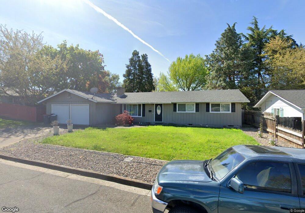
204 Victoria Way Central Point, OR 97502
Estimated Value: $350,000 - $365,000
3
Beds
3
Baths
1,504
Sq Ft
$238/Sq Ft
Est. Value
About This Home
This home is located at 204 Victoria Way, Central Point, OR 97502 and is currently estimated at $358,459, approximately $238 per square foot. 204 Victoria Way is a home located in Jackson County with nearby schools including Jewett Elementary School, Scenic Middle School, and Crater High School.
Ownership History
Date
Name
Owned For
Owner Type
Purchase Details
Closed on
Dec 21, 2011
Sold by
Lindsey Karl and Lindsey Linda R
Bought by
Allensworth Sarah N
Current Estimated Value
Home Financials for this Owner
Home Financials are based on the most recent Mortgage that was taken out on this home.
Original Mortgage
$124,755
Outstanding Balance
$85,012
Interest Rate
3.93%
Mortgage Type
FHA
Estimated Equity
$273,447
Purchase Details
Closed on
Nov 25, 2008
Sold by
Broderick Allen G
Bought by
Lindsey Karl and Lindsey Linda R
Home Financials for this Owner
Home Financials are based on the most recent Mortgage that was taken out on this home.
Original Mortgage
$201,537
Interest Rate
6.37%
Mortgage Type
FHA
Purchase Details
Closed on
Apr 25, 2008
Sold by
Broderick Allen G and Lindsey Karl L
Bought by
Broderick Allen G
Purchase Details
Closed on
Nov 27, 2007
Sold by
Broderick Allen G
Bought by
Broderick Allen G and Lindsey Karl L
Home Financials for this Owner
Home Financials are based on the most recent Mortgage that was taken out on this home.
Original Mortgage
$132,750
Interest Rate
6.42%
Mortgage Type
Purchase Money Mortgage
Purchase Details
Closed on
Oct 12, 2007
Sold by
Deutsche Bank Trust Co Americas
Bought by
Broderick Allen G
Home Financials for this Owner
Home Financials are based on the most recent Mortgage that was taken out on this home.
Original Mortgage
$132,750
Interest Rate
6.42%
Mortgage Type
Purchase Money Mortgage
Purchase Details
Closed on
Apr 10, 2007
Sold by
Latour Ronald C
Bought by
Deutsche Bank Trust Co Americas
Purchase Details
Closed on
Nov 4, 2004
Sold by
Perez Juan M and Perez Catherine M
Bought by
Latour Ronald C
Home Financials for this Owner
Home Financials are based on the most recent Mortgage that was taken out on this home.
Original Mortgage
$172,800
Interest Rate
8.37%
Mortgage Type
Stand Alone First
Purchase Details
Closed on
Jun 1, 1998
Sold by
Stong Catherine M
Bought by
Perez Juan M and Perez Catherine M
Create a Home Valuation Report for This Property
The Home Valuation Report is an in-depth analysis detailing your home's value as well as a comparison with similar homes in the area
Home Values in the Area
Average Home Value in this Area
Purchase History
| Date | Buyer | Sale Price | Title Company |
|---|---|---|---|
| Allensworth Sarah N | $128,000 | Ticor Title Company Oregon | |
| Lindsey Karl | $204,700 | First American Title | |
| Broderick Allen G | -- | None Available | |
| Broderick Allen G | -- | None Available | |
| Broderick Allen G | $177,000 | Fidelity Natl Title Co Of Or | |
| Deutsche Bank Trust Co Americas | $191,250 | None Available | |
| Latour Ronald C | $192,000 | Amerititle | |
| Perez Juan M | -- | -- |
Source: Public Records
Mortgage History
| Date | Status | Borrower | Loan Amount |
|---|---|---|---|
| Open | Allensworth Sarah N | $124,755 | |
| Previous Owner | Lindsey Karl | $201,537 | |
| Previous Owner | Broderick Allen G | $132,750 | |
| Previous Owner | Latour Ronald C | $172,800 |
Source: Public Records
Tax History Compared to Growth
Tax History
| Year | Tax Paid | Tax Assessment Tax Assessment Total Assessment is a certain percentage of the fair market value that is determined by local assessors to be the total taxable value of land and additions on the property. | Land | Improvement |
|---|---|---|---|---|
| 2025 | $3,138 | $188,760 | $100,680 | $88,080 |
| 2024 | $3,138 | $183,270 | $97,740 | $85,530 |
| 2023 | $3,037 | $177,940 | $94,900 | $83,040 |
| 2022 | $2,967 | $177,940 | $94,900 | $83,040 |
| 2021 | $2,882 | $172,760 | $92,140 | $80,620 |
| 2020 | $2,798 | $167,730 | $89,460 | $78,270 |
| 2019 | $2,729 | $158,110 | $84,320 | $73,790 |
| 2018 | $2,646 | $153,510 | $81,860 | $71,650 |
| 2017 | $2,579 | $153,510 | $81,860 | $71,650 |
| 2016 | $2,504 | $144,700 | $77,160 | $67,540 |
| 2015 | $2,399 | $144,700 | $77,160 | $67,540 |
| 2014 | $2,284 | $136,400 | $72,730 | $63,670 |
Source: Public Records
Map
Nearby Homes
- 1010 N 3rd St
- 4626 N Pacific Hwy
- 905 Comet Ave
- 920 N 10th St
- 4035 Rock Way
- 356 Marian Ave Unit 40
- 55 Crater Ln
- 327 Brookhaven Dr
- 741 Hazel St
- 342 Hazel St
- 833 Hazel St
- 1167 Boulder Ridge St
- 431 N 5th St
- 335 Applewood Dr
- 426 Bridge Creek Dr
- 405 N 9th St
- 0 Peninger Rd
- 526 Stone Pointe Dr
- 1159 Rustler Peak St
- 626 Griffin Oaks Dr
- 206 Victoria Way
- 1115 Crown Ave
- 203 Princess Way
- 208 Victoria Way
- 205 Princess Way
- 1101 Crown Ave
- 203 Victoria Way
- 1205 Crown Ave
- 205 Victoria Way
- 207 Princess Way
- 1120 Crown Ave
- 210 Victoria Way
- 207 Victoria Way
- 209 Princess Way
- 1209 Crown Ave Unit Lot11
- 1209 Crown Ave
- 1210 Crown Ave
- 110 Victoria St
- 110 Victoria Way
- 209 Victoria Way