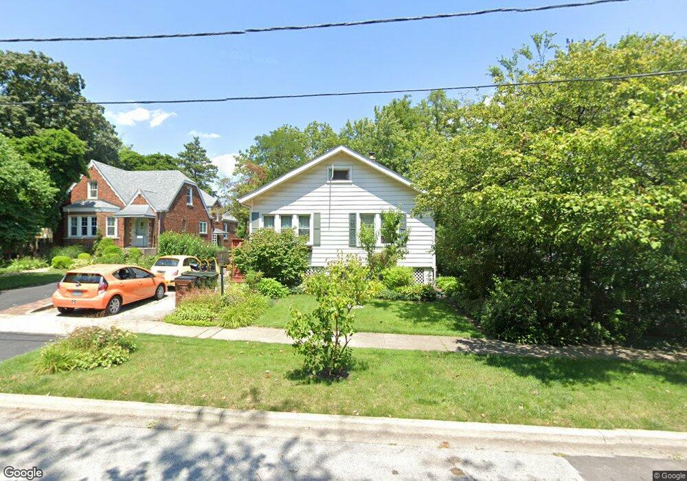
2040 Maple Rd Homewood, IL 60430
Estimated Value: $201,000 - $252,000
3
Beds
2
Baths
1,160
Sq Ft
$190/Sq Ft
Est. Value
About This Home
This home is located at 2040 Maple Rd, Homewood, IL 60430 and is currently estimated at $220,933, approximately $190 per square foot. 2040 Maple Rd is a home located in Cook County with nearby schools including Willow Elementary School, Winston Churchill School, and James Hart School.
Ownership History
Date
Name
Owned For
Owner Type
Purchase Details
Closed on
Jan 13, 1998
Sold by
Peckman Kurt and Peck Pamela L
Bought by
Harney Brian and Harney Kayoko
Current Estimated Value
Home Financials for this Owner
Home Financials are based on the most recent Mortgage that was taken out on this home.
Original Mortgage
$69,300
Outstanding Balance
$10,929
Interest Rate
7.24%
Estimated Equity
$210,004
Create a Home Valuation Report for This Property
The Home Valuation Report is an in-depth analysis detailing your home's value as well as a comparison with similar homes in the area
Home Values in the Area
Average Home Value in this Area
Purchase History
| Date | Buyer | Sale Price | Title Company |
|---|---|---|---|
| Harney Brian | $110,000 | -- |
Source: Public Records
Mortgage History
| Date | Status | Borrower | Loan Amount |
|---|---|---|---|
| Open | Harney Brian | $69,300 |
Source: Public Records
Tax History
| Year | Tax Paid | Tax Assessment Tax Assessment Total Assessment is a certain percentage of the fair market value that is determined by local assessors to be the total taxable value of land and additions on the property. | Land | Improvement |
|---|---|---|---|---|
| 2025 | $1,842 | $17,000 | $4,646 | $12,354 |
| 2024 | $1,842 | $17,000 | $4,646 | $12,354 |
| 2023 | $2,379 | $17,000 | $4,646 | $12,354 |
| 2022 | $2,379 | $10,592 | $4,027 | $6,565 |
| 2021 | $2,299 | $10,591 | $4,026 | $6,565 |
| 2020 | $2,425 | $10,591 | $4,026 | $6,565 |
| 2019 | $2,348 | $10,849 | $3,717 | $7,132 |
| 2018 | $2,267 | $10,849 | $3,717 | $7,132 |
| 2017 | $2,322 | $10,849 | $3,717 | $7,132 |
| 2016 | $2,917 | $10,155 | $3,407 | $6,748 |
| 2015 | $3,705 | $10,155 | $3,407 | $6,748 |
| 2014 | $3,661 | $10,155 | $3,407 | $6,748 |
| 2013 | $3,994 | $11,642 | $3,407 | $8,235 |
Source: Public Records
Map
Nearby Homes
- 2158 Cedar Rd
- 17833 Harwood Ave
- 17852 Howe Ave
- 17561 Hillside Ave
- 17640 Golfview Ave
- 1812 Cedar Rd
- 17563 Western Ave
- 18065 Harwood Ave Unit A
- 17308 Forestway Dr
- 18137 Martin Ave Unit 1NE
- 1624 Burr Oak Rd
- 1826 Sycamore Rd
- 17866 Ashland Ave
- 1621 Burr Oak Rd
- 17658 Lincoln Ave
- 2524 Locust Rd
- 2514 Spruce Rd
- 17917 Ashland Ave
- 17212 Hawthorne Dr
- 18241 Gottschalk Ave
- 2046 Maple Rd
- 2052 Maple Rd
- 2035 Maple Rd
- 2043 Maple Rd
- 2056 Maple Rd
- 17704 Dixie Hwy Unit 7
- 17704 Dixie Hwy Unit 6
- 17704 Dixie Hwy Unit 4
- 17704 Dixie Hwy Unit 1
- 17704 Dixie Hwy Unit 3
- 17704 Dixie Hwy Unit 5
- 17704 Dixie Hwy Unit 2
- 17704 Dixie Hwy Unit 8
- 17704 Dixie Hwy Unit 1A
- 17704 Dixie Hwy Unit 1D
- 17704 Dixie Hwy Unit 2C
- 17704 Dixie Hwy Unit 1B
- 2047 Maple Rd
- 2025 Maple Rd Unit 2E
- 2025 Maple Rd Unit 1W
Your Personal Tour Guide
Ask me questions while you tour the home.