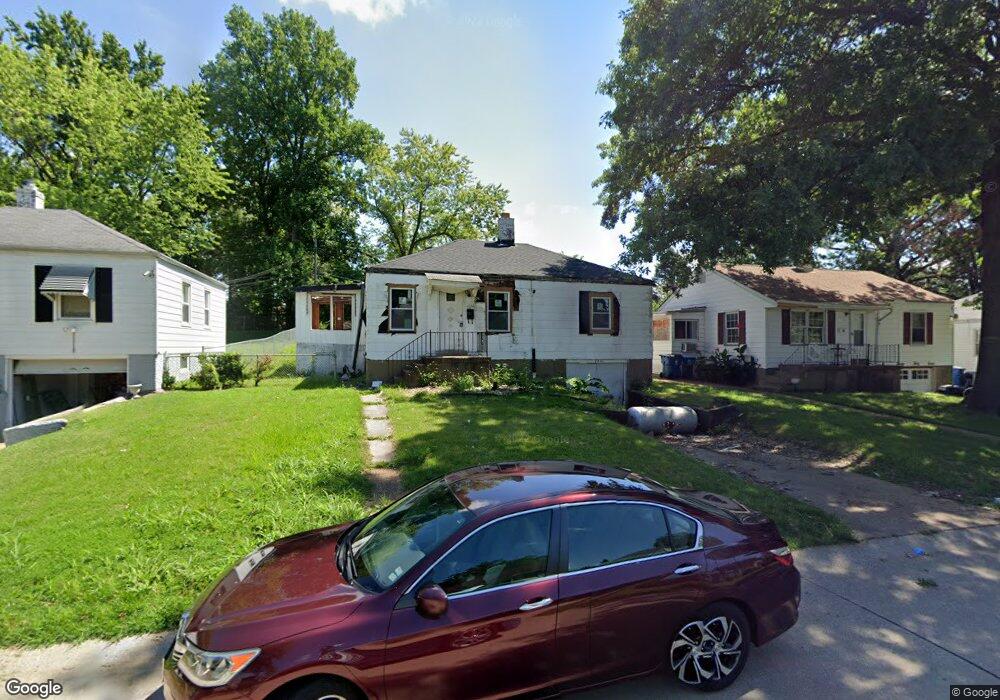
2041 Coleridge Dr Saint Louis, MO 63136
Estimated Value: $77,000 - $86,000
3
Beds
1
Bath
1,034
Sq Ft
$81/Sq Ft
Est. Value
About This Home
This home is located at 2041 Coleridge Dr, Saint Louis, MO 63136 and is currently estimated at $83,411, approximately $80 per square foot. 2041 Coleridge Dr is a home located in St. Louis County with nearby schools including Jennings Junior High School, Jennings High School, and St. Louis Unified School.
Ownership History
Date
Name
Owned For
Owner Type
Purchase Details
Closed on
May 17, 2022
Sold by
City Of Jennings Missouri
Bought by
Christian Selena
Current Estimated Value
Purchase Details
Closed on
Feb 22, 2022
Sold by
Collector Of Revenue St Louis County Mis
Bought by
City Of Jennings
Purchase Details
Closed on
Apr 21, 2000
Sold by
Alhalabi Mohamad Z and Alhalabi Brenda S
Bought by
Eagle Environmental Inc
Home Financials for this Owner
Home Financials are based on the most recent Mortgage that was taken out on this home.
Original Mortgage
$41,600
Interest Rate
8.24%
Purchase Details
Closed on
Mar 27, 2000
Sold by
Lee Fields Brandy and Elaine Connie
Bought by
Boyd Janice
Home Financials for this Owner
Home Financials are based on the most recent Mortgage that was taken out on this home.
Original Mortgage
$41,600
Interest Rate
8.24%
Create a Home Valuation Report for This Property
The Home Valuation Report is an in-depth analysis detailing your home's value as well as a comparison with similar homes in the area
Home Values in the Area
Average Home Value in this Area
Purchase History
| Date | Buyer | Sale Price | Title Company |
|---|---|---|---|
| Christian Selena | -- | None Listed On Document | |
| City Of Jennings | -- | None Listed On Document | |
| Eagle Environmental Inc | $52,000 | -- | |
| Boyd Janice | $46,000 | -- |
Source: Public Records
Mortgage History
| Date | Status | Borrower | Loan Amount |
|---|---|---|---|
| Previous Owner | Eagle Environmental Inc | $41,600 | |
| Previous Owner | Boyd Janice | $41,400 | |
| Closed | Boyd Janice | $2,100 |
Source: Public Records
Tax History Compared to Growth
Tax History
| Year | Tax Paid | Tax Assessment Tax Assessment Total Assessment is a certain percentage of the fair market value that is determined by local assessors to be the total taxable value of land and additions on the property. | Land | Improvement |
|---|---|---|---|---|
| 2025 | $1,310 | $13,850 | $1,920 | $11,930 |
| 2024 | $1,310 | $12,370 | $760 | $11,610 |
| 2023 | $1,299 | $12,370 | $760 | $11,610 |
| 2022 | $1,004 | $7,730 | $1,540 | $6,190 |
| 2021 | $989 | $7,730 | $1,540 | $6,190 |
| 2020 | $955 | $7,090 | $1,160 | $5,930 |
| 2019 | $936 | $7,090 | $1,160 | $5,930 |
| 2018 | $793 | $5,720 | $1,160 | $4,560 |
| 2017 | $760 | $5,720 | $1,160 | $4,560 |
| 2016 | $1,031 | $7,790 | $1,540 | $6,250 |
| 2015 | $1,027 | $7,790 | $1,540 | $6,250 |
| 2014 | $907 | $6,840 | $1,770 | $5,070 |
Source: Public Records
Map
Nearby Homes
- 2020 Wedgewood Dr
- 2056 Coleridge Dr
- 9223 Riverwood Dr
- 1973 Park Ln
- 9219 Sundown Dr
- 9108 Northcrest Ln
- 8917 Lucerne Ct
- 8791 Goodfellow Blvd
- 8769 Goodfellow Blvd
- 9422 Westchester Dr
- 1640 Grape Ave
- 8828 Riverview Blvd
- 8831 May Ave
- 8637 Drury Ln
- 9418 Pattonwood Dr
- 8622 Goodfellow Blvd
- 1236 Duenke Dr
- 1827 Switzer Ave
- 2006 McLaran Ave
- 8937 Edna St
- 2037 Coleridge Dr
- 2045 Coleridge Dr
- 2032 Ranchdale Dr
- 2033 Coleridge Dr
- 2049 Coleridge Dr
- 2028 Ranchdale Dr
- 2038 Ranchdale Dr
- 2029 Coleridge Dr
- 2053 Coleridge Dr
- 2024 Ranchdale Dr
- 2044 Coleridge Dr
- 2036 Coleridge Dr
- 2048 Coleridge Dr
- 2032 Coleridge Dr
- 2044 Ranchdale Dr
- 2020 Ranchdale Dr
- 2025 Coleridge Dr
- 2052 Coleridge Dr
- 2028 Coleridge Dr
- 2016 Ranchdale Dr