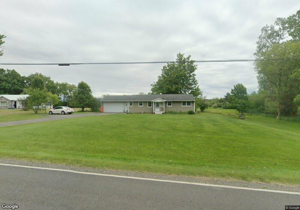
2041 Vandekarr Rd Owosso, MI 48867
Estimated Value: $187,000 - $229,000
3
Beds
2
Baths
1,298
Sq Ft
$158/Sq Ft
Est. Value
About This Home
This home is located at 2041 Vandekarr Rd, Owosso, MI 48867 and is currently estimated at $205,084, approximately $158 per square foot. 2041 Vandekarr Rd is a home located in Shiawassee County with nearby schools including Owosso High School, Salem Lutheran School, and St. Paul School.
Ownership History
Date
Name
Owned For
Owner Type
Purchase Details
Closed on
Feb 21, 2013
Sold by
Caswell Beverly
Bought by
Volk Mary J
Current Estimated Value
Home Financials for this Owner
Home Financials are based on the most recent Mortgage that was taken out on this home.
Original Mortgage
$97,589
Outstanding Balance
$68,125
Interest Rate
3.38%
Estimated Equity
$136,959
Purchase Details
Closed on
Sep 5, 2012
Sold by
Servicing Lp Bac Home Loans
Bought by
Caswell Beverly
Purchase Details
Closed on
Mar 2, 2011
Sold by
Fuller John D and Sprague Robin L
Bought by
Deutsche Bank National Trust Co
Create a Home Valuation Report for This Property
The Home Valuation Report is an in-depth analysis detailing your home's value as well as a comparison with similar homes in the area
Home Values in the Area
Average Home Value in this Area
Purchase History
| Date | Buyer | Sale Price | Title Company |
|---|---|---|---|
| Volk Mary J | $95,638 | -- | |
| Caswell Beverly | $34,000 | -- | |
| Deutsche Bank National Trust Co | $113,950 | -- |
Source: Public Records
Mortgage History
| Date | Status | Borrower | Loan Amount |
|---|---|---|---|
| Open | Volk Mary J | $97,589 |
Source: Public Records
Tax History
| Year | Tax Paid | Tax Assessment Tax Assessment Total Assessment is a certain percentage of the fair market value that is determined by local assessors to be the total taxable value of land and additions on the property. | Land | Improvement |
|---|---|---|---|---|
| 2025 | $1,381 | $79,800 | $0 | $0 |
| 2024 | $1,381 | $75,300 | $0 | $0 |
| 2023 | $543 | $66,900 | $0 | $0 |
| 2022 | $772 | $61,700 | $0 | $0 |
| 2021 | $1,217 | $57,200 | $0 | $0 |
| 2020 | $708 | $55,300 | $0 | $0 |
| 2019 | $936 | $47,400 | $0 | $0 |
| 2018 | $1,202 | $46,300 | $0 | $0 |
| 2017 | $951 | $44,500 | $0 | $0 |
| 2016 | -- | $44,500 | $0 | $0 |
| 2015 | -- | $41,300 | $0 | $0 |
| 2014 | -- | $39,100 | $0 | $0 |
Source: Public Records
Map
Nearby Homes
- 2850 Lyons Rd
- 1465 Mcmillan Ave
- 848 Alger Ave
- 902 Glenwood Ave
- 802 Woodlawn Ave
- 755 Woodlawn Ave
- 626 Lincoln Ave
- 1627 Michigan 52
- 915 May St
- 1648 S M 52
- 1605 Corunna Ave
- 615 Broadway Ave
- 1856 Owosso Ave
- 315 Prindle St
- 1105 Palmer Ave
- 915 Corunna Ave
- 1131 S Shiawassee St
- 421 Prindle St
- 3590 Vandekarr Rd
- 1926 Kilbourn Ave
- 2041 Vandekarr Rd
- 2031 Vandekarr Rd
- 2086 Vandekarr Rd
- 2086 Vandekarr Rd
- 2036 Vandekarr Rd
- 2081 Vandekarr Rd
- 1991 Vandekarr Rd
- 2034 Vandekarr Rd
- 2101 Vandekarr Rd
- 2102 Vandekarr Rd
- 2131 Vandekarr Rd
- 2172 Vandekarr Rd
- 2191 Vandekarr Rd
- 1940 Vandecarr
- 2188 Vandekarr Rd
- 1950 Vandekarr Rd
- 1945 Vandekarr Rd
- 2231 Vandekarr Rd
- 1940 Vandekarr Rd
Your Personal Tour Guide
Ask me questions while you tour the home.