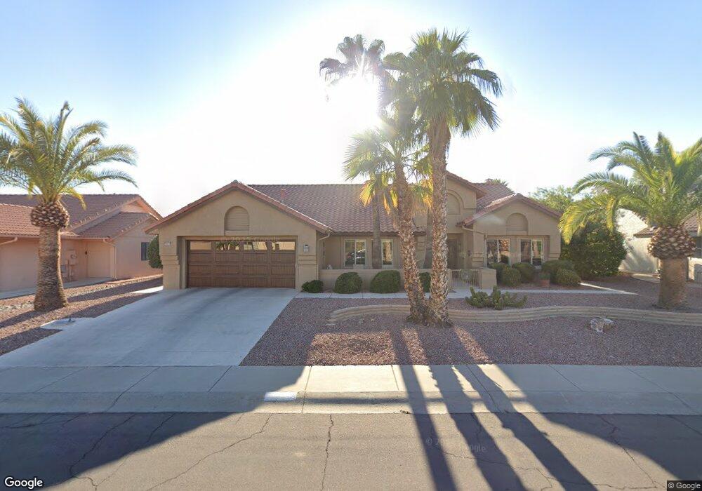
20410 N 142nd Ave Sun City West, AZ 85375
Estimated Value: $430,246 - $652,000
--
Bed
3
Baths
2,150
Sq Ft
$238/Sq Ft
Est. Value
About This Home
This home is located at 20410 N 142nd Ave, Sun City West, AZ 85375 and is currently estimated at $510,812, approximately $237 per square foot. 20410 N 142nd Ave is a home located in Maricopa County with nearby schools including Arizona Charter Academy and FourteenSix Christian Academy.
Ownership History
Date
Name
Owned For
Owner Type
Purchase Details
Closed on
Oct 20, 2022
Sold by
Carolyn B Taylor Revocable Trust
Bought by
Richard And Carolyn Taylor Living Trust
Current Estimated Value
Purchase Details
Closed on
Sep 17, 2009
Sold by
Taylor Richard A and Taylor Carolyn B
Bought by
Taylor Carolyn B and Carolyn B Taylor Revocable Living Trust
Purchase Details
Closed on
Aug 30, 1999
Sold by
Lynn Robert C and Lynn Jean N
Bought by
Davis Evan L and Davis Sarah B
Home Financials for this Owner
Home Financials are based on the most recent Mortgage that was taken out on this home.
Original Mortgage
$80,000
Interest Rate
7.68%
Mortgage Type
FHA
Purchase Details
Closed on
Sep 6, 1995
Sold by
Lynn Robert C and Lynn Jean N
Bought by
Lynn Robert C and Lynn Jean N
Create a Home Valuation Report for This Property
The Home Valuation Report is an in-depth analysis detailing your home's value as well as a comparison with similar homes in the area
Home Values in the Area
Average Home Value in this Area
Purchase History
| Date | Buyer | Sale Price | Title Company |
|---|---|---|---|
| Richard And Carolyn Taylor Living Trust | -- | -- | |
| Taylor Carolyn B | -- | None Available | |
| Davis Evan L | $252,000 | First American Title | |
| Lynn Robert C | -- | -- |
Source: Public Records
Mortgage History
| Date | Status | Borrower | Loan Amount |
|---|---|---|---|
| Previous Owner | Davis Evan L | $80,000 |
Source: Public Records
Tax History Compared to Growth
Tax History
| Year | Tax Paid | Tax Assessment Tax Assessment Total Assessment is a certain percentage of the fair market value that is determined by local assessors to be the total taxable value of land and additions on the property. | Land | Improvement |
|---|---|---|---|---|
| 2025 | $2,536 | $34,925 | -- | -- |
| 2024 | $2,290 | $33,262 | -- | -- |
| 2023 | $2,290 | $38,470 | $7,690 | $30,780 |
| 2022 | $2,144 | $32,120 | $6,420 | $25,700 |
| 2021 | $2,236 | $30,800 | $6,160 | $24,640 |
| 2020 | $2,181 | $29,420 | $5,880 | $23,540 |
| 2019 | $2,136 | $26,520 | $5,300 | $21,220 |
| 2018 | $2,056 | $26,200 | $5,240 | $20,960 |
| 2017 | $1,978 | $25,300 | $5,060 | $20,240 |
| 2016 | $1,894 | $23,970 | $4,790 | $19,180 |
| 2015 | $1,817 | $21,800 | $4,360 | $17,440 |
Source: Public Records
Map
Nearby Homes
- 13910 W Oak Glen Dr
- 14170 W Desert Glen Dr
- 14121 W Casa Linda Dr
- 14222 W Yosemite Dr
- 13819 W Elmbrook Dr
- 14419 W Yosemite Dr
- 14134 W Desert Glen Dr Unit 34
- 20826 N Desert Glen Dr
- 20007 N Alta Loma Dr
- 13814 W Greenview Dr
- 13812 W Pinetree Dr
- 20826 N Gable Hill Dr
- 19611 N Trail Ridge Dr
- 19951 N Greenview Dr
- 14337 W Circle Ridge Dr Unit 41
- 14123 W Yosemite Dr
- 19921 N Greenview Dr
- 13725 W Springdale Dr
- 14123 W Circle Ridge Dr Unit 40
- 14111 W Circle Ridge Dr
- 20406 N 142nd Ave
- 20414 N 142nd Ave
- 20413 N 142nd Ave
- 20409 N 142nd Ave
- 20402 N 142nd Ave
- 20418 N 142nd Ave
- 20403 N 142nd Ave
- 20421 N 142nd Ave
- 20422 N 142nd Ave
- 20406 N 141st Dr
- 14115 W Jaguar Dr
- 20402 N 141st Dr
- 20425 N 142nd Ave
- 14111 W Jaguar Dr Unit 35
- 20426 N 142nd Ave
- 20414 N 141st Dr
- 20429 N 142nd Ave
- 14107 W Jaguar Dr
- 20430 N 142nd Ave
- 20239 N Meadowood Dr