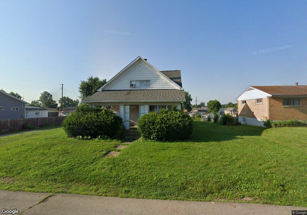
2042 Auburndale Ave Dayton, OH 45414
Northridge NeighborhoodEstimated Value: $116,408 - $156,000
3
Beds
2
Baths
1,589
Sq Ft
$88/Sq Ft
Est. Value
About This Home
This home is located at 2042 Auburndale Ave, Dayton, OH 45414 and is currently estimated at $139,352, approximately $87 per square foot. 2042 Auburndale Ave is a home located in Montgomery County with nearby schools including Northridge High School, Horizon Science Academy-Dayton Elementary School, and Deca Prep.
Ownership History
Date
Name
Owned For
Owner Type
Purchase Details
Closed on
Apr 12, 2018
Sold by
Szekely Coleman S
Bought by
Morcos Tarek
Current Estimated Value
Purchase Details
Closed on
Jun 20, 2017
Sold by
Szekely Rose Mary and Szekely Rose M
Bought by
Szekely Coleman S
Purchase Details
Closed on
Feb 19, 2003
Sold by
Szekely Coleman and Szekely Coleman Steve
Bought by
Szekely Rose Mary
Create a Home Valuation Report for This Property
The Home Valuation Report is an in-depth analysis detailing your home's value as well as a comparison with similar homes in the area
Home Values in the Area
Average Home Value in this Area
Purchase History
| Date | Buyer | Sale Price | Title Company |
|---|---|---|---|
| Morcos Tarek | $10,000 | None Available | |
| Szekely Coleman S | $20,000 | Landmark Tite Agency South I | |
| Szekely Rose Mary | -- | -- |
Source: Public Records
Tax History Compared to Growth
Tax History
| Year | Tax Paid | Tax Assessment Tax Assessment Total Assessment is a certain percentage of the fair market value that is determined by local assessors to be the total taxable value of land and additions on the property. | Land | Improvement |
|---|---|---|---|---|
| 2024 | $1,791 | $21,460 | $5,320 | $16,140 |
| 2023 | $1,791 | $21,460 | $5,320 | $16,140 |
| 2022 | $1,644 | $15,660 | $3,880 | $11,780 |
| 2021 | $1,649 | $15,660 | $3,880 | $11,780 |
| 2020 | $964 | $9,280 | $3,880 | $5,400 |
| 2019 | $659 | $5,700 | $4,300 | $1,400 |
| 2018 | $849 | $6,830 | $4,300 | $2,530 |
| 2017 | $113 | $6,830 | $4,300 | $2,530 |
| 2016 | $759 | $15,100 | $4,300 | $10,800 |
| 2015 | $654 | $15,100 | $4,300 | $10,800 |
| 2014 | $654 | $15,100 | $4,300 | $10,800 |
| 2012 | -- | $19,670 | $5,220 | $14,450 |
Source: Public Records
Map
Nearby Homes
- 2059 Neff Rd
- 2124 Lodell Ave
- 2417 Neff Rd
- 3865 Hillmont Ave
- 2320 Ottello Ave
- 2233 Ottello Ave
- 1640 Pinecrest Dr
- 4400 Canyon Rd
- 3394 Lodge Ave Unit 3384
- 2585 Coronette Ave
- 2424 Ottello Ave
- 4404 Ross Ave
- 2171 Argray Dr
- 2412 Neva Dr
- 32 Stafford Ave
- 2422 Oneida Ave
- 3815 Old Riverside Dr
- 1904 Edgeworth Ave
- 644 Redwood Ave
- 2039 Ontario Ave
- 2040 Auburndale Ave
- 2038 Auburndale Ave
- 2037 Hillsdale Ave
- 2066 Auburndale Ave
- 3973 Westmont Place
- 2055 Hillsdale Ave
- 2039 Auburndale Ave
- 3959 Westmont Place
- 2035 Auburndale Ave
- 2045 Auburndale Ave
- 2144 Keenan Ave
- 2061 Auburndale Ave
- 2029 Auburndale Ave
- 2065 Hillsdale Ave
- 2017 Hillsdale Ave
- 2126 Keenan Ave
- 2073 Auburndale Ave
- 2154 Keenan Ave
- 2116 Keenan Ave
- 2025 Auburndale Ave