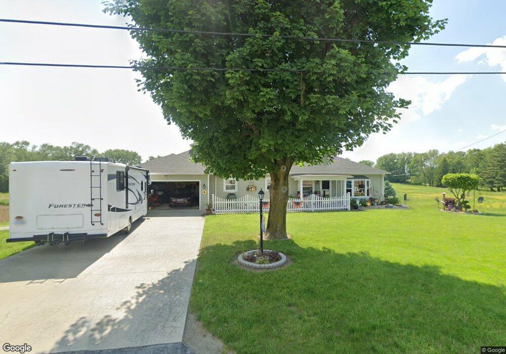
2042 Port Clinton Rd Fremont, OH 43420
Estimated Value: $187,000 - $202,891
3
Beds
1
Bath
1,548
Sq Ft
$126/Sq Ft
Est. Value
About This Home
This home is located at 2042 Port Clinton Rd, Fremont, OH 43420 and is currently estimated at $195,723, approximately $126 per square foot. 2042 Port Clinton Rd is a home located in Sandusky County with nearby schools including Fremont Ross High School, St. Ann Catholic School, and St. Joseph School.
Ownership History
Date
Name
Owned For
Owner Type
Purchase Details
Closed on
Jun 30, 2011
Sold by
Wojdyla Philip J and Wojdyla Kristine
Bought by
Wojdyla Michael P and Wojdyla Kimberly S
Current Estimated Value
Purchase Details
Closed on
Dec 11, 2003
Sold by
Wojdyla Ruth I
Bought by
Wojdyla Nancy K and Wojdyla Philip J
Purchase Details
Closed on
Feb 1, 1990
Bought by
Wojdyla Michael P and Wojdyla Kimberly S
Create a Home Valuation Report for This Property
The Home Valuation Report is an in-depth analysis detailing your home's value as well as a comparison with similar homes in the area
Home Values in the Area
Average Home Value in this Area
Purchase History
| Date | Buyer | Sale Price | Title Company |
|---|---|---|---|
| Wojdyla Michael P | $55,000 | Attorney | |
| Wojdyla Nancy K | $78,750 | -- | |
| Wojdyla Michael P | -- | -- |
Source: Public Records
Tax History Compared to Growth
Tax History
| Year | Tax Paid | Tax Assessment Tax Assessment Total Assessment is a certain percentage of the fair market value that is determined by local assessors to be the total taxable value of land and additions on the property. | Land | Improvement |
|---|---|---|---|---|
| 2024 | $2,061 | $64,480 | $15,020 | $49,460 |
| 2023 | $2,061 | $51,560 | $12,010 | $39,550 |
| 2022 | $1,716 | $51,560 | $12,010 | $39,550 |
| 2021 | $2,393 | $51,560 | $12,010 | $39,550 |
| 2020 | $2,064 | $42,850 | $12,010 | $30,840 |
| 2019 | $2,074 | $42,850 | $12,010 | $30,840 |
| 2018 | $2,076 | $42,850 | $12,010 | $30,840 |
| 2017 | $1,965 | $40,050 | $12,010 | $28,040 |
| 2016 | $1,764 | $40,050 | $12,010 | $28,040 |
| 2015 | $1,740 | $40,050 | $12,010 | $28,040 |
| 2014 | $1,620 | $35,010 | $8,720 | $26,290 |
| 2013 | $1,591 | $35,010 | $8,720 | $26,290 |
Source: Public Records
Map
Nearby Homes
- 1730 Port Clinton Rd Unit 41
- 1730 Port Clinton Rd
- 1730 Port Clinton Rd Unit 33
- 0 Sean Dr
- Outlot A Sean Dr
- 711 Bloom Rd
- 2100 Ohio 53
- 900 Spring St
- 1441 White Ave
- 612 2nd St
- 533 Sandusky Ave Unit 535
- 711 Rawson Ave
- 1227 White Ave
- 2219 Oak Harbor Rd
- 433 Sandusky Ave
- 1548 North St
- 340 340 Sandusky Ave
- 516 N Front St
- 1707 North St
- 1720 North St
- 432 Kingsgate Dr
- 416 Kingsgate Dr
- 442 Kingsgate Dr
- 450 Kingsgate Dr
- 427 Kingsgate Dr
- 2124 Port Clinton Rd
- 437 Kingsgate Dr
- 2132 Port Clinton Rd
- 2017 Port Clinton Rd
- 1944 Port Clinton Rd
- 2136 Port Clinton Rd
- 460 Kingsgate Dr
- 451 Kingsgate Dr
- 1961 Melody Dr
- 1960 Melody Dr
- 1939 Port Clinton Rd
- 1927 Valley View Terrace
- 2144 Port Clinton Rd
- 1930 Port Clinton Rd
- 1930 Valley View Terrace