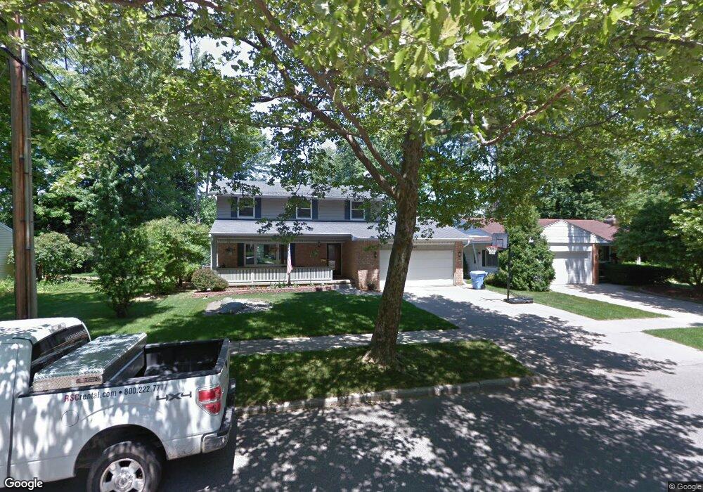
2042 Rock Way Lansing, MI 48910
Colonial Village NeighborhoodEstimated Value: $236,871 - $250,000
--
Bed
2
Baths
1,778
Sq Ft
$137/Sq Ft
Est. Value
About This Home
This home is located at 2042 Rock Way, Lansing, MI 48910 and is currently estimated at $243,718, approximately $137 per square foot. 2042 Rock Way is a home located in Ingham County with nearby schools including Averill Elementary School, Attwood School, and J.W. Sexton High School.
Ownership History
Date
Name
Owned For
Owner Type
Purchase Details
Closed on
Feb 20, 2025
Sold by
Luzbetak Matthew D and Luzbetak Amy B
Bought by
Matthew D Luzbetak And Amy B Luzbetak Living and Luzbetak
Current Estimated Value
Purchase Details
Closed on
Sep 22, 2016
Sold by
Reaves Patrick and Reaves Amanda
Bought by
Goulding Linda S
Purchase Details
Closed on
May 12, 2000
Sold by
Stewart Stephen K and Stewart Trudy J
Bought by
Luzbetak Matthew D and Luzbetak Amy B
Home Financials for this Owner
Home Financials are based on the most recent Mortgage that was taken out on this home.
Original Mortgage
$123,418
Interest Rate
8.21%
Mortgage Type
FHA
Purchase Details
Closed on
Jun 23, 1987
Sold by
Schutte Mary L
Bought by
Stewart Stephen K and Stewart Trudy J
Create a Home Valuation Report for This Property
The Home Valuation Report is an in-depth analysis detailing your home's value as well as a comparison with similar homes in the area
Home Values in the Area
Average Home Value in this Area
Purchase History
| Date | Buyer | Sale Price | Title Company |
|---|---|---|---|
| Matthew D Luzbetak And Amy B Luzbetak Living | -- | None Listed On Document | |
| Goulding Linda S | -- | None Available | |
| Luzbetak Matthew D | $124,900 | -- | |
| Stewart Stephen K | $87,500 | -- |
Source: Public Records
Mortgage History
| Date | Status | Borrower | Loan Amount |
|---|---|---|---|
| Previous Owner | Luzbetak Matthew D | $123,418 |
Source: Public Records
Tax History Compared to Growth
Tax History
| Year | Tax Paid | Tax Assessment Tax Assessment Total Assessment is a certain percentage of the fair market value that is determined by local assessors to be the total taxable value of land and additions on the property. | Land | Improvement |
|---|---|---|---|---|
| 2025 | $4,061 | $115,300 | $11,400 | $103,900 |
| 2024 | $33 | $97,800 | $11,400 | $86,400 |
| 2023 | $3,806 | $85,300 | $11,400 | $73,900 |
| 2022 | $3,428 | $81,100 | $9,900 | $71,200 |
| 2021 | $3,357 | $76,200 | $9,400 | $66,800 |
| 2020 | $3,337 | $74,500 | $9,400 | $65,100 |
| 2019 | $3,200 | $66,900 | $9,400 | $57,500 |
| 2018 | $2,997 | $62,300 | $9,400 | $52,900 |
| 2017 | $2,870 | $62,300 | $9,400 | $52,900 |
| 2016 | $2,765 | $53,900 | $9,400 | $44,500 |
| 2015 | $2,765 | $50,000 | $18,802 | $31,198 |
| 2014 | $2,765 | $49,600 | $12,130 | $37,470 |
Source: Public Records
Map
Nearby Homes
- 2039 Holly Way
- 3125 Boston Blvd
- 2812 Pleasant Grove Rd
- 2920 Pleasant Grove Rd Unit 1
- 2409 Victor Ave
- 1607 Holly Way
- 1618 Loraine Ave
- 3312 Pleasant Grove Rd
- 2505 Hanover Dr
- 3330 Avalon St
- 1404 Kelsey Ave
- 3336 Avalon St
- 2905 S Catherine St
- 3324 Viking St
- 3212 Ingham St
- 2710 Bedford Rd
- 2200 Rossiter Place
- 1420 Poxson Ave
- 2201 Pamela Place
- 3334 Ingham St