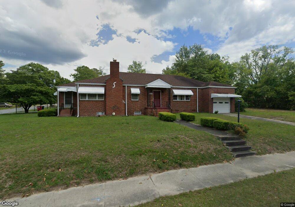
2044 Pio Nono Ave Macon, GA 31206
Estimated Value: $78,000 - $174,000
3
Beds
2
Baths
2,074
Sq Ft
$58/Sq Ft
Est. Value
About This Home
This home is located at 2044 Pio Nono Ave, Macon, GA 31206 and is currently estimated at $120,011, approximately $57 per square foot. 2044 Pio Nono Ave is a home located in Bibb County with nearby schools including Hartley Elementary School, Southwest High School, and Cirrus Charter Academy.
Ownership History
Date
Name
Owned For
Owner Type
Purchase Details
Closed on
May 7, 2025
Sold by
Dinkins Joseph and Dinkins Connie
Bought by
Scott Trenton
Current Estimated Value
Purchase Details
Closed on
Aug 31, 2011
Sold by
Dinkins Joseph
Bought by
Dinkins Joseph and Dinkins Connie
Home Financials for this Owner
Home Financials are based on the most recent Mortgage that was taken out on this home.
Original Mortgage
$38,000
Interest Rate
4.55%
Mortgage Type
New Conventional
Create a Home Valuation Report for This Property
The Home Valuation Report is an in-depth analysis detailing your home's value as well as a comparison with similar homes in the area
Home Values in the Area
Average Home Value in this Area
Purchase History
| Date | Buyer | Sale Price | Title Company |
|---|---|---|---|
| Scott Trenton | $63,750 | None Listed On Document | |
| Scott Trenton | $63,750 | None Listed On Document | |
| Dinkins Joseph | -- | None Available |
Source: Public Records
Mortgage History
| Date | Status | Borrower | Loan Amount |
|---|---|---|---|
| Previous Owner | Dinkins Joseph | $38,000 |
Source: Public Records
Tax History Compared to Growth
Tax History
| Year | Tax Paid | Tax Assessment Tax Assessment Total Assessment is a certain percentage of the fair market value that is determined by local assessors to be the total taxable value of land and additions on the property. | Land | Improvement |
|---|---|---|---|---|
| 2025 | $1,026 | $41,740 | $2,200 | $39,540 |
| 2024 | $1,060 | $41,740 | $2,200 | $39,540 |
| 2023 | $1,060 | $41,740 | $2,200 | $39,540 |
| 2022 | $1,218 | $35,178 | $3,606 | $31,572 |
| 2021 | $1,337 | $35,178 | $3,606 | $31,572 |
| 2020 | $1,363 | $35,106 | $3,606 | $31,500 |
| 2019 | $1,374 | $35,106 | $3,606 | $31,500 |
| 2018 | $2,285 | $35,106 | $3,606 | $31,500 |
| 2017 | $1,315 | $35,106 | $3,606 | $31,500 |
| 2016 | $1,291 | $37,320 | $3,606 | $33,714 |
| 2015 | $1,828 | $37,320 | $3,606 | $33,714 |
| 2014 | $2,102 | $37,320 | $3,606 | $33,714 |
Source: Public Records
Map
Nearby Homes
- 2032 Vining Cir
- 2125 Cedar Ave
- 1191 Carroll St
- 1049 Anthony Rd
- 1045 Anthony Rd
- 210 Moseley Ave
- 1121 Carroll St
- 1144 Carroll St
- 2349 Mason St
- 710 Poppy Ave
- 466 Petunia Ave
- 1545 Anthony Rd
- 2249 Lowe St
- 576 Pansy Ave
- 2420 Adams Ave
- 1580 Marigold Ave
- 2350 Anthony Terrace
- 1568 Marigold Ave
- 430 Daffodil St
- 777 Grosso Ave
- 2086 Pio Nono Ave
- 2036 Vining Cir
- 2010 Pio Nono Ave
- 2041 Vining Cir
- 2037 Vining Cir
- 2028 Vining Cir
- 2093 Mason St
- 2033 Vining Cir
- 2000 Pio Nono Ave
- 2029 Vining Cir
- 128 Moseley Ave
- 2024 Vining Cir
- 2080 Mason St
- 1963 Vining Cir
- 1967 Vining Cir
- 1959 Vining Cir
- 2092 Mason St
- 2021 Vining Cir
- 136 Moseley Ave
- 2055 Adams Ave