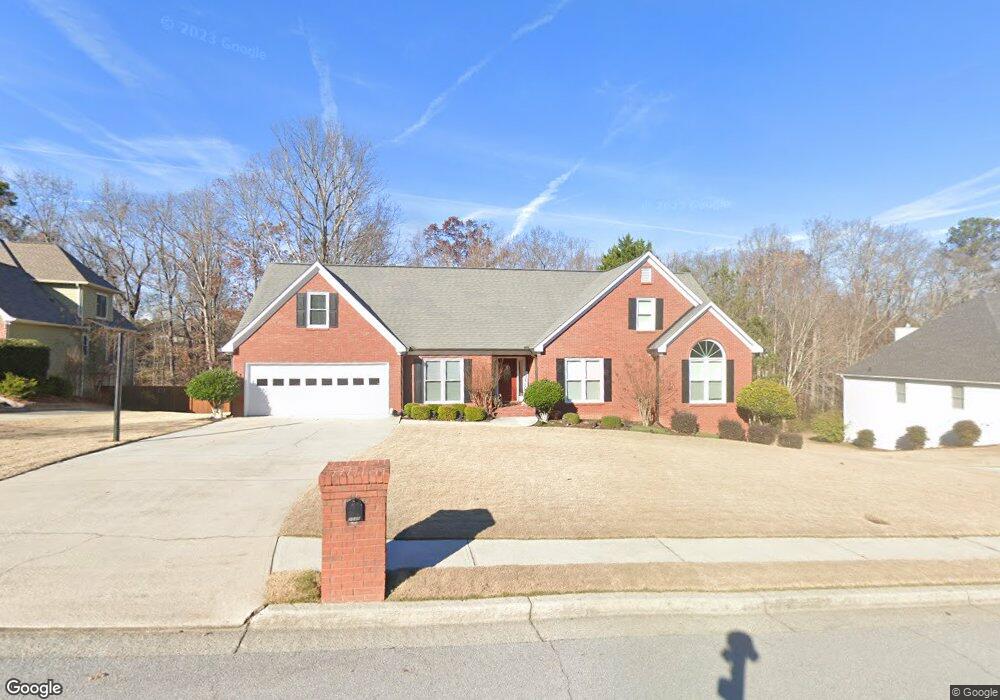
2045 Ashton Pointe Dr Unit 1 Dacula, GA 30019
Estimated Value: $396,774 - $423,000
3
Beds
2
Baths
2,352
Sq Ft
$175/Sq Ft
Est. Value
About This Home
This home is located at 2045 Ashton Pointe Dr Unit 1, Dacula, GA 30019 and is currently estimated at $410,944, approximately $174 per square foot. 2045 Ashton Pointe Dr Unit 1 is a home located in Gwinnett County with nearby schools including Fort Daniel Elementary School, Frank N. Osborne Middle School, and Mill Creek High School.
Ownership History
Date
Name
Owned For
Owner Type
Purchase Details
Closed on
Oct 26, 2000
Sold by
Hicks James L and Hicks Cynthia K
Bought by
Simpson Kenneth T and Simpson Julia A
Current Estimated Value
Home Financials for this Owner
Home Financials are based on the most recent Mortgage that was taken out on this home.
Original Mortgage
$184,500
Outstanding Balance
$65,956
Interest Rate
7.83%
Mortgage Type
New Conventional
Estimated Equity
$344,988
Purchase Details
Closed on
Aug 17, 1995
Sold by
Kas Const Inc
Bought by
Hicks James L Cynthia K
Create a Home Valuation Report for This Property
The Home Valuation Report is an in-depth analysis detailing your home's value as well as a comparison with similar homes in the area
Home Values in the Area
Average Home Value in this Area
Purchase History
| Date | Buyer | Sale Price | Title Company |
|---|---|---|---|
| Simpson Kenneth T | $205,000 | -- | |
| Hicks James L Cynthia K | $157,900 | -- |
Source: Public Records
Mortgage History
| Date | Status | Borrower | Loan Amount |
|---|---|---|---|
| Open | Simpson Kenneth T | $184,500 | |
| Closed | Hicks James L Cynthia K | $0 |
Source: Public Records
Tax History Compared to Growth
Tax History
| Year | Tax Paid | Tax Assessment Tax Assessment Total Assessment is a certain percentage of the fair market value that is determined by local assessors to be the total taxable value of land and additions on the property. | Land | Improvement |
|---|---|---|---|---|
| 2025 | $3,571 | $223,360 | $44,000 | $179,360 |
| 2024 | $3,710 | $121,280 | $22,400 | $98,880 |
| 2023 | $3,710 | $121,280 | $22,400 | $98,880 |
| 2022 | $3,672 | $121,280 | $22,400 | $98,880 |
| 2021 | $3,558 | $113,160 | $22,400 | $90,760 |
| 2020 | $3,209 | $95,840 | $22,400 | $73,440 |
| 2019 | $3,125 | $95,840 | $22,400 | $73,440 |
| 2018 | $3,128 | $95,840 | $22,400 | $73,440 |
| 2016 | $2,641 | $72,440 | $14,400 | $58,040 |
| 2015 | $2,664 | $72,440 | $14,400 | $58,040 |
| 2014 | $2,676 | $72,440 | $14,400 | $58,040 |
Source: Public Records
Map
Nearby Homes
- 2970 Waverly Place Dr
- 2985 Ashton Pointe Cir
- 2070 Trinity Mill Dr
- 2405 Millwater Crossing
- 2455 Millwater Crossing
- 0 Hog Mountain Church Road and Auburn Rd
- 2955 Windsong Park Ln Unit 1
- 2996 Cambridge Hill Dr
- 3119 Tadmore Ct
- 2585 Millwater Crossing
- 3225 Mary Todd Ln
- 2107 Town Manor Ct
- 2585 Braselton Hwy
- 3053 Cambridge Hill Dr
- 2128 Town Manor Ct
- 2220 Cambridge Hill Ct
- 3177 Hog Mountain Rd
- 2230 Cambridge Hill Ct
- 2035 Ashton Pointe Dr Unit 1
- 2055 Ashton Pointe Dr Unit 17
- 2055 Ashton Pointe Dr
- 2065 Ashton Pointe Dr
- 2025 Ashton Pointe Dr
- 2040 Ashton Pointe Dr
- 2030 Ashton Pointe Dr
- 2100 Cain Commons Dr
- 2060 Ashton Pointe Dr
- 2110 Cain Commons Dr
- 2050 Ashton Pointe Dr Unit 1
- 2015 Ashton Pointe Dr Unit 1
- 2020 Ashton Pointe Dr
- 3007 Sarah Ellen Ct
- 3017 Sarah Ellen Ct
- 3000 Waverly Place Dr
- 2970 Ashton Pointe Cir Unit 1
- 2101 Cain Commons Dr
- 2980 Ashton Pointe Cir Unit 1
- 2980 Ashton Point