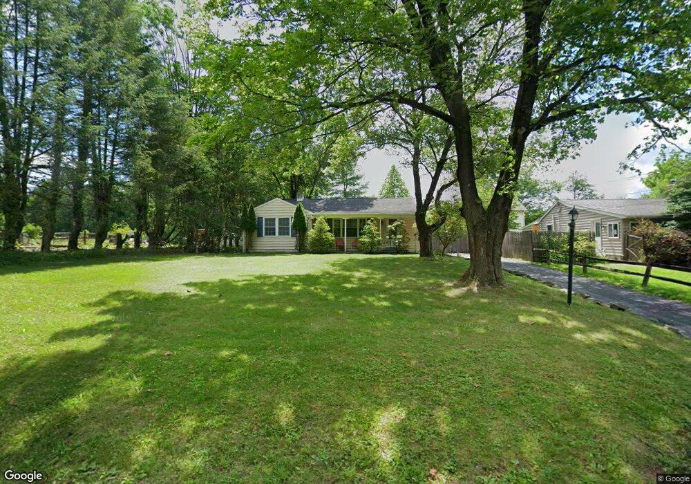
2045 Turk Rd Doylestown, PA 18901
Estimated Value: $376,000 - $514,000
2
Beds
2
Baths
1,046
Sq Ft
$410/Sq Ft
Est. Value
About This Home
This home is located at 2045 Turk Rd, Doylestown, PA 18901 and is currently estimated at $428,921, approximately $410 per square foot. 2045 Turk Rd is a home located in Bucks County with nearby schools including Kutz Elementary School, Lenape Middle School, and Central Bucks High School-West.
Ownership History
Date
Name
Owned For
Owner Type
Purchase Details
Closed on
Sep 16, 2024
Sold by
Mckay Michael C and Mckay Aubrey N
Bought by
Mckay Aubrey N
Current Estimated Value
Purchase Details
Closed on
Jun 28, 2010
Sold by
Calhoun Michael
Bought by
Mckay Aubrey N and Mckay Michael C
Home Financials for this Owner
Home Financials are based on the most recent Mortgage that was taken out on this home.
Original Mortgage
$214,116
Interest Rate
4.75%
Mortgage Type
FHA
Purchase Details
Closed on
Jun 15, 2006
Sold by
Ehlinger Philip C and Ehlinger Michele
Bought by
Calhoun Michael
Purchase Details
Closed on
Jan 6, 2006
Sold by
Horn Vernon and Horn Edith
Bought by
Ehlinger Philip C and Ehlinger Michele
Home Financials for this Owner
Home Financials are based on the most recent Mortgage that was taken out on this home.
Original Mortgage
$166,375
Interest Rate
6.28%
Mortgage Type
Seller Take Back
Create a Home Valuation Report for This Property
The Home Valuation Report is an in-depth analysis detailing your home's value as well as a comparison with similar homes in the area
Home Values in the Area
Average Home Value in this Area
Purchase History
| Date | Buyer | Sale Price | Title Company |
|---|---|---|---|
| Mckay Aubrey N | -- | None Listed On Document | |
| Mckay Aubrey N | $217,000 | None Available | |
| Calhoun Michael | $210,000 | None Available | |
| Ehlinger Philip C | $150,000 | None Available |
Source: Public Records
Mortgage History
| Date | Status | Borrower | Loan Amount |
|---|---|---|---|
| Previous Owner | Mckay Aubrey N | $214,116 | |
| Previous Owner | Ehlinger Philip C | $166,375 |
Source: Public Records
Tax History Compared to Growth
Tax History
| Year | Tax Paid | Tax Assessment Tax Assessment Total Assessment is a certain percentage of the fair market value that is determined by local assessors to be the total taxable value of land and additions on the property. | Land | Improvement |
|---|---|---|---|---|
| 2025 | $2,478 | $14,000 | $4,520 | $9,480 |
| 2024 | $2,478 | $14,000 | $4,520 | $9,480 |
| 2023 | $2,362 | $14,000 | $4,520 | $9,480 |
| 2022 | $2,336 | $14,000 | $4,520 | $9,480 |
| 2021 | $2,288 | $14,000 | $4,520 | $9,480 |
| 2020 | $2,277 | $14,000 | $4,520 | $9,480 |
| 2019 | $2,253 | $14,000 | $4,520 | $9,480 |
| 2018 | $2,246 | $14,000 | $4,520 | $9,480 |
| 2017 | $2,228 | $14,000 | $4,520 | $9,480 |
| 2016 | $2,214 | $14,000 | $4,520 | $9,480 |
| 2015 | -- | $14,000 | $4,520 | $9,480 |
| 2014 | -- | $14,000 | $4,520 | $9,480 |
Source: Public Records
Map
Nearby Homes
- 82 Avalon Ct Unit 2005
- 17 Addison Ct Unit 2703
- 9 Cornerstone Ct Unit 4105
- 137 Pebble Woods Dri Pebble Woods Dr
- 60 Quarry Rd
- 1 Squirrel Rd
- 125 Edison Furlong Rd
- 78 Tower Hill Rd
- 2320 Turk Rd
- 45 Bedford Ave
- 272 Fox Chase Ln
- 3 Steeplechase Dr
- 403 S Main St Unit S201
- 21 Shady Springs Dr
- 420 Edison Furlong Rd
- 89 Homestead Dr
- 195 Lafayette St
- 9 Mill Creek Dr
- 236 Green St
- 223 Cherry Ln