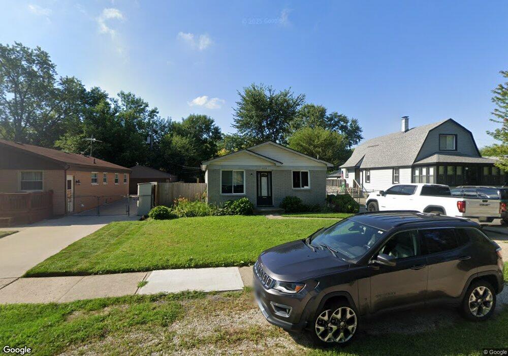
20450 Webster St Clinton Township, MI 48035
Estimated Value: $201,452 - $211,000
3
Beds
1
Bath
960
Sq Ft
$215/Sq Ft
Est. Value
About This Home
This home is located at 20450 Webster St, Clinton Township, MI 48035 and is currently estimated at $206,863, approximately $215 per square foot. 20450 Webster St is a home located in Macomb County with nearby schools including Clintondale High School and St. Thecla Catholic School.
Ownership History
Date
Name
Owned For
Owner Type
Purchase Details
Closed on
Jul 2, 2007
Sold by
Paragon Relocation Resources Inc
Bought by
Savoie Aaron M
Current Estimated Value
Purchase Details
Closed on
Feb 11, 2006
Sold by
Anderson Kevin
Bought by
Paragon Relocation Resources Inc
Purchase Details
Closed on
Jun 21, 2001
Sold by
Brian Patrick M
Bought by
Anderson Kevin
Home Financials for this Owner
Home Financials are based on the most recent Mortgage that was taken out on this home.
Original Mortgage
$117,750
Interest Rate
7.27%
Create a Home Valuation Report for This Property
The Home Valuation Report is an in-depth analysis detailing your home's value as well as a comparison with similar homes in the area
Home Values in the Area
Average Home Value in this Area
Purchase History
| Date | Buyer | Sale Price | Title Company |
|---|---|---|---|
| Savoie Aaron M | $119,500 | None Available | |
| Paragon Relocation Resources Inc | $119,500 | None Available | |
| Anderson Kevin | $125,000 | -- |
Source: Public Records
Mortgage History
| Date | Status | Borrower | Loan Amount |
|---|---|---|---|
| Previous Owner | Anderson Kevin | $117,750 |
Source: Public Records
Tax History Compared to Growth
Tax History
| Year | Tax Paid | Tax Assessment Tax Assessment Total Assessment is a certain percentage of the fair market value that is determined by local assessors to be the total taxable value of land and additions on the property. | Land | Improvement |
|---|---|---|---|---|
| 2025 | $2,454 | $91,600 | $0 | $0 |
| 2024 | $1,710 | $85,300 | $0 | $0 |
| 2023 | $1,630 | $75,800 | $0 | $0 |
| 2022 | $2,383 | $67,700 | $0 | $0 |
| 2021 | $2,273 | $63,200 | $0 | $0 |
| 2020 | $1,524 | $58,700 | $0 | $0 |
| 2019 | $1,826 | $49,400 | $0 | $0 |
| 2018 | $1,701 | $43,100 | $0 | $0 |
| 2017 | $1,671 | $36,300 | $6,600 | $29,700 |
| 2016 | $1,626 | $36,300 | $0 | $0 |
| 2015 | -- | $32,900 | $0 | $0 |
| 2014 | -- | $33,600 | $0 | $0 |
| 2011 | -- | $47,500 | $11,300 | $36,200 |
Source: Public Records
Map
Nearby Homes
- 20446 Williamson St
- 20415 Nicke St
- 20440 Nicke St
- 20158 Williamson St
- 20219 Finley St
- 20810 Colman St
- 20851 Elm Forest Ct
- 34029 Little MacK Ave
- 20118 Nicke St
- 19630 Webster St
- 20178 Lakeworth St
- 19565 Stafford St
- 19573 Heckman St
- 19633 E 14 Mile Rd
- 19578 Opal St
- 19541 Colman St
- 19560 Spagnuolo Ln Unit 22
- 19732 Voiland St
- 34161 Beaconsfield St
- 19793 Electra St
- 20456 Webster St
- 20442 Webster St
- 20426 Webster St
- 20451 Broadacres St
- 20470 Webster St
- 20437 Broadacres St
- 20459 Broadacres St
- 20416 Webster St
- 20427 Broadacres St
- 20451 Webster St
- 20471 Broadacres St
- 20459 Webster St
- 20441 Webster St
- 20425 Broadacres St
- 20433 Webster St
- 20496 Webster St
- 20408 Webster St
- 00 Webster
- 20479 Webster St
- 20423 Broadacres St