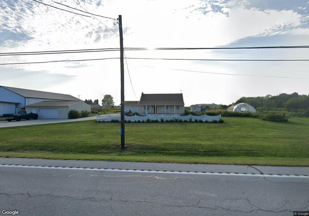
2046 N State Route 53 Tiffin, OH 44883
Estimated Value: $194,000 - $281,834
3
Beds
2
Baths
1,568
Sq Ft
$150/Sq Ft
Est. Value
About This Home
This home is located at 2046 N State Route 53, Tiffin, OH 44883 and is currently estimated at $235,209, approximately $150 per square foot. 2046 N State Route 53 is a home with nearby schools including Columbian High School, Calvert Catholic Elementary School, and Calvert High School.
Ownership History
Date
Name
Owned For
Owner Type
Purchase Details
Closed on
Dec 11, 2020
Sold by
Dandurand Kathleen S
Bought by
Dandurand Steven R and Decker Ashlee E
Current Estimated Value
Purchase Details
Closed on
Jun 18, 2015
Sold by
Weller Audrey R
Bought by
Dandurand Kathleen S
Purchase Details
Closed on
Dec 16, 2010
Sold by
Weller Audrey R and Donald & Audrey Weller Living
Bought by
Weller Audrey R and Weller Donald
Purchase Details
Closed on
Feb 20, 1996
Sold by
Weller Audrey R
Bought by
Weller Donald R
Purchase Details
Closed on
Feb 4, 1993
Sold by
Michaels Doris E
Bought by
Weller Audrey R
Create a Home Valuation Report for This Property
The Home Valuation Report is an in-depth analysis detailing your home's value as well as a comparison with similar homes in the area
Home Values in the Area
Average Home Value in this Area
Purchase History
| Date | Buyer | Sale Price | Title Company |
|---|---|---|---|
| Dandurand Steven R | -- | None Available | |
| Dandurand Kathleen S | $80,000 | Assured Title | |
| Weller Audrey R | -- | None Available | |
| Weller Donald R | -- | -- | |
| Weller Audrey R | $37,500 | -- |
Source: Public Records
Tax History Compared to Growth
Tax History
| Year | Tax Paid | Tax Assessment Tax Assessment Total Assessment is a certain percentage of the fair market value that is determined by local assessors to be the total taxable value of land and additions on the property. | Land | Improvement |
|---|---|---|---|---|
| 2024 | $2,505 | $73,340 | $16,440 | $56,900 |
| 2023 | $2,507 | $73,340 | $16,440 | $56,900 |
| 2022 | $1,650 | $39,830 | $14,430 | $25,400 |
| 2021 | $1,662 | $39,830 | $14,430 | $25,400 |
| 2020 | $1,694 | $39,827 | $14,427 | $25,400 |
| 2019 | $1,656 | $37,668 | $13,703 | $23,965 |
| 2018 | $1,539 | $34,934 | $13,703 | $21,231 |
| 2017 | $1,394 | $34,934 | $13,703 | $21,231 |
| 2016 | $1,245 | $28,613 | $5,467 | $23,146 |
| 2015 | $1,293 | $28,613 | $5,467 | $23,146 |
| 2014 | $1,162 | $28,613 | $5,467 | $23,146 |
| 2013 | $1,224 | $28,613 | $5,467 | $23,146 |
Source: Public Records
Map
Nearby Homes
- 734 E Township Rd Unit 122
- 930 E Township Road 122
- 657 N Sandusky St
- 520 S Tr 1179 A
- 3384 N State Route 53
- 20 Towne and Country Dr
- 65 Northview Dr
- 222 8th Ave
- 508 N Washington St
- 71 Huss St
- 0 Thomas St
- 216 Tomb St
- 225 4th Ave
- 105 Douglas St
- 239 4th Ave
- 226 3rd Ave
- 91 Elwood St
- 263 3rd Ave
- 228 Ohio Ave
- 60 N State Route 101
- 2046 N St Rt 53
- 11 E Township Road 132
- 4 E Township Road 132
- 4 E Tr 132
- 2114 N State Route 53
- 359 W Tr 132
- 1956 N State Route 53
- 17 E Township Road 132
- 1959 N State Route 53
- 2137 N State Route 53
- 1934 N State Route 53
- 16 E Township Road 132
- 1918 N State Route 53
- 130 W Tr 132
- 2171 N State Route 53
- 2171 Ohio 53
- 2171 N St Rt 53
- 1902 N State Route 53
- 1927 Ohio 53
- 13 E Township Road 1153