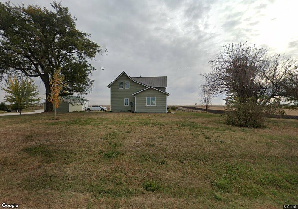
2046 Xavier Ave Duncombe, IA 50532
Estimated Value: $196,000 - $261,000
4
Beds
1
Bath
1,562
Sq Ft
$141/Sq Ft
Est. Value
About This Home
This home is located at 2046 Xavier Ave, Duncombe, IA 50532 and is currently estimated at $220,203, approximately $140 per square foot. 2046 Xavier Ave is a home located in Webster County with nearby schools including Cooper Elementary School, Fort Dodge Middle School, and Fort Dodge Senior High School.
Ownership History
Date
Name
Owned For
Owner Type
Purchase Details
Closed on
Jun 19, 2023
Sold by
Fortune Donald B and Fortune Linda L
Bought by
Fortune Donald B and Fortune Linda L
Current Estimated Value
Purchase Details
Closed on
Jun 15, 2023
Sold by
Steburg Ryann Renae
Bought by
Pohlman Caleb
Create a Home Valuation Report for This Property
The Home Valuation Report is an in-depth analysis detailing your home's value as well as a comparison with similar homes in the area
Purchase History
| Date | Buyer | Sale Price | Title Company |
|---|---|---|---|
| Fortune Donald B | -- | None Listed On Document | |
| Pohlman Caleb | $102,000 | None Listed On Document |
Source: Public Records
Tax History
| Year | Tax Paid | Tax Assessment Tax Assessment Total Assessment is a certain percentage of the fair market value that is determined by local assessors to be the total taxable value of land and additions on the property. | Land | Improvement |
|---|---|---|---|---|
| 2025 | $2,024 | $180,140 | $34,800 | $145,340 |
| 2024 | $2,024 | $171,360 | $26,600 | $144,760 |
| 2023 | $2,112 | $171,360 | $26,600 | $144,760 |
| 2022 | $1,460 | $144,340 | $26,600 | $117,740 |
| 2021 | $1,466 | $104,970 | $26,600 | $78,370 |
| 2020 | $1,466 | $101,600 | $26,600 | $75,000 |
| 2019 | $1,324 | $100,050 | $29,260 | $70,790 |
| 2018 | $1,323 | $90,950 | $26,600 | $64,350 |
| 2017 | $1,308 | $91,900 | $0 | $0 |
| 2016 | $1,332 | $91,900 | $0 | $0 |
| 2015 | $1,332 | $92,540 | $0 | $0 |
| 2014 | $1,276 | $92,540 | $0 | $0 |
Source: Public Records
Map
Nearby Homes
- 415 Wagner St
- 0 Folger and Prince Unit 29723
- 1281 170th St
- 107 S 1st
- 0 Union Ave
- 00 Quail Ave
- 2327 Quail Ave
- TBD- Lot 5 S 42nd St
- Parcel 0727226003
- NA Maple Dr
- 2703 Racine Ave
- 923 N 36th
- 3578 9th Ave N
- 1544 Division St
- 3558 9th Ave N
- 2823 280th St
- 1508 Collins St
- 1410 Locust St
- Lot 3 S 32nd St
- Lot 2 S 32nd St
Your Personal Tour Guide
Ask me questions while you tour the home.