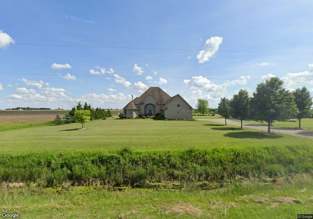
20465 Maplewood Rd Weston, OH 43569
Estimated Value: $261,000 - $478,892
3
Beds
3
Baths
2,435
Sq Ft
$161/Sq Ft
Est. Value
About This Home
This home is located at 20465 Maplewood Rd, Weston, OH 43569 and is currently estimated at $391,973, approximately $160 per square foot. 20465 Maplewood Rd is a home located in Wood County with nearby schools including Bowling Green High School.
Ownership History
Date
Name
Owned For
Owner Type
Purchase Details
Closed on
Jun 29, 2007
Sold by
Smith Michael R and Smith Heather J
Bought by
Smith Michael R and Smith Heather J
Current Estimated Value
Purchase Details
Closed on
Mar 6, 2006
Sold by
Smith David S and Smith Jean G
Bought by
Smith Michael R
Create a Home Valuation Report for This Property
The Home Valuation Report is an in-depth analysis detailing your home's value as well as a comparison with similar homes in the area
Purchase History
| Date | Buyer | Sale Price | Title Company |
|---|---|---|---|
| Smith Michael R | -- | Attorney | |
| Smith Michael R | -- | None Available |
Source: Public Records
Tax History
| Year | Tax Paid | Tax Assessment Tax Assessment Total Assessment is a certain percentage of the fair market value that is determined by local assessors to be the total taxable value of land and additions on the property. | Land | Improvement |
|---|---|---|---|---|
| 2025 | $5,899 | $141,120 | $15,715 | $125,405 |
| 2024 | $5,873 | $141,120 | $15,715 | $125,405 |
| 2023 | $5,873 | $141,130 | $15,720 | $125,410 |
| 2021 | $4,957 | $115,510 | $13,480 | $102,030 |
| 2020 | $4,950 | $115,510 | $13,480 | $102,030 |
| 2019 | $4,167 | $96,260 | $11,940 | $84,320 |
| 2018 | $4,142 | $96,260 | $11,940 | $84,320 |
| 2017 | $4,090 | $96,260 | $11,940 | $84,320 |
| 2016 | $3,543 | $84,280 | $9,870 | $74,410 |
| 2015 | $3,543 | $76,690 | $9,870 | $66,820 |
| 2014 | $3,480 | $76,690 | $9,870 | $66,820 |
| 2013 | $3,881 | $76,690 | $9,870 | $66,820 |
Source: Public Records
Map
Nearby Homes
- 21490 Portage Rd
- 20175 Taylor St
- 20210 Oak St
- 13439 Ash St
- 22759 Defiance Pike
- 0 Sand Ridge Rd Unit 10004038
- 0 Portage Rd Unit 10004034
- 0 Otsego Pike Unit 6136991
- 17884 Euler Rd
- 22487 U S 6
- 15722 Range Line Rd
- 16313 Euler Rd
- 14590 Liberty Hi Rd
- 916 Kathy Dr
- 1738 Dolly Dr
- 1742 Dolly Dr
- 838 Dolly Dr
- 0 Mitchell Rd S Unit LotWP001
- 0 Mitchell Rd S Unit 225038099
- 930 Pine Valley Dr
- 0 van Tassel Rd #2
- 0 van Tassel Rd #1
- 20291 Maplewood Rd
- 11397 Van Tassel Rd
- 11105 Otsego Pike
- 11460 Weston Rd
- 11525 Van Tassel Rd
- 11274 Weston Rd
- 10783 Weston Rd
- 10714 Weston Rd
- 11127 Weston Rd
- 11300 Otsego Pike
- 10581 Weston Rd
- 11375 Weston Rd
- 10425 Otsego Pike
- 20560 W Bowling Green
- 11586 Weston Rd
- 21264 Maplewood Rd
- 11636 Weston Rd
- 11680 Weston Rd
Your Personal Tour Guide
Ask me questions while you tour the home.