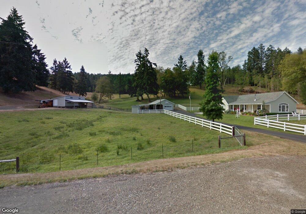
2047 Plat I Rd Sutherlin, OR 97479
Estimated Value: $468,000 - $646,202
4
Beds
3
Baths
1,850
Sq Ft
$301/Sq Ft
Est. Value
About This Home
This home is located at 2047 Plat I Rd, Sutherlin, OR 97479 and is currently estimated at $557,101, approximately $301 per square foot. 2047 Plat I Rd is a home located in Douglas County with nearby schools including East Sutherlin Primary School, West Sutherlin Intermediate School, and Sutherlin Middle School.
Ownership History
Date
Name
Owned For
Owner Type
Purchase Details
Closed on
Dec 9, 2009
Sold by
Schnider Cristina M and Patton Malcolm D
Bought by
Mccracken Steven J and Mccracken Patricia K
Current Estimated Value
Home Financials for this Owner
Home Financials are based on the most recent Mortgage that was taken out on this home.
Original Mortgage
$268,800
Outstanding Balance
$173,722
Interest Rate
4.88%
Mortgage Type
New Conventional
Estimated Equity
$383,379
Purchase Details
Closed on
Jul 9, 2009
Sold by
Alaska Sutherland Knolls Corporation Inc
Bought by
Beckley Resources Llc
Purchase Details
Closed on
Nov 2, 2005
Sold by
Mccracken Steven J and Mccracken Parilee A
Bought by
Schnider Cristina M and Patton Malcolm D
Home Financials for this Owner
Home Financials are based on the most recent Mortgage that was taken out on this home.
Original Mortgage
$244,600
Interest Rate
5.93%
Mortgage Type
Fannie Mae Freddie Mac
Create a Home Valuation Report for This Property
The Home Valuation Report is an in-depth analysis detailing your home's value as well as a comparison with similar homes in the area
Home Values in the Area
Average Home Value in this Area
Purchase History
| Date | Buyer | Sale Price | Title Company |
|---|---|---|---|
| Mccracken Steven J | $336,000 | Ticor Title Company Oregon | |
| Beckley Resources Llc | -- | Amerititle | |
| Schnider Cristina M | $300,890 | Amerititle Inc |
Source: Public Records
Mortgage History
| Date | Status | Borrower | Loan Amount |
|---|---|---|---|
| Open | Mccracken Steven J | $268,800 | |
| Previous Owner | Schnider Cristina M | $244,600 |
Source: Public Records
Tax History Compared to Growth
Tax History
| Year | Tax Paid | Tax Assessment Tax Assessment Total Assessment is a certain percentage of the fair market value that is determined by local assessors to be the total taxable value of land and additions on the property. | Land | Improvement |
|---|---|---|---|---|
| 2025 | $1,466 | $199,546 | -- | -- |
| 2024 | $1,425 | $194,036 | -- | -- |
| 2023 | $1,148 | $156,245 | $0 | $0 |
| 2022 | $74 | $1,256 | $0 | $0 |
| 2021 | $74 | $1,220 | $0 | $0 |
| 2020 | $74 | $143,755 | $0 | $0 |
| 2019 | $73 | $1,159 | $0 | $0 |
| 2018 | $73 | $1,128 | $0 | $0 |
| 2017 | $74 | $1,067 | $0 | $0 |
| 2016 | $74 | $1,067 | $0 | $0 |
| 2015 | $73 | $1,036 | $0 | $0 |
| 2014 | $73 | $1,010 | $0 | $0 |
| 2013 | -- | $984 | $0 | $0 |
Source: Public Records
Map
Nearby Homes
- 339 Justa Ln
- 250 Valley View Rd
- 1555 Northside Rd
- 1175 Northside Rd
- 557 Plat B Rd
- 205 Fair Oaks Rd
- 402 Northside Rd
- 1870 Lakeview Dr
- 1853 Ridge Water Dr
- 161 South Ave
- 1762 E Fourth Ave
- 1300 Fair Oaks Rd
- 660 Jade St
- 1732 E Sixth Ave
- 337 S Grove Ln
- 1316 Sunny Ct
- 337 Arvilla Ct
- 229 N Grove Ln
- 1200 E Central Ave Unit 80
- 1200 E Central Ave Unit 139
- 1995 Plat I Rd
- 2000 Plat I Rd
- 1933 Plat I Rd
- 2203 Plat I Rd
- 1952 Plat I Rd
- 2164 Plat I Rd
- 1914 Plat I Rd
- 2333 Plat I Rd
- 1833 Plat I Rd
- 2246 Plat I Rd
- 1870 Plat I Rd
- 1773 Plat I Rd
- 1818 Plat I Rd
- 2350 Plat I Rd
- 1735 Plat I Rd
- 2343 Plat I Rd
- 1736 Plat I Rd
- 1996 Plat I Rd
- 1953 Plat K Rd
- 205 Fraser Canyon Rd