Estimated Value: $101,000 - $155,000
4
Beds
2
Baths
1,500
Sq Ft
$81/Sq Ft
Est. Value
About This Home
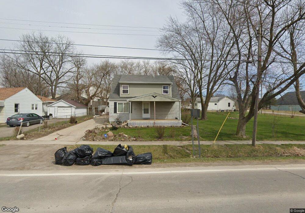
This home is located at 2047 S Graham Rd, Flint, MI 48532 and is currently estimated at $121,133, approximately $80 per square foot. 2047 S Graham Rd is a home located in Genesee County with nearby schools including Carman-Ainsworth High School, Genesee STEM Academy, and St. Paul Lutheran School.
Ownership History
Date
Name
Owned For
Owner Type
Purchase Details
Closed on
May 12, 2023
Sold by
Lucia Victoria Rae
Bought by
Hendricks Chandler
Current Estimated Value
Purchase Details
Closed on
Nov 16, 2021
Sold by
Rae Lucia Victoria
Bought by
Genesee County Community Development Program
Home Financials for this Owner
Home Financials are based on the most recent Mortgage that was taken out on this home.
Original Mortgage
$15,357
Interest Rate
3.09%
Mortgage Type
New Conventional
Create a Home Valuation Report for This Property
The Home Valuation Report is an in-depth analysis detailing your home's value as well as a comparison with similar homes in the area
Home Values in the Area
Average Home Value in this Area
Purchase History
We collect this data history from publicly available records. To have your information removed, we recommend requesting removal directly through your county’s website.
| Date | Buyer | Sale Price | Title Company |
|---|---|---|---|
| Hendricks Chandler | $50,000 | Sterling Title | |
| Genesee County Community Development Program | $5,119 | None Listed On Document |
Source: Public Records
Mortgage History
We collect this data history from publicly available records. To have your information removed, we recommend requesting removal directly through your county’s website.
| Date | Status | Borrower | Loan Amount |
|---|---|---|---|
| Previous Owner | Genesee County Community Development Program | $15,357 |
Source: Public Records
Tax History
| Year | Tax Paid | Tax Assessment Tax Assessment Total Assessment is a certain percentage of the fair market value that is determined by local assessors to be the total taxable value of land and additions on the property. | Land | Improvement |
|---|---|---|---|---|
| 2025 | $1,921 | $52,700 | $0 | $0 |
| 2024 | $1,867 | $46,000 | $0 | $0 |
| 2023 | $504 | $42,900 | $0 | $0 |
| 2022 | $194 | $31,800 | $0 | $0 |
| 2021 | $192 | $0 | $0 | $0 |
| 2020 | $504 | $26,000 | $0 | $0 |
| 2019 | $178 | $0 | $0 | $0 |
| 2018 | $170 | $6,500 | $0 | $0 |
| 2017 | $423 | $6,500 | $0 | $0 |
| 2016 | $175 | $0 | $0 | $0 |
| 2015 | -- | $0 | $0 | $0 |
| 2014 | $537 | $22,500 | $0 | $0 |
| 2012 | -- | $26,700 | $26,700 | $0 |
Source: Public Records
Map
Nearby Homes
- 1374 S Graham Rd
- 2257 Lodge Rd
- 4007 W Court St Unit Suite 3
- 1512 Crescent Lane Dr Lot#46
- 1478 Coachlight Ct
- 2275 Tandy Dr
- 3277 Whitney Ave
- 18.41 Taft Rd
- 4064 Sheraton Dr
- 4010 Reynolds St
- 1260 Gilbert St
- 1008 Tacken St
- 3320 Timberview St
- 10 Acres T A Mansour Blvd
- 3922 Herrick St
- 3288 Tall Oaks Ct
- 3825 Arlene Ave
- 2496 Ketzler Dr
- 870 Tacken St
- 3921 Joyner St
- 3508 Brown St
- 2039 S Graham Rd
- 2044 Lowden Ln
- 2042 Lowden Ln
- 2037 S Graham Rd
- 2036 Lowden Ln
- 4014 Brown St
- 2029 S Graham Rd
- 2030 Lowden Ln
- 2072 S Graham Rd
- 2043 Lowden Ln
- 2026 Lowden Ln
- 2041 Lowden Ln
- 2076 S Graham Rd
- 2021 S Graham Rd
- 2020 Lowden Ln
- 4024 Brown St
- 2031 Lowden Ln
- 4027 Brown St
- 2050 Kenova Dr
Your Personal Tour Guide
Ask me questions while you tour the home.