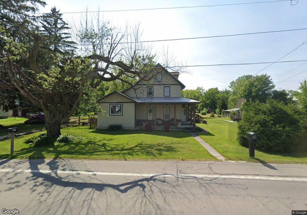
2049 State Route 18 Wakeman, OH 44889
Estimated Value: $216,564 - $330,000
3
Beds
2
Baths
2,028
Sq Ft
$129/Sq Ft
Est. Value
About This Home
This home is located at 2049 State Route 18, Wakeman, OH 44889 and is currently estimated at $261,891, approximately $129 per square foot. 2049 State Route 18 is a home located in Huron County with nearby schools including New London Elementary School, New London Middle School, and New London High School.
Ownership History
Date
Name
Owned For
Owner Type
Purchase Details
Closed on
Mar 11, 2008
Bought by
Marcum Heather D and Marcum Michael A
Current Estimated Value
Purchase Details
Closed on
Jun 14, 2004
Bought by
Grills Heather D
Purchase Details
Closed on
Sep 1, 1999
Sold by
Jordon Kevin L
Bought by
Grills Heather D and Sapienza Jason D
Purchase Details
Closed on
Jul 18, 1979
Bought by
Jordan Kevin L
Create a Home Valuation Report for This Property
The Home Valuation Report is an in-depth analysis detailing your home's value as well as a comparison with similar homes in the area
Home Values in the Area
Average Home Value in this Area
Purchase History
| Date | Buyer | Sale Price | Title Company |
|---|---|---|---|
| Marcum Heather D | -- | -- | |
| Grills Heather D | -- | -- | |
| Grills Heather D | $71,000 | -- | |
| Jordan Kevin L | $31,000 | -- |
Source: Public Records
Tax History Compared to Growth
Tax History
| Year | Tax Paid | Tax Assessment Tax Assessment Total Assessment is a certain percentage of the fair market value that is determined by local assessors to be the total taxable value of land and additions on the property. | Land | Improvement |
|---|---|---|---|---|
| 2024 | $1,876 | $55,700 | $8,500 | $47,200 |
| 2023 | $1,876 | $50,950 | $5,960 | $44,990 |
| 2022 | $1,660 | $50,950 | $5,960 | $44,990 |
| 2021 | $1,661 | $50,950 | $5,960 | $44,990 |
| 2020 | $1,173 | $32,950 | $4,670 | $28,280 |
| 2019 | $1,167 | $32,950 | $4,670 | $28,280 |
| 2018 | $1,082 | $31,180 | $4,670 | $26,510 |
| 2017 | $856 | $25,940 | $4,670 | $21,270 |
| 2016 | $841 | $25,940 | $4,670 | $21,270 |
| 2015 | $841 | $25,940 | $4,670 | $21,270 |
| 2014 | $788 | $23,880 | $4,660 | $19,220 |
| 2013 | $779 | $23,880 | $4,660 | $19,220 |
Source: Public Records
Map
Nearby Homes
- 1491 Vesta Rd
- 1195 Fitchville River Rd
- 4718 Brushwood Rd
- 2904 Zenobia Rd
- 20 Townsend St
- 5429 & 5431 St Rt 303
- 34 Cherdon Cir
- 0 U S 20
- 6175 U S 20
- 0 W Abbott Stony Brook Ln Unit 20253918
- 30 S River St
- 0 Butler Rd N
- 42 Stony Brook Ln
- 20011 Gore Orphanage Rd
- VL W Abbott Stony Brook Ln St
- 31 Depot St
- 22 E Main St
- 27 Deer Run Dr
- 5 Foxwood Cir
- 22 Foxwood Cir
- 2039 State Route 18
- 2038 State Route 18
- 2071 State Route 18
- 2054 Ohio 18
- 2010 Harrison St
- 2030 State Route 18
- 2057 Harrison St
- 2067 Harrison St
- 4968 Zen Rd
- 2020 State Route 18
- 2020 State Route 18
- 2047 Harrison St
- 2037 Harrison St
- 2083 Harrison St
- 1997 State Route 18
- 1997 Ohio 18
- 2027 Harrison St
- 2017 Harrison St
- 2017 Harrison St
- 2017 Harrison St