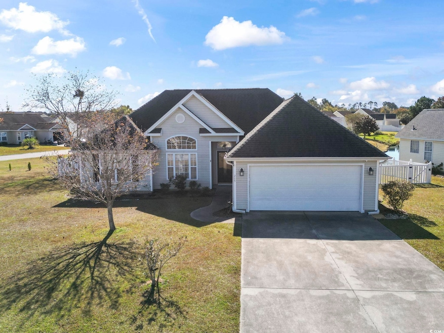
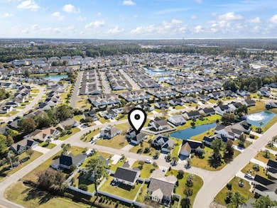
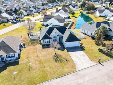
205 Atoll Dr Myrtle Beach, SC 29588
Estimated payment $1,677/month
Highlights
- Very Popular Property
- Lake On Lot
- Lake View
- Lakewood Elementary Rated A
- RV Access or Parking
- Vaulted Ceiling
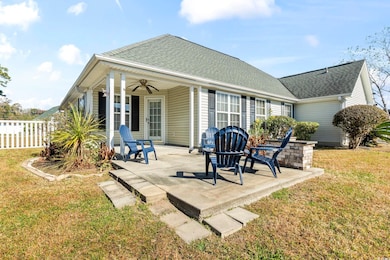
About This Home
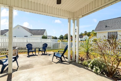
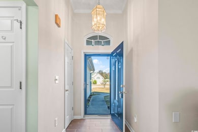
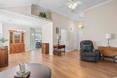
Welcome Home! Perfectly situated in the highly desirable Palmetto Pointe area, this charming SINGLE-STORY, 3-bedroom, 2-bathroom home offers the ideal blend of comfort, convenience, and coastal living—right in the heart of Myrtle Beach. Priced to sell, this is one you won’t want to miss. Step inside to discover a sprawling OPEN FLOOR PLAN designed for effortless everyday living. The spacious living area flows seamlessly into the strategically planned kitchen, complete with ample counter seating and flanked by two inviting dining areas—a layout sure to delight both the everyday cook and the master chef of the family. Unwind in the expansive OWNERS SUITE, featuring a generous WALK-IN CLOSET and a well-appointed en-suite bath with a garden tub, separate walk-in shower, and DUAL VANITIES. Whether you're getting ready for the day ahead or winding down afterward, this space provides the comfort and functionality you need. Two additional bedrooms offer complete flexibility—perfect for guest rooms, a HOME OFFICE, or growing family needs. Whatever your lifestyle requires, this home is ready to adapt. Step outside to your own private retreat: a large COVERED PATIO and an extended open-air patio surrounded by beautiful native plants. Relax around the fire pit, enjoy the serene POND VIEW, and appreciate the fully fenced-in yard that provides privacy, safety, and peace of mind. With its prime location, thoughtful layout, and inviting outdoor spaces, this home truly has it all. Don’t wait—schedule your showing today!
Open House Schedule
-
Saturday, November 22, 20251:00 to 3:00 pm11/22/2025 1:00:00 PM +00:0011/22/2025 3:00:00 PM +00:00New to the Market and Priced to Sell Quick. Don't miss your chance on this home.Add to Calendar
-
Sunday, November 23, 20252:00 to 4:00 pm11/23/2025 2:00:00 PM +00:0011/23/2025 4:00:00 PM +00:00New to the Market. Must See!Add to Calendar
Home Details
Home Type
- Single Family
Est. Annual Taxes
- $519
Year Built
- Built in 2004
Lot Details
- 6,970 Sq Ft Lot
- Fenced
- Rectangular Lot
- Property is zoned PUD
HOA Fees
- $50 Monthly HOA Fees
Parking
- 2 Car Attached Garage
- Garage Door Opener
- RV Access or Parking
Home Design
- Ranch Style House
- Brick Exterior Construction
- Slab Foundation
- Vinyl Siding
- Tile
Interior Spaces
- 1,244 Sq Ft Home
- Vaulted Ceiling
- Ceiling Fan
- Insulated Doors
- Formal Dining Room
- Screened Porch
- Lake Views
Kitchen
- Breakfast Area or Nook
- Breakfast Bar
- Range
- Microwave
- Dishwasher
- Stainless Steel Appliances
- Solid Surface Countertops
- Disposal
Bedrooms and Bathrooms
- 3 Bedrooms
- 2 Full Bathrooms
- Soaking Tub
Laundry
- Laundry Room
- Washer and Dryer Hookup
Home Security
- Storm Doors
- Fire and Smoke Detector
Schools
- Burgess Elementary School
- Saint James Middle School
- Saint James High School
Utilities
- Central Heating and Cooling System
- Underground Utilities
- Water Heater
- Phone Available
- Cable TV Available
Additional Features
- Handicap Accessible
- Lake On Lot
- Outside City Limits
Community Details
- Association fees include trash pickup, common maint/repair, legal and accounting, pest control
- The community has rules related to fencing, allowable golf cart usage in the community
Map
Home Values in the Area
Average Home Value in this Area
Tax History
| Year | Tax Paid | Tax Assessment Tax Assessment Total Assessment is a certain percentage of the fair market value that is determined by local assessors to be the total taxable value of land and additions on the property. | Land | Improvement |
|---|---|---|---|---|
| 2024 | $519 | $10,135 | $3,421 | $6,714 |
| 2023 | $519 | $5,809 | $1,411 | $4,398 |
| 2021 | $450 | $6,543 | $1,411 | $5,132 |
| 2020 | $376 | $6,543 | $1,411 | $5,132 |
| 2019 | $376 | $6,543 | $1,411 | $5,132 |
| 2018 | $318 | $5,051 | $1,411 | $3,640 |
| 2017 | $303 | $5,051 | $1,411 | $3,640 |
| 2016 | $0 | $5,051 | $1,411 | $3,640 |
| 2015 | -- | $5,052 | $1,412 | $3,640 |
| 2014 | $286 | $5,052 | $1,412 | $3,640 |
Property History
| Date | Event | Price | List to Sale | Price per Sq Ft |
|---|---|---|---|---|
| 11/15/2025 11/15/25 | For Sale | $299,900 | -- | $241 / Sq Ft |
Purchase History
| Date | Type | Sale Price | Title Company |
|---|---|---|---|
| Deed | $130,290 | -- | |
| Warranty Deed | $95,600 | -- |
Mortgage History
| Date | Status | Loan Amount | Loan Type |
|---|---|---|---|
| Open | $100,000 | Purchase Money Mortgage |
Source: Coastal Carolinas Association of REALTORS®
MLS Number: 2527504
APN: 44116020052
Disclaimer: Certain information contained herein is derived from information provided by parties other than Homes.com. All information provided is deemed reliable, but is not guaranteed to be accurate and should be independently verified.
![]() Provided courtesy of the Coastal Carolinas MLS. Copyright 2025 of the Coastal Carolinas MLS. All rights reserved. Information is provided exclusively for consumers' personal, non-commercial use, and may not be used for any purpose other than to identify prospective properties consumers may be interested in purchasing, and that the data is deemed reliable but is not guaranteed accurate by the Coastal Carolinas MLS.
Provided courtesy of the Coastal Carolinas MLS. Copyright 2025 of the Coastal Carolinas MLS. All rights reserved. Information is provided exclusively for consumers' personal, non-commercial use, and may not be used for any purpose other than to identify prospective properties consumers may be interested in purchasing, and that the data is deemed reliable but is not guaranteed accurate by the Coastal Carolinas MLS.
- 987 Wrigley Dr Unit 233
- 313 Harbour Reef Dr
- 578 Banks Dr Unit 82
- 113 Butkus Dr Unit 3
- 109 Butkus Dr Unit 3
- 117 Butkus Dr Unit 2
- 117 Butkus Dr Unit 6
- 292 Palm Cove Cir
- 608 Sea Sparrow St Unit 608
- 6048 Zoe Way Unit Lexington; Lot 717
- 118 Butkus Dr Unit 2
- 3979 Forsythia Ct Unit 203
- 3979 Forsythia Ct Unit Azalea Lakes 201
- 3973 Forsythia Ct Unit 103
- 109 Old Town Way Unit 4
- 3965 Forsythia Ct Unit 202
- 140 Olde Towne Way Unit 1
- 232 Palm Cove Cir Unit Palm Cove
- 113 Olde Towne Way Unit 3
- 1036 Great Lakes Cir
- 113 Butkus Dr Unit 3
- 3919 Carnegie Ave
- 3815 Maypop Cir
- 3973 Forsythia Ct Unit ID1329038P
- 161 Olde Towne Way
- 190 Olde Towne Way Unit 3
- 3947 Gladiola Ct Unit 301
- 405 Harbour Reef Dr
- 3973 Woolcock Dr Unit 4208.1408792
- 3973 Woolcock Dr Unit 2308.1408790
- 3973 Woolcock Dr Unit 3308.1408794
- 3973 Woolcock Dr
- 3927 Gladiola Ct Unit 204
- 3851 Cape Landing Dr
- 203 Plantation Dr Unit ID1330792P
- 305 Brookfield Dr
- 850 Hayes Point Cir
- 4641 Socastee Blvd Unit B-5
- 1758 Edgewood Dr
- 4641 Socastee Blvd Unit E1
