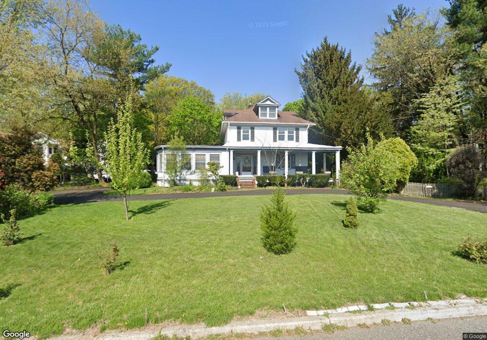
205 Bridgeboro Rd Moorestown, NJ 08057
Estimated Value: $749,606 - $1,058,000
4
Beds
3
Baths
2,680
Sq Ft
$346/Sq Ft
Est. Value
About This Home
This home is located at 205 Bridgeboro Rd, Moorestown, NJ 08057 and is currently estimated at $926,402, approximately $345 per square foot. 205 Bridgeboro Rd is a home located in Burlington County with nearby schools including George C. Baker Elementary School, Moorestown Upper Elementary School, and William Allen Middle School.
Ownership History
Date
Name
Owned For
Owner Type
Purchase Details
Closed on
Dec 21, 2001
Current Estimated Value
Purchase Details
Closed on
Jul 27, 2001
Sold by
Rudy Joel S and Rudy Lois D
Bought by
Rudy Lois D
Create a Home Valuation Report for This Property
The Home Valuation Report is an in-depth analysis detailing your home's value as well as a comparison with similar homes in the area
Home Values in the Area
Average Home Value in this Area
Purchase History
| Date | Buyer | Sale Price | Title Company |
|---|---|---|---|
| -- | -- | -- | |
| Rudy Lois D | -- | -- |
Source: Public Records
Tax History Compared to Growth
Tax History
| Year | Tax Paid | Tax Assessment Tax Assessment Total Assessment is a certain percentage of the fair market value that is determined by local assessors to be the total taxable value of land and additions on the property. | Land | Improvement |
|---|---|---|---|---|
| 2025 | $12,210 | $430,400 | $199,600 | $230,800 |
| 2024 | $11,840 | $430,400 | $199,600 | $230,800 |
| 2023 | $11,840 | $430,400 | $199,600 | $230,800 |
| 2022 | $11,720 | $430,400 | $199,600 | $230,800 |
| 2021 | $10,693 | $430,400 | $199,600 | $230,800 |
| 2020 | $11,492 | $430,400 | $199,600 | $230,800 |
| 2019 | $11,289 | $430,400 | $199,600 | $230,800 |
| 2018 | $10,984 | $430,400 | $199,600 | $230,800 |
| 2017 | $11,079 | $430,400 | $199,600 | $230,800 |
| 2016 | $11,040 | $430,400 | $199,600 | $230,800 |
| 2015 | $10,906 | $430,400 | $199,600 | $230,800 |
| 2014 | $10,355 | $430,400 | $199,600 | $230,800 |
Source: Public Records
Map
Nearby Homes
- 863 Golf View Rd
- 744 Signal Light Rd
- 205 E Central Ave
- 343 Tom Brown Rd
- 7 Whitetail Ct
- 347 Tom Brown Rd
- 628 Windsock Way
- 308 Elm St
- 133 Plum St Unit 6
- 80 E 3rd St
- 82 E 3rd St
- 66 E 3rd St
- 50 E 3rd St
- 415 Bridgeboro Rd
- 543 Bethel Ave
- 15 E 2nd St
- 142 Fox Chase Dr
- 493 N Church St
- 2801 Riverton Rd
- 25 Oriole Way
- 207 Bridgeboro Rd
- 5 Rhoads Ave
- 201 Bridgeboro Rd
- 3 Rhoads Ave
- 211 Bridgeboro Rd
- 1 Rhoads Ave
- 213 Bridgeboro Rd
- 879 Golf View Rd
- 202 Bridgeboro Rd
- 877 Golf View Rd
- 7 Broadacres Ct
- 120 Pheasant Field Ln
- 875 Golf View Rd
- 302 Bridgeboro Rd
- 116 Pheasant Field Ln
- 880 Golf View Rd
- 124 Pheasant Field Ln
- 112 Pheasant Field Ln
- 6 Broadacres Ct
- 1 Broadacres Ct